Background: Bangladesh came into existence in 1971 when Bengali East Pakistan seceded from its union with West Pakistan. About a third of this extremely poor country annually floods during the monsoon rainy season, hampering economic development.
Government type: republic
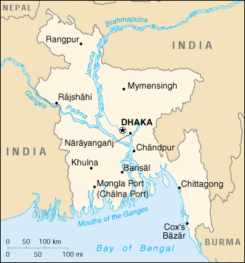
Capital: Dhaka
Currency: 1 taka (Tk) = 100 poisha
Geography of Bangladesh
Location: Southern Asia, bordering the Bay of Bengal, between Burma and India
Geographic coordinates: 24 00 N, 90 00 E
Map references: Asia
Area:
total: 144,000 sq. km
land: 133,910 sq. km
water: 10,090 sq. km
Land boundaries:
total: 4,246 km
border countries: Burma 193 km, India 4,053 km
Coastline: 580 km
Maritime claims:
contiguous zone: 18 nm
continental shelf: up to the outer limits of the continental margin
exclusive economic zone: 200 nm
territorial sea: 12 nm
Climate: tropical; cool, dry winter (October to March); hot, humid summer (March to June); cool, rainy monsoon (June to October)
Terrain: mostly flat alluvial plain; hilly in southeast
Elevation extremes:
lowest point: Indian Ocean 0 m
highest point: Keokradong 1,230 m
Natural resources: natural gas, arable land, timber
Land use:
arable land: 73%
permanent crops: 2%
permanent pastures: 5%
forests and woodland: 15%
other: 5% (1993 est.)
Irrigated land: 31,000 sq. km (1993 est.)
Natural hazards: droughts, cyclones; much of the country routinely flooded during the summer monsoon season
Environment – current issues: many people are landless and forced to live on and cultivate flood-prone land; water-borne diseases prevalent in surface water; water pollution, especially of fishing areas, results from the use of commercial pesticides; ground water contaminated by naturally-occurring arsenic; intermittent water shortages because of falling water tables in the northern and central parts of the country; soil degradation and erosion; deforestation; severe overpopulation.
Environment – international agreements:
party to: Biodiversity, Climate Change, Desertification, Endangered Species, Environmental Modification, Hazardous Wastes, Nuclear Test Ban, Ozone Layer Protection, Wetlands
signed, but not ratified: Law of the Sea
The Land
The physiography of Bangladesh is characterized by two distinctive features: a broad deltaic plain subject to frequent flooding, and a small hilly region crossed by swiftly flowing rivers. The country has an area of 144,000 square kilometers and extends 820 kilometers north to south and 600 kilometers east to west. Bangladesh is bordered on the west, north, and east by a 2,400-kilometer land frontier with India and, in the southeast, by a short land and water frontier (193 kilometers) with Burma. On the south is a highly irregular deltaic coastline of about 600 kilometers, fissured by many rivers and streams flowing into the Bay of Bengal. The territorial waters of Bangladesh extend 12 nautical miles, and the exclusive economic zone of the country is 200 nautical miles.
Roughly 80 percent of the landmass is made up of fertile alluvial lowland called the Bangladesh Plain. The plain is part of the larger Plain of Bengal, which is sometimes called the Lower Gangetic Plain. Although altitudes up to 105 meters above sea level occur in the northern part of the plain, most elevations are less than 10 meters above sea level; elevations decrease in the coastal south, where the terrain is generally at sea level. With such low elevations and numerous rivers, water–and concomitant flooding–is a predominant physical feature. About 10,000 square kilometers of the total area of Bangladesh is covered with water, and larger areas are routinely flooded during the monsoon season.
The only exceptions to Bangladesh’s low elevations are the Chittagong Hills in the southeast, the Low Hills of Sylhet in the northeast, and highlands in the north and northwest. The Chittagong Hills constitute the only significant hill system in the country and, in effect, are the western fringe of the northsouth mountain ranges of Burma and eastern India. The Chittagong Hills rise steeply to narrow ridge lines, generally no wider than 36 meters, 600 to 900 meters above sea level. At 1,046 meters, the highest elevation in Bangladesh is found at Keokradong, in the southeastern part of the hills. Fertile valleys lie between the hill lines, which generally run north-south. West of the Chittagong Hills is a broad plain, cut by rivers draining into the Bay of Bengal, that rises to a final chain of low coastal hills, mostly below 200 meters, that attain a maximum elevation of 350 meters. West of these hills is a narrow, wet coastal plain located between the cities of Chittagong in the north and Cox’s Bazar in the south.
About 67 percent of Bangladesh’s nonurban land is arable. Permanent crops cover only 2 percent, meadows and pastures cover 4 percent, and forests and woodland cover about 16 percent. The country produces large quantities of quality timber, bamboo, and sugarcane. Bamboo grows in almost all areas, but high-quality timber grows mostly in the highland valleys. Rubber planting in the hilly regions of the country was undertaken in the 1980s, and rubber extraction had started by the end of the decade. A variety of wild animals are found in the forest areas, such as in the Sundarbans on the southwest coast, which is the home of the worldfamous Royal Bengal Tiger. The alluvial soils in the Bangladesh Plain are generally fertile and are enriched with heavy silt deposits carried downstream during the rainy season.
Climate
Bangladesh has a subtropical monsoon climate characterized by wide seasonal variations in rainfall, moderately warm temperatures, and high humidity. Regional climatic differences in this flat country are minor. Three seasons are generally recognized: a hot, humid summer from March to June; a cool, rainy monsoon season from June to October; and a cool, dry winter from October to March. In general, maximum summer temperatures range between 32°C and 38°C. April is the warmest month in most parts of the country. January is the coldest month, when the average temperature for most of the country is 10°C.
Winds are mostly from the north and northwest in the winter, blowing gently at one to three kilometers per hour in northern and central areas and three to six kilometers per hour near the coast. From March to May, violent thunderstorms, called northwesters by local English speakers, produce winds of up to sixty kilometers per hour. During the intense storms of the early summer and late monsoon season, southerly winds of more than 160 kilometers per hour cause waves to crest as high as 6 meters in the Bay of Bengal, which brings disastrous flooding to coastal areas.
Heavy rainfall is characteristic of Bangladesh. With the exception of the relatively dry western region of Rajshahi, where the annual rainfall is about 160 centimeters, most parts of the country receive at least 200 centimeters of rainfall per year. Because of its location just south of the foothills of the Himalayas, where monsoon winds turn west and northwest, the region of Sylhet in northeastern Bangladesh receives the greatest average precipitation. From 1977 to 1986, annual rainfall in that region ranged between 328 and 478 centimeters per year. Average daily humidity ranged from March lows of between 45 and 71 percent to July highs of between 84 and 92 percent, based on readings taken at selected stations nationwide in 1986.
About 80 percent of Bangladesh’s rain falls during the monsoon season. The monsoons result from the contrasts between low and high air pressure areas that result from differential heating of land and water. During the hot months of April and May hot air rises over the Indian subcontinent, creating low-pressure areas into which rush cooler, moisture-bearing winds from the Indian Ocean. This is the southwest monsoon, commencing in June and usually lasting through September. Dividing against the Indian landmass, the monsoon flows in two branches, one of which strikes western India. The other travels up the Bay of Bengal and over eastern India and Bangladesh, crossing the plain to the north and northeast before being turned to the west and northwest by the foothills of the Himalayas.
Natural calamities, such as floods, tropical cyclones, tornadoes, and tidal bores–destructive waves or floods caused by flood tides rushing up estuaries–ravage the country, particularly the coastal belt, almost every year. Between 1947 and 1988, thirteen severe cyclones hit Bangladesh, causing enormous loss of life and property. In May 1985, for example, a severe cyclonic storm packing 154 kilometer-per-hour winds and waves 4 meters high swept into southeastern and southern Bangladesh, killing more than 11,000 persons, damaging more than 94,000 houses, killing some 135,000 head of livestock, and damaging nearly 400 kilometers of critically needed embankments. Annual monsoon flooding results in the loss of human life, damage to property and communication systems, and a shortage of drinking water, which leads to the spread of disease. For example, in 1988 two-thirds of Bangladesh’s sixty-four districts experienced extensive flood damage in the wake of unusually heavy rains that flooded the river systems. Millions were left homeless and without potable water. Half of Dhaka, including the runways at the Zia International Airport–an important transit point for disaster relief supplies–was flooded. About 2 million tons of crops were reported destroyed, and relief work was rendered even more challenging than usual because the flood made transportation of any kind exceedingly difficult.
There are no precautions against cyclones and tidal bores except giving advance warning and providing safe public buildings where people may take shelter. Adequate infrastructure and air transport facilities that would ease the sufferings of the affected people had not been established by the late 1980s. Efforts by the government under the Third Five-Year Plan (1985-90) were directed toward accurate and timely forecast capability through agrometeorology, marine meteorology, oceanography, hydrometeorology, and seismology. Necessary expert services, equipment, and training facilities were expected to be developed under the United Nations Development Programme.
River Systems
The rivers of Bangladesh mark both the physiography of the nation and the life of the people. About 700 in number, these rivers generally flow south. The larger rivers serve as the main source of water for cultivation and as the principal arteries of commercial transportation. Rivers also provide fish, an important source of protein. Flooding of the rivers during the monsoon season causes enormous hardship and hinders development, but fresh deposits of rich silt replenish the fertile but overworked soil. The rivers also drain excess monsoon rainfall into the Bay of Bengal. Thus, the great river system is at the same time the country’s principal resource and its greatest hazard.
The profusion of rivers can be divided into five major networks. The Jamuna-Brahmaputra is 292 kilometers long and extends from northern Bangladesh to its confluence with the Padma. Originating as the Yarlung Zangbo Jiang in China’s Xizang Autonomous Region (Tibet) and flowing through India’s state of Arunachal Pradesh, where it becomes known as the Brahmaputra (“Son of Brahma”), it receives waters from five major tributaries that total some 740 kilometers in length. At the point where the Brahmaputra meets the Tista River in Bangladesh, it becomes known as the Jamuna. The Jamuna is notorious for its shifting subchannels and for the formation of fertile silt islands (chars). No permanent settlements can exist along its banks.
The second system is the Padma-Ganges, which is divided into two sections: a 258-kilometer segment, the Ganges, which extends from the western border with India to its confluence with the Jamuna some 72 kilometers west of Dhaka, and a 126-kilometer segment, the Padma, which runs from the Ganges-Jamuna confluence to where it joins the Meghna River at Chandpur. The Padma-Ganges is the central part of a deltaic river system with hundreds of rivers and streams–some 2,100 kilometers in length–flowing generally east or west into the Padma.
The third network is the Surma-Meghna system, which courses from the northeastern border with India to Chandpur, where it joins the Padma. The Surma-Meghna, at 669 kilometers by itself the longest river in Bangladesh, is formed by the union of six lesser rivers. Below the city of Kalipur it is known as the Meghna. When the Padma and Meghna join together, they form the fourth river system–the Padma-Meghna–which flows 145 kilometers to the Bay of Bengal.
This mighty network of four river systems flowing through the Bangladesh Plain drains an area of some 1.5 million square kilometers. The numerous channels of the Padma-Meghna, its distributaries, and smaller parallel rivers that flow into the Bay of Bengal are referred to as the Mouths of the Ganges. Like the Jamuna, the Padma-Meghna and other estuaries on the Bay of Bengal are also known for their many chars.
A fifth river system, unconnected to the other four, is the Karnaphuli. Flowing through the region of Chittagong and the Chittagong Hills, it cuts across the hills and runs rapidly downhill to the west and southwest and then to the sea. The Feni, Karnaphuli, Sangu, and Matamuhari–an aggregate of some 420 kilometers–are the main rivers in the region. The port of Chittagong is situated on the banks of the Karnaphuli. The Karnaphuli Reservoir and Karnaphuli Dam are located in this area. The dam impounds the Karnaphuli River’s waters in the reservoir for the generation of hydroelectric power.
During the annual monsoon period, the rivers of Bangladesh flow at about 140,000 cubic meters per second, but during the dry period they diminish to 7,000 cubic meters per second. Because water is so vital to agriculture, more than 60 percent of the net arable land, some 9.1 million hectares, is cultivated in the rainy season despite the possibility of severe flooding, and nearly 40 percent of the land is cultivated during the dry winter months. Water resources development has responded to this “dual water regime” by providing flood protection, drainage to prevent overflooding and waterlogging, and irrigation facilities for the expansion of winter cultivation. Major water control projects have been developed by the national government to provide irrigation, flood control, drainage facilities, aids to river navigation and road construction, and hydroelectric power. In addition, thousands of tube wells and electric pumps are used for local irrigation. Despite severe resource constraints, the government of Bangladesh has made it a policy to try to bring additional areas under irrigation without salinity intrusion.
Water resources management, including gravity flow irrigation, flood control, and drainage, were largely the responsibility of the Bangladesh Water Development Board. Other public sector institutions, such as the Bangladesh Krishi Bank, the Bangladesh Rural Development Board, the Bangladesh Bank, and the Bangladesh Agricultural Development Corporation were also responsible for promotion and development of minor irrigation works in the private sector through government credit mechanisms.
People of Bangladesh
Population: 144,319,628 (July 2005 est.)
Age structure:
0-14 years: 35.04% (male 23,550,607; female 22,451,006)
15-64 years: 61.6% (male 41,432,123; female 39,434,633)
65 years and over: 3.36% (male 2,389,639; female 2,011,852)
Population growth rate: 1.59%
Birth rate: 25.3 births/1,000 population
Death rate: 8.6 deaths/1,000 population
Net migration rate: -0.76 migrant(s)/1,000 population
Infant mortality rate: 69.85 deaths/1,000 live births
Life expectancy at birth:
total population: 60.54 years
male: 60.74 years
female: 60.33 years
Total fertility rate: 2.78 children born/woman
Nationality:
noun: Bangladeshi(s)
adjective: Bangladesh
Ethnic groups: Bengali 98%, tribal groups, non-Bengali Muslims (1998)
Religions: Muslim 83%, Hindu 16%, other 1% (1998)
Languages: Bangla (official, also known as Bengali), English
Literacy:
definition: age 15 and over can read and write
total population: 56%
male: 63%
female: 49% (2000 est.)
History of Bangladesh
THE WORLD FREQUENTLY RECEIVES bad news from Bangladesh. So adverse is the economic situation in Bangladesh that some have referred to it not as a Third World developing nation but as member of the “fourth world,” the poorest of the poor. Its population of 110 million–the eighth largest in the world–lives on constricted land affected by an unkind climate. There is relatively little industry, and most people live at the subsistence level in rural areas. The political system is unstable, characterized by military coups, authoritarian regimes, civil violence, and a poor human rights record. Adding to the nation’s woes are natural disasters. Tropical storms whipping in from the Bay of Bengal have repeatedly devastated the country, causing huge losses of life. In 1988 record floods caused by monsoon rains inundated two-thirds of the country, setting back economic growth. International lending and aid institutions bolster the country, but the problems are so massive that no one predicts near-term major improvements.
Despite its problems, Bangladesh is a land of miracles and heroic accomplishments. Using traditional methods, farmers manage to produce enough food to maintain one of the densest concentrations of rural people in the world. The Bangladeshi people have liberated themselves twice, from the United Kingdom and from Pakistan. Perhaps the greatest deeds are cultural. The Bangla language has a distinguished history in literature and remains one of the most dynamic forces in South Asian arts and humanities. In Bangladesh, local language and artistic forms are combined with the Islamic religion in a special blend of orthodoxy and cultural nationalism. United by strong village traditions, the struggle for existence, the legacy of the freedom movement, the Bangla language, and Islam, most Bangladeshis retain considerable optimism and pride in their nation.
The economic and political situation in Bangladesh has its roots in the complex relationship between its unusual geography and its history during the last 200 years. Most of the country is a low-lying delta where four major river systems come together. The land is subject to heavy annual monsoon flooding followed by a long dry season. The extreme conditions support a fertile environment for agriculture but often demand a high cost from cultivators, who are confronted with the conflicting demands of irrigation systems and flood prevention measures. For these reasons, the area that is Bangladesh remained a frontier until the last few centuries, and the wild characteristics of the frontier still dominate society on newly formed islands that continually emerge along the courses of silty rivers and along the coast.
High mountain walls to the north and the east block easy access to East Asia and Southeast Asia, orienting the country toward Indian civilization, but from the Indian standpoint Bangladesh stands on the periphery of culture and politics. While the hallmarks of civilization first appeared in northwest India and Pakistan at least 4,000 years ago, and a vibrant urban society existed in north India by 500 B.C., large-scale social organization in the area that became Bangladesh developed only by the seventh century A.D. The peripheral position of Bangladesh allowed the long-term survival there of cultural motifs that had been absorbed into history in most other parts of the subcontinent. Buddhism, for example, survived in Bangladesh as a royal cult and a popular religion long after it had died out in most of India. Even during the Mughal Empire (1526-1858), the neglected eastern wing of the province of Bengal became part of a pan-Indian political system but remained a scene of political disunity and piracy. Under these conditions the population remained relatively small until the nineteenth century, and there was little indication of the intense pressure on resources that would develop by the twentieth century. European traders arrived in the region in the sixteenth and seventeenth centuries by following traditional Indian Ocean trade routes. They found a prosperous Bengal dotted with small commercial centers where a dynamic handloom weaving industry produced world-class textiles. As the power of the Mughal Empire waned in the early eighteenth century, the British East India Company became the dominant force in Bengal, but with fateful consequences. The British chose Calcutta in West Bengal as the center of their operations, resulting in a decisive westward shift of commercial interests and capital. The conquest of Bengal coincided with Europe’s Industrial Revolution, driven in its early stages by the mechanization of the British textile industry. British policy deliberately discouraged the export of finished textiles to Britain and instead encouraged the spread of British-made goods in the colonies. The handloom industry was ruined, resulting in the collapse of the old commercial networks in Bengal. Meanwhile, British and Indian entrepreneurs looking for investment opportunities in the East Bengal countryside found that rice would support the growing population in Calcutta and that jute would satisfy the world market for sacking material.
As a result of these forces, during the nineteenth century East Bengal became a purely agricultural society, dominated by rice and jute, with few opportunities in commerce or manufacturing. The British administration provided some basic public works for irrigation and transportation, encouraged land reclamation, prevented large-scale warfare, and implemented rudimentary public health measure. The policies of the British encouraged population growth but at the same time discouraged the urban and industrial development that had absorbed population increases in Europe. By the twentieth century, rapid population increases were outstripping advances in agriculture, and millions of Bengalis were trapped in subsistence agriculture with no alternative form of livelihood.
As nationalism began to grow in South Asia during the late nineteenth century, it accompanied a worldwide Islamic revival that found a rich field for expression in East Bengal. British education and economic opportunities under the colonial government tended to benefit Hindus, who dominated the jute and rice trade and formed a landlord class, while the mass of poor cultivators were mostly Muslims. The British encouraged communal religious consciousness by implementing limited election systems with separate electorates for Hindus and Muslims, a strategy that preserved the rights of minority communities but also allowed the colonial administration to play one side against the other throughout the early twentieth century. The profound doctrinal differences between Hinduism and Islam, the disproportionate opportunities for Hindus and Muslims in the colonial economy, and the growing political competition created a widening rift between the two religious communities. Muslim leaders in Bengal, aware of the deepening economic crisis there, argued at an early date for the separation of the eastern and western parts of Bengal, allowing the Muslim majority in the east greater expression in determining their destiny. The British government responded by dividing Bengal in 1905 but after only seven years rescinded the order, due to pressure throughout India from nationalist forces dominated, in the eyes of Bengali Muslims, by Hindu interests. By the 1940s, when British and Japanese armies were fighting nearby and famine had killed hundreds of thousands of people, the masses of Muslim Bengalis backed the All-India Muslim League (Muslim League), established in 1906, with its call for a separate Islamic state. Amid widespread communal violence, during which many East Bengal Hindus migrated to Hindu areas of India, East Bengal became part of the new nation of Pakistan in 1947 as the East Wing, or East Pakistan.
The issue of language, which quickly divided East Pakistan and West Pakistan, was a symbol for the unique role of Islam in the culture of East Pakistan. Conversion to Islam in Bengal had been a movement of the masses since the twelfth century, a rebellion against caste ideology that had kept peasants subservient to landlords. Embracing Islam did not mean the adoption of a new, elite language and culture, however. Instead, the ancient Bangla language, which was based on Sanskrit, remained a vital force and had relatively few imports of Arabic or Persian terminology. The Bangla renaissance, a literary movement in reaction to British education in the late nineteenth century, found its roots in the long and rich history of Bengali folk literature and produced Nobel Prize winner Rabindranath Tagore. The love of Bangla that permeated all levels of society had links with a large and well-known religious literature created by mystic poets who spread the love of God regardless of communal differences. The doctrinal positions of Bengali Islam were orthodox, but a wide variety of popular religious practices linked originally to polytheism remained important in the countryside.
This web of Bangla language and culture was alien to the leaders of West Pakistan. Outside of Bengal, the preferred language of South Asian Muslims was Urdu, a combination of Sanskritic languages and Persian with a large admixture of Arabic terms. The reforming ideology of many Muslim nationalists in north and northwest India aimed at a return to the original message of Muhammad and a revival of Islam’s Arabic roots. Mohammad Ali Jinnah, the founder of Pakistan, expressed the viewpoint of the majority in the Muslim League when he argued for one language–Urdu–that would unify the two wings of the nation. In 1952 the attempts to impose Urdu as the second language in East Pakistan provoked severe riots, leading to the death of two students–an event still remembered in Bangladesh as Martyrs’ Day, an annual holiday celebrating the survival of Bangla. Until 1971 the language issue continued to boil, as Bengali nationalists refused to compromise their long-standing cultural traditions.
Neither East Pakistan nor West Pakistan had experienced democratic government until their separation from India in 1947, but the British-educated leaders of the Muslim League were determined to implement parliamentary rule. The task proved nearly impossible. The country was under constant pressure from India, the government and economy had to be constructed anew, ethnic divisions rocked West Pakistan, and neglect of East Pakistan by the central government pushed the nation toward civil war. Amid a political crisis, the minister of defense, General Mohammad Ayub Khan, accumulated increasing powers under the constitution and finally implemented military rule over Pakistan in 1958. He later engineered elections that made him president and allowed a return to parliamentary government dominated by his own party and military interests. The pattern of crisis, military takeover, and return to democracy directed by the generals was to recur in Pakistan and Bangladesh.
After the bloody war of independence in 1971, the leaders of Bangladesh implemented a republican form of government, directed by Sheikh Mujibur Rahman (Mujib). As the new administration tried to cope with huge economic problems, it did not take long for the traditional factionalism of Bengali politics to resurface in the new nation. Mujib’s party was committed to socialist reconstruction, but communist and socialist groups advocated further revolutionary change while conservative religious and military interests opposed socialism. Mujib began to implement an authoritarian, single-party dictatorship in 1974, but military factions revolted the following year, killed him along with most of his family, and plunged the nation into a period of chaos. Army chief of staff General Ziaur Rahman (Zia) accumulated more and more power and finally implemented martial law in 1976. He organized his own political party, manipulated elections that packed Parliament with his supporters, and became president in national elections in 1978. The rise to power of military interests followed closely the pattern set earlier by Ayub and the army in Pakistan.
The parallels with Pakistan continued during the 1980s. After the loss of Bangladesh, Pakistani politics had drifted under civilian regimes until 1977, when General Zia ul Haq took control and directed the nation until his sudden death in an air crash in August 1988. His regime slowly returned to a parliamentary government directed by his own party. In Bangladesh, President Zia’s assassination in 1981 deprived the country of its most effective leader since independence. After a brief interlude under a weak civilian government, army chief of staff Lieutenant General Hussain Muhammad Ershad took power in a bloodless coup. Ershad’s policies during the 1980s centered on creating his own political party, packing Parliament with his supporters, and winning election as president in 1986. By 1988 Bangladesh was officially a republic with a popularly elected government, but Ershad’s Jatiyo Party (National Party) dominated all levels of administration and representative government. The parliamentary system allowed political opposition, however, and a wide range of political parties remained active, headed by the political successors of Mujib and Zia. The political opposition refused to give legitimacy to Ershad and his military supporters and generally declined to participate in parliamentary elections. Instead, the opposition organized periodic demonstrations and strikes that disrupted the country. The opposition was plagued with political factionalism that permeated Bangladeshi politics down to the village level, and frequent states of emergency kept coalitions from forming an effective unified front. Meanwhile, administrative reforms under Ershad’s regime allowed the voters to elect popular representatives to local governing bodies with a wide range of authority, giving local elites and the electorate a real stake in Ershad’s political system. In the late 1980s, it appeared that military democracy was entrenched for the long term in Bangladesh.
The grim economic situation remained the most important problem for the young nation. Decades of skewed development under the British, followed by neglect under Pakistan and the destruction caused by the 1971 war, left the country prostrate during the early 1970s. The Mujib and Zia years witnessed major accomplishments in repairing damage and setting up the basic administrative machinery needed to run the country. At no time after independence, however, did Bangladesh experience sustained rates of economic growth sufficient to allow the country to outrun population growth and enter a period of rapid development. With few mineral resources, almost no industrial infrastructure, and a mostly unskilled labor force, Bangladesh depended on imports for most of the basic requirements of a modern nation. Its exports, on the other hand, were agricultural commodities, especially jute, that declined in real value and were subject to uncontrolled fluctuations in world demand. Under these circumstances, the economy depended on large annual inputs of foreign aid. In fact, since independence more than 85 percent of the annual development budget of Bangladesh relied on foreign aid receipts. Without this aid, the country would certainly have experienced disaster; with the aid, the economy achieved stability and even registered moderate advances that allowed it to survive.
In its unenviable status as “largest poorest” country in the world, Bangladesh was a test case for development strategies. The Mujib government nationalized the jute industry and other major industries, and the officially expressed purpose of the country was to build a socialist economy. In the first years after independence, there were serious thoughts of nationalizing all economic endeavors and collectivizing agriculture, a major departure from the traditional system of private ownership. Under the more conservative governments of Zia and Ershad, however, Bangladesh increasingly withdrew from the socialist path, and the administration slowly denationalized commercial and industrial enterprises. As the centrally planned economy declined, decentralized development strategies and private initiative became more important and were supported by large international donors, such as the World Bank and the International Monetary Fund.
In rural areas, the government administered aid to major irrigation and flood control projects, while allotting an increasing percentage of resources to local government bodies at the subdistrict (upazila) level staffed by civil servants but directed by elected local representatives. This process funneled capital and decision-making power into the hands of relatively wealthy or influential local elites, who then created employment opportunities for land- poor or landless laborers. In urban areas, development concentrated on major infrastructure projects such as power plants, as well as the encouragement of private enterprise for the export sector. By encouraging private industry, the government and international donors aimed to create jobs that would eventually provide an alternate source of income to unskilled or semiskilled laborers. The 1980s witnessed some major industrial advances, including a remarkable expansion of the ready-made garment industry and an export-oriented processed seafood industry. But was it enough? The underlying assumption of these development strategies was that urban capitalists and rural elites could create enough new jobs to outrun population increases in the future. The unanswered questions were whether the masses of poor workers would benefit quickly enough or whether they would rebel as they witnessed the growth of an influential Bangladeshi middle class. Massive popular unrest, encouraged by the political opposition, was an ever-present alternative to the government’s development strategies.
The necessity for development aid underlay the foreign policy of Bangladesh, which remained decidedly nonaligned in world politics. During the first few years of independence, a close relationship with India reflected the early political isolation of Bangladesh and its dependence on its big neighbor for military protection as well as economic support. After achieving recognition by most countries, including Pakistan, by 1975 Bangladesh was ready to diversify its international connections when Mujib’s death severed the special relationship with India and a concomitant one with the Soviet Union. The subsequent Zia and Ershad governments moved closer to the sources of aid: Japan, the United States, Canada, Western Europe, China, the wealthy Arab nations, and the big international lending agencies. At no time, however, did Bangladesh subordinate its foreign policy to its dependence on foreign donors. As a member of major international forums, such as the United Nations, the Nonaligned Movement, and the Commonwealth of Nations, Bangladesh advocated a new international economic order and an end to superpower interference in the affairs of sovereign states. Bangladesh’s status as a populous but poor country without foreign alliances allowed it to take outspoken stands and to play a leading role among the nations of the Third World.
High international visibility and clear neutrality were important security strategies for Bangladesh because the nation’s military capacity was insufficient to effectively defend the country against foreign adversaries. The most likely foe was India, which surrounds Bangladesh on three sides and could quickly overrun the country. Disputes with India began during the trauma of separation in 1947, were glossed over during the honeymoon period of the early 1970s, and began again in earnest during the late 1970s. Despite the intense nationalist feelings on both sides of the border, it seemed unlikely that India (or any other nation) would launch an attack, risking world censure and bringing in its wake the inherited problems of Bangladesh.
Bangladesh maintained, with help from China and other nations, an army of 90,000 personnel, a small air force and navy, and several paramilitary border and security forces. The roles of these forces in national defense were in reality subordinate to their roles in internal security. Military leaders repeatedly used the military to launch coups or to maintain order during massive campaigns of civil disobedience by the opposition parties. The army was also involved in ongoing counterinsurgency operations against tribal groups in the Chittagong Hills, where guerrillas of tribal minorities were fighting for independence. The ever-present threat of army intervention guaranteed the continuation of either military regimes or democratic governments that clearly represented the interests of the armed forces.
In the late 1980s, there was still hope for Bangladesh. The gigantic economic disasters predicted in the early 1970s remained possibilities, and many smaller calamities did occur, but Bangladeshis showed a striking ability to survive and make progress. The population continued to increase, but the rate of increase declined. Living conditions remained poor, but starvation was prevented. The government was authoritarian, but the rule of law and parliament continued. The economy advanced very slowly, but it did advance and showed signs of agrarian expansion and industrial diversification. Bangladesh maintained a high profile in international affairs and avoided military conflict with any foreign power, guaranteeing the high levels of foreign aid necessary for economic survival. Through it all, the rich cultural heritage of the Bangladeshis supported a remarkably tolerant Islamic society that held the allegiance of its people.
Bangladesh Economy
Economy – overview: Despite sustained domestic and international efforts to improve economic and demographic prospects, Bangladesh remains one of the world’s poorest, most densely populated, and least developed nations. Although more than half of GDP is generated through the service sector, nearly two-thirds of Bangladeshis are employed in the agriculture sector, with rice as the single most important product. Major impediments to growth include frequent cyclones and floods, inefficient state-owned enterprises, inadequate port facilities, a rapidly growing labor force that cannot be absorbed by agriculture, delays in exploiting energy resources (natural gas), insufficient power supplies, and slow implementation of economic reforms. Reform is stalled in many instances by political infighting and corruption at all levels of government. Even so, Prime Minister Sheikh HASINA’s Awami League government has made some headway improving the climate for foreign investors and liberalizing the capital markets. Progress on other economic reforms has been halting because of opposition from the bureaucracy, public sector unions, and other vested interest groups.
GDP: purchasing power parity – $203 billion (2000 est.)
GDP – real growth rate: 5.3% (2000 est.)
GDP – per capita: purchasing power parity – $1,570 (2000 est.)
GDP – composition by sector:
agriculture: 30%
industry: 18%
services: 52% (2000 est.)
Population below poverty line: 35.6% (FY95/96 est.)
Household income or consumption by percentage share:
lowest 10%: 3.9%
highest 10%: 28.6% (1995-96 est.)
Inflation rate (consumer prices): 5.8% (2000 est.)
Labor force: 64.1 million (1998)
note: extensive export of labor to Saudi Arabia, Kuwait, UAE, Oman, Qatar, and Malaysia; workers’ remittances estimated at $1.71 billion in 1998-99
Labor force – by occupation: agriculture 63%, services 26%, industry 11% (FY95/96)
Unemployment rate: 35.2% (1996)
Budget:
revenues: $4.9 billion
expenditures: $6.8 billion (FY99/00 est.)
Industries: cotton textiles, jute, garments, tea processing, paper newsprint, cement, chemical fertilizer, light engineering, sugar
Industrial production growth rate:6.1% (2000 est.)
Electricity – production: 12.06 billion kWh (1999)
Electricity – production by source:
fossil fuel: 98%
hydro: 2%
nuclear: 0%
other: 0% (1999)
Electricity – consumption: 11.039 billion kWh (1998)
Electricity – exports: 0 kWh (1999)
Electricity – imports: 0 kWh (1999)
Agriculture – products: rice, jute, tea, wheat, sugarcane, potatoes; beef, milk, poultry, tobacco, pulses, oilseeds, spices, fruit
Exports: $5.9 billion (2000)
Exports – commodities: garments, jute and jute goods, leather, frozen fish and seafood
Exports – partners: US 31.2%, Germany 9.95%, UK 8.06%, France 5.82%, Italy 4.42% (1999)
Imports: $8.1 billion (2000)
Imports – commodities: machinery and equipment, chemicals, iron and steel, textiles, raw cotton, food, crude oil and petroleum products, cement
Imports – partners: India 12.2%, Singapore 7.8%, Japan 6.7%, China 6.4%, US 5.3% (1999)
Debt – external: $17 billion (2000)
Economic aid – recipient: $1.575 billion (2000 est.)
Currency: 1 taka (Tk) = 100 poisha
Map of Bangladesh