Background: Territorial disputes between the UK and Guatemala delayed the independence of Belize (formerly British Honduras) until 1981. Guatemala refused to recognize the new nation until 1992. Tourism has become the mainstay of the economy. The country remains plagued by high unemployment, growing involvement in the South American drug trade, and increased urban crime.
Government type: parliamentary democracy
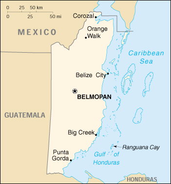
Capital: Belmopan
Currency: 1 Belizean dollar (Bz$) = 100 cents
Geography of Belize
Location: Middle America, bordering the Caribbean Sea, between Guatemala and Mexico
Geographic coordinates: 17 15 N, 88 45 W
Map references: Central America and the Caribbean
Area:
total: 22,960 sq. km
land: 22,800 sq. km
water: 160 sq. km
Land boundaries:
total: 516 km
border countries: Guatemala 266 km, Mexico 250 km
Coastline: 386 km
Maritime claims:
exclusive economic zone: 200 nm
territorial sea: 12 nm in the north, 3 nm in the south; note – from the mouth of the Sarstoon River to Ranguana Cay, Belize’s territorial sea is 3 nm; according to Belize’s Maritime Areas Act, 1992, the purpose of this limitation is to provide a framework for the negotiation of a definitive agreement on territorial differences with Guatemala
Climate: tropical; very hot and humid; rainy season (May to February)
Terrain: flat, swampy coastal plain; low mountains in south
Elevation extremes:
lowest point: Caribbean Sea 0 m
highest point: Victoria Peak 1,160 m
Natural resources: arable land potential, timber, fish, hydropower
Land use:
arable land: 10%
permanent crops: 1%
permanent pastures: 2%
forests and woodland: 84%
other: 3% (2000 est.)
Irrigated land: 20 sq. km (1993 est.)
Natural hazards: frequent, devastating hurricanes (September to December) and coastal flooding (especially in south)
Environment – current issues: deforestation; water pollution from sewage, industrial effluents, agricultural runoff; solid waste disposal
Environment – international agreements:
party to: Biodiversity, Climate Change, Desertification, Endangered Species, Hazardous Wastes, Law of the Sea, Ozone Layer Protection, Ship Pollution, Wetlands
signed, but not ratified: none of the selected agreements
Geography – note: only country in Central America without a coastline on the North Pacific Ocean
Belize is located on the Caribbean coast of northern Central America. It shares a border on the north with the Mexican state of Quintana Roo, on the west with the Guatemalan department of Petén, and on the south with the Guatemalan department of Izabal. To the east in the Caribbean Sea, the second-longest barrier reef in the world flanks much of the 386 kilometers of predominantly marshy coastline. Small cay islands totaling about 690 square kilometers, dot the reef. The area of the country totals 22,960 square kilometers, an area slightly larger than El Salvador or Massachusetts. The abundance of lagoons along the coasts and in the northern interior reduces the actual land area to 21,400 square kilometers.
Belize is shaped like a rectangle that extends about 280 kilometers north-south and about 100 kilometers east-west, with a total land boundary length of 516 kilometers. The undulating courses of two rivers, the Hondo and the Sarstoon, define much of the course of the country’s northern and southern boundaries. The western border follows no natural features and runs north-south through lowland forest and highland plateau.
Geology
Belizean geology consists largely of varieties of limestone, with the notable exception of the Maya Mountains, a large intrusive block of granite and other Paleozoic sediments running northeast to southwest across the south-central part of the country. Several major faults rive these highlands, but much of Belize lies outside the tectonically active zone that underlies most of Central America. During the Cretaceous period, what is now the western part of the Maya Mountains stood above sea level, creating the oldest land surface in Central America, the Mountain Pine Ridge plateau.
The hilly regions surrounding the Maya Mountains are formed from Cretaceous limestone. These areas are characterized by a karst topography that is typified by numerous sinkholes, caverns, and underground streams. In contrast to the Mountain Pine Ridge, some of the soils in these regions are quite fertile and have been cultivated during at least the past 4,000 years.
Much of the northern half of Belize lies on the Yucatán Platform, a tectonically stable region. Although mostly level, this part of the country also has occasional areas of hilly, karst terrain, such as the Yalbac Hills along the western border with Guatemala and the Manatee Hills between Belize City and Dangriga. Alluvial deposits of varying fertility cover the relatively flat landscapes of the coastal plains.
Physical Features
Topographical features divide the Belizean landscape into two main physiographic regions. The most visually striking of these regions is distinguished by the Maya Mountains and the associated basins and plateaus that dominate all but the narrow coastal plain in the southern half of the country. The mountains rise to heights of about 1,100 meters, with the highest point being Victoria Peak (1,120 meters) in the Cockscomb Mountains. Covered with shallow, highly erodible soils of low fertility, these heavily forested highlands are very sparsely inhabited.
The second region comprises the northern lowlands, along with the southern coastal plain. Eighteen major rivers and many perennial streams drain these low-lying areas. The coastline is flat and swampy, with many lagoons, especially in the northern and central parts of the country. Westward from the northern coastal areas, the terrain changes from mangrove swamp to tropical pine savannah and hardwood forest.
The interlocking networks of rivers, creeks, and lagoons have played a key role in the historical geography of Belize. The largest and most historically important river is the Belize, which drains more than one-quarter of the country as it winds along the northern edge of the Maya Mountains across the center of the country to the sea near Belize City. Also known as the Old River, the Belize River is navigable up to the Guatemalan border and served as the main artery of commerce and communication between the interior and the coast until well into the twentieth century. Other historically important rivers include the Sibun, which drains the northeastern edge of the Maya Mountains, and the New River, which flows through the northern sugar-growing areas before emptying into Chetumal Bay. Both of these river valleys possess fertile alluvial soils and have supported considerable cultivation and human settlement.
Natural Resources
Although a number of economically important minerals exist in Belize, none has been found in quantities large enough to warrant their mining. These minerals include dolomite, barite (source of barium), bauxite (source of aluminum), cassite (source of tin), and gold. In 1990 limestone, used in roadbuilding, was the only mineral resource being exploited for either domestic or export use.
The similarity of Belizean geology to that of oil-producing areas of Mexico and Guatemala prompted oil companies, principally from the United States, to explore for petroleum at both offshore and on-land sites in the early 1980s. Initial results were promising, but the pace of exploration slowed later in the decade, and production operations never commenced. As a result, Belize remains almost totally dependent on imported petroleum for its energy needs. However, the country does possess considerable potential for hydroelectric and other renewable energy resources, such as solar and biomass. In the mid-1980s, one Belizean businessman even proposed the construction of a wood-burning power station for the production of electricity, but the idea foundered in the wake of ecological concerns and economic constraints.
Climate
Belize has a tropical climate with pronounced wet and dry seasons, although there are significant variations in weather patterns by region. Temperatures vary according to elevation, proximity to the coast, and the moderating effects of the northeast trade winds off the Caribbean. Average temperatures in the coastal regions range from 24° C in January to 27° C in July. Temperatures are slightly higher inland, except for the southern highland plateaus, such as the Mountain Pine Ridge, where it is noticeably cooler year round. Overall, the seasons are marked more by differences in humidity and rainfall than in temperature.
Average rainfall varies considerably, ranging from 1,350 millimeters in the north and west to over 4,500 millimeters in the extreme south. Seasonal differences in rainfall are greatest in the northern and central regions of the country where, between January and April or May, fewer than 100 millimeters of rain fall per month. The dry season is shorter in the south, normally only lasting from February to April. A shorter, less rainy period, known locally as the “little dry,” usually occurs in late July or August, after the initial onset of the rainy season.
Hurricanes have played key–and devastating–roles in Belizean history. In 1931 an unnamed hurricane destroyed over two-thirds of the buildings in Belize City and killed more than 1,000 people. In 1955 Hurricane Janet leveled the northern town of Corozal. Only six years later, Hurricane Hattie struck the central coastal area of the country, with winds in excess of 300 kilometers per hour and four-meter storm tides. The devastation of Belize City for the second time in thirty years prompted the relocation of the capital some eighty kilometers inland to the planned city of Belmopan. The most recent hurricane to devastate Belize was Hurricane Greta, which caused more than US$25 million in damages along the southern coast in 1978.
People of Belize
Belize is the most sparsely populated nation in Central America; it is larger than El Salvador and compares in size to the state of Massachusetts. Slightly more than half of the people live in rural areas. About one-fourth live in Belize City, the principal port, commercial center, and former capital.
Most Belizeans are of multiracial descent. About 46.4% of the population is of mixed Mayan and European descent (Mestizo); 27.7% are of African and Afro-European (Creole) ancestry; about 10% are Mayan; and about 6.4% are Afro-Amerindian (Garifuna). The remainder, about 9.5%, includes European, East Indian, Chinese, and Middle Eastern and North American groups.
English, the official language, is spoken by virtually all except the refugees who arrived during the past decade. Spanish is the native tongue of about 50% of the people and is spoken as a second language by another 20%. The various Mayan groups still speak their original languages, and an English Creole dialect (or “Kriol” in the new orthography), similar to the Creole dialects of the English-speaking Caribbean Islands, is spoken by most. The rate of functional literacy is 76%. About 60% of the population is Roman Catholic; the Anglican Church and Protestant Christian groups account for most of the remaining 40%. Mennonite settlers number about 7,160.
Population: 279,457 (July 2005 est.)
Age structure:
0-14 years: 42.04%
15-64 years: 54.43%
65 years and over: 3.53% (2001 est.)
Population growth rate: 2.7%
Birth rate: 31.69 births/1,000 population
Death rate: 4.7 deaths/1,000 population
Net migration rate: 0 migrant(s)/1,000 population
Infant mortality rate: 25.14 deaths/1,000 live births
Life expectancy at birth:
total population: 71.19 years
male: 68.91 years
female: 73.57 years
Total fertility rate: 4.05 children born/woman
Nationality:
noun: Belizean(s)
adjective: Belizean
Ethnic groups: mestizo 43.7%, Creole 29.8%, Maya 10%, Garifuna 6.2%, other 10.3%
Religions: Roman Catholic 62%, Protestant 30% (Anglican 12%, Methodist 6%, Mennonite 4%, Seventh-Day Adventist 3%, Pentecostal 2%, Jehovah’s Witnesses 1%, other 2%), none 2%, other 6% (1980)
Languages: English (official), Spanish, Mayan, Garifuna (Carib), Creole
Literacy:
definition: age 15 and over can read and write
total population: 70.3%
male: 70.3%
female: 70.3% (1991 est.)
note: other sources list the literacy rate as high as 75%
Perhaps the most pronounced feature of the Belizean population, aside from its ethnic heterogeneity, is its small size. In 1980 the population was estimated at approximately 145,000. Slightly more than 50 percent of the people resided in eight urban areas, with more than 30 percent in Belize City. By 1990, the pattern of population distribution had changed, with 51.8 percent of the approximately 191,000 Belizeans living in rural areas. The growth in the rural population during the 1980s stemmed primarily from the influx of Central American immigrants who moved to Belize’s countryside. Meanwhile, many urban Belizeans moved to the United States and elsewhere. Even with the increase in its overall population, Belize remained one of the least densely populated countries in the Americas, averaging 8.5 persons per square kilometer in 1991.
Belize is divided administratively into six districts: Corozal, Orange Walk, Belize, Cayo, Stann Creek, and Toledo. In 1991, more than one in three Belizeans lived in Belize District (including Belize City), which had a population density five times greater than the least populated district, Toledo.
As in many other developing societies, the Belizean population was unevenly divided by age and gender. The ratio of males and females in the population varied considerably over the last century. In the 1980s, males outnumbered females in most age groups. Shifts in the gender ratio have generally been attributed to changing migration patterns. In the 1940s and 1950s the emigration stream was predominantly male, but recently, women emigrants outnumbered men.
Consistent with the demographic profile of most developing nations was the general youthfulness of the Belizean population. In 1990 some 46 percent of Belizeans were fourteen years of age or younger and some 58 percent were under the age of twenty. Regular declines in the death rate have steadily increased the proportion of the population sixty-five years of age and older, to 4.6 percent in 1980.
The average crude birthrate for Belize experienced slow but steady decline, from 44.1 per 1,000 population in 1963 to 35.0 per 1,000 in 1990. The average fertility rate also dropped from nearly 7 children per woman in the late 1960s to 5.4 in 1985. Coupled with declining death and infant mortality rates, the high birthrate between 1970 and 1980 indicated a potential population increase of more than 3.0 percent for the decade. However, the actual increase between 1970 and 1980 was only 1.9 percent, indicating a very high rate of emigration, perhaps involving as many as one in every eight Belizeans. During the 1980s, the rate of natural population increase was about 3.0 percent for the decade. The difference between projected and actual population increase for the period 1980-1990 was considerably less than in the 1970s, as the actual rate of increase was some 2.4 percent. The closer correspondence of these two figures reflected not so much a decline in emigration by Belizeans, as the scale and demographic impact of the immigration from the surrounding Central American republics.
Migration
Continuous migration has made it difficult to determine accurately the size and social composition of the Belizean population and to project future growth. Although small numbers of Belizeans have emigrated to Britain, Canada, and the West Indies, the principal destination of most Belizean emigrants has been the United States. Estimates of the Belizean population in the United States have varied between 30,000 and 100,000. The United States Embassy in Belize has estimated that in 1984, about 55,000 Belizeans were residing in the United States, with two of three living there illegally. Settling primarily in New York City, Los Angeles, Chicago, Miami, and New Orleans, most of these emigrants were either Creole or Garifuna. Their remittances, estimated at US$11 million in 1984, played an important role in the subsistence of many Belizean households, especially in Belize City and Dangriga. Later estimates were that as many as 65,000 Belizeans were living in the United States by mid-1988, with the majority ranging in age from twenty to thirty-four.
Estimates of the immigrant population in Belize also varied widely. According to the 1980 census, more than 10 percent of the population, or roughly 15,000 people, were born in other countries. One of two immigrants came from either Guatemala, Mexico, Honduras, or El Salvador. By the late 1980s, these figures were considerably higher because immigration continued, albeit on a lesser scale, over the course of the decade. The percentages of immigrants who were from Mexico and Central America, the numbers of foreign-born refugees, and the numbers of Belizeans who had been born in other countries all increased. The number of Salvadoran refugees living in Belize was estimated at between 2,000 and 15,000 in the late 1980s, and recent studies claim that between 25,000 and 31,000 citizens of neighboring republics had entered the country since 1977.
The presence of these “aliens,” as they were popularly known, was visible in Belize. As of 1991, Salvadoran and Guatemalan vendors lined the sidewalks of Belize City’s main commercial street and were prominent in the marketplaces of Orange Walk, Dangriga, and especially the capital, Belmopan. Belizeans derisively dubbed a recently developed satellite shantytown in Belmopan as “Salvapan.” Along the remote Hummingbird and Southern highways, the fields of the new migrants cut dramatic swaths in the previously uninhabited forest. This situation raised environmentalists’ concerns about soil erosion. Although Central American immigrants have settled throughout the country, they have been most heavily concentrated in the rural areas of Cayo and Toledo districts.
The emigration of English-speaking Creoles and Garifuna to the United States and the immigration of Spanish-speaking Mestizos from Central America exacerbated ethnic tensions and challenged long-held assumptions regarding the character of Belizean culture, which has traditionally been oriented toward the English-speaking Caribbean. Although they comprised only 40 percent of the total population in 1980, Creoles long considered Belize “their” country–black, English-speaking, and Protestant. Moreover, Guatemala’s persistent claim to Belize’s territory caused many Belizeans, especially Creoles, to be antagonistic toward Hispanic culture. A key problem in the drive toward building the Belizean nation was the substitution of an ideology of cultural pluralism for undisputed Creole cultural dominance. Neither educational efforts nor political rhetoric has been completely successful in this regard. Indeed, by the early 1990s, many Belizeans were apprehensive of increasing ethnic tension.
Ethnicity
The most salient characteristic of Belizean society in the late 1980s was ethnic diversity. Ethnicity in Belize was not reduced to race, but instead referred to the collective identities formed through a complex interplay of racial, linguistic, and religious factors, as well as a sense of shared history and custom.
The two largest ethnic groups together constituted almost three-quarters of the population. The 1980 census listed 39.7 percent of the population as Creole, a group usually defined as English speakers descended wholly or in part from African slaves imported to work in the colonial mahogany industry. The 1980 census combined the previously separate “black” and “coloured” segments of the population into a single group. Consequently, there was considerable physical diversity among people listed as Creole. A folk system of racial classification further hierarchically divided Creoles on the basis of such physical features as skin shade, facial features, and hair texture. Despite political independence, the colonial social bias toward “clear” or light skin and European features endured in contemporary Belizean society.
The second largest group, comprising one-third of the population, was identified as Mestizos, or persons of mixed Hispanic-Amerindian origin. In the local Creole vernacular, the Mestizos were known as “Spanish.” The physical appearance of the Mestizos varied but not to the extent that it varied among Creoles. Most Belizean Mestizos were descended from refugees of the midnineteenth -century Caste War of Yucatán. The majority of them settled in the northern districts of Corozal and Orange Walk, where they initiated the cultivation of sugarcane in Belize.
Migration during the 1980s had a major impact on the demographic balance between the two largest ethnic groups. As of 1991, the government had not released figures on ethnic identity from the 1990 census, but census officials predicted that Mestizos would equal or outnumber Creoles.
The third largest ethnic population comprised three distinct groups: the Yucatecan, Mopán, and Kekchí Maya. In 1980 one in ten Belizeans belonged to one of the three groups. Belizeans commonly referred to the Yucatecan and Mopán peoples as Maya. Contrary to the statements of colonial historians, some of these Mayan peoples were indeed descendants of the inhabitants of pre-Columbian Belize. Most Kekchí and Mopán, however, emigrated from Guatemala in the late nineteenth century.
The Garifuna, formerly known as the Black Carib, were Belize’s fourth largest ethnic grouping, constituting 7 percent of the population in 1980. Descended from African slaves who intermarried with Amerindian inhabitants of the eastern Caribbean islands, the Garifuna were deported to the Gulf of Honduras by the British in the late eighteenth century. Some Garifuna migrated to the southern Belizean coast, where they established five major settlements. Initially fishermen and subsistence farmers, the Garifuna were gradually incorporated into wage labor in the mahogany industry as early as the 1820s, and later on in the banana and citrus plantations that developed in the Stann Creek Valley and elsewhere in the early twentieth century. Over the course of the twentieth century, an increasing number of Garifuna men became migrant workers, first along the Caribbean coast of Central America, and later in the United States.
Smaller ethnic groups–East Indians (whose forebears came from present-day India), Arabs, Chinese, and Euro-Americans, including a sizeable community of German-speaking Mennonites–made up the remaining 10 present of Belize’s population. Of these groups, the East Indian population was the largest. They were largely descendants of nineteenth-century indentured laborers imported to work the sugar plantations of the Corozal and Toledo districts. By the late 1980s, they had intermarried extensively with other ethnic groups, and for the most part, they no longer possessed an identifiably East Indian culture. They lived in all of the country’s six districts, but were concentrated in Toledo.
There was a second, and much smaller, East Indian community in Belize, composed of Hindi-speaking traders who immigrated to Belize from Bombay in the 1960s. Living primarily in Belize City and Orange Walk, they formed an aloof, close-knit community that, by the late 1980s, dominated Belize City retail trade and played a major role in currency exchange and speculation.
The smallest ethnic groups–Arabs and Chinese–were also exclusively urban, mercantile populations. Known variously as Turks, Syrians, and Lebanese, many Belizean Arabs were actually Palestinian. Immigrating to Belize in the late nineteenth and early twentieth centuries, they figured prominently as merchants in the Belize and Cayo districts.
A significant number of Chinese were imported as contract laborers in the nineteenth century, but virtually all Chinese people living in Belize today came to the country in the twentieth century. Most resided in Belize City, but at least a few Chinese families lived in every major town. Some were merchants but most worked in the restaurant and lottery industries. In the late 1980s, the Chinese population increased dramatically with immigration from Hong Kong and Taiwan.
Belize’s small, German-speaking Mennonite population emigrated from Mexico between 1958 and 1962. Numbering more than 5,000, the Mennonites founded numerous settlements in the Orange Walk, Cayo, and Toledo districts. The government granted them complete autonomy over their communities. Nevertheless, they have been slowly integrated into the life of the nation, particularly into the economy. The more progressive Mennonites of Spanish Lookout (Cayo District) and Blue Creek (Orange Walk District) became important suppliers of poultry, eggs, dairy products, and furniture. Still, they remained exempt from military service and were not allowed to vote.
Aside from the Mennonites, the majority of Belize’s small white population were British and United States expatriates. Unlike some other Caribbean societies, Belize never supported a large European settler community during the colonial period. Since independence, a large, transient population of United States and British volunteers and international aid personnel has augmented the local European population. In 1986 the United States Peace Corps alone had more than 200 volunteers, the corps’s highest volunteer-to- population ratio in the world. By 1991, however, the number of Peace Corps volunteers had dropped to less than 100.
The distribution of officially recognized ethnic groups was highly skewed by region, and each district had its own characteristic cultural orientation. Creoles made up three-quarters of the population of Belize City and the surrounding area but no more than one-third of the population in the other five districts. Mestizos constituted two-thirds of the people in the northern sugar-producing districts of Orange Walk and Corozal, one-half the population of the predominantly agricultural Cayo district, but only about one-tenth of the population in Belize, Stann Creek, and Toledo. Garifuna lived mostly along the coasts of the two southernmost districts of Stann Creek and Toledo; they made up fewer than 3 percent of the population in any of the other four districts. The majority of the country’s diverse Mayan population resided mainly in the interior of Toledo (where they constituted some 57 percent of the district’s people) and the rural areas of Stann Creek, Orange Walk, and Corozal.
History of Belize
GUYANA AND BELIZE belie their geographic location. Although both are located on the mainland of the Americas, they more closely resemble the English-speaking islands of the Caribbean than they do their Latin American neighbors. Christopher Columbus passed near the coasts of both countries, but later Spanish explorers and settlers ignored the areas because they lacked the mineral riches that brought the Spanish to the New World. The wealth of both areas would prove to be not gold but agriculture. By the end of the eighteenth century, the indigenous populations of both regions had been greatly reduced or driven to remote areas, and the coastal lands held growing populations of British or Dutch plantation owners. Plantation work was labor intensive, and initially African slaves, then other ethnic groups, were imported to work the land. As the colonies expanded economically, the United Kingdom claimed formal sovereignty, but title to each colony remained contested.
The twentieth century saw a shift in political power from the old plantocracy to a new nonwhite middle class, a rising self- consciousness among the various ethnic groups, and a slow evolution toward independence. Formal ties to the United Kingdom eventually were broken, but, like their anglophone Caribbean neighbors, Guyana and Belize today still strongly bear the mark of their colonial heritage. They retain their British institutions, their use of the English language, their economies based on agriculture, and their societies composed of a complex ethnic mix often divided along racial lines.
Unlike the great civilizations of Middle America that left monuments and records for archaeologists to decipher, the early societies in Guyana were relatively simple, nomadic cultures that left few traces. Early Spanish records and linguistic studies of the Caribbean reveal only a broad outline of pre-Columbian events. We do know that several centuries before the arrival of the Europeans, the Arawak moved north from Brazil to settle and farm the area along the northeast coast of South America before expanding farther north onto the Caribbean islands. Shortly before the arrival of the Europeans, the aggressive, warlike Carib pushed into the area and largely destroyed Arawak society.
Because of the warlike Carib and the region’s apparent lack of gold or silver, the Spanish ignored the northeastern coast of South America. Settlement by Europeans would wait until 1616, when a group of Dutch arrived to establish a trading post. The Dutch soon realized the agricultural potential of the swampy coastal land and aggressively set out to drain the coast using a vast system of seawalls, dikes and canals. What had been swampy wasteland decades before, soon turned into thriving sugar plantations.
The development of agriculture brought rapid change to the colony. Because the plantation economy needed labor, the Dutch imported African slaves for the task. The growing economy also attracted the attention of the British, and British settlers from neighboring Caribbean islands poured into the three Dutch colonies established along the coast. By the late 1700s, the new British settlers effectively controlled the colonies. Formal control by the United Kingdom would come in 1814, when most Dutch colonies were ceded to the United Kingdom after the Napoleonic wars.
In 1838 the United Kingdom completed the abolition of slavery throughout the their Empire, and the problem of obtaining cheap and plentiful labor arose anew. The planters first sought to attract Portuguese, then Chinese, workers, but both groups soon left plantation work. Concerned that the decline in labor would ruin the sugar-based economy, the planters finally contracted laborers from India to work the sugar fields. Large numbers of indentured workers poured into British Guiana in the late 1800s. Although theoretically free to return after their contract period had expired, most East Indians remained, adding a new ethnic group to the colony’s mélange of Africans, Europeans, and Amerindians.
The twentieth century saw a rising consciousness among the country’s ethnic groups and a struggle for political power between the new, disenfranchised, nonwhite middle class and the old plantocracy. Economic changes gave momentum to the growing call for political changes. The country saw rice production, dominated by the Indo-Guyanese (descendants of East Indians), and bauxite mining, dominated by the Afro-Guyanese (descendants of Africans), grow in importance, whereas sugar growing, controlled by the European plantation owners, declined. The British colonial administration responded to demands for reform by establishing universal suffrage in 1950 and allowing the formation of political parties.
The People’s Progressive Party (PPP), the country’s first political party, quickly became a formidable force. The PPP was formed by two men who would dominate Guyanese politics for decades to come: Cheddi Jagan, a Marxist Indo-Guyanese, and Linden Forbes Burnham, an Afro-Guyanese with leftist political ideas. A new constitution allowing considerable self-rule was promulgated in 1953; in elections that year the PPP, headed by Jagan, won a majority of seats in the new legislature. The new administration immediately sought legislation giving the labor unions expanded power. This legislation and the administration’s leftist rhetoric frightened the British colonial authorities, who suspended the new government after only four months.
Conflict with the British was not the only problem facing the PPP. Personal rivalries between Jagan and Burnham and growing conflict between the Indo-Guyanese and the Afro-Guyanese widened into an open split. In 1957 Burnham and most of the Afro-Guyanese left the PPP and formed the rival People’s National Congress (PNC). The two parties shared left-wing ideologies; the differences between them were largely based on ethnicity.
The British promulgated a new constitution in 1957. Elections in that year and in 1961 resulted in more PPP victories. Under the new constitution, considerable power resided in the hands of the governor, who was appointed by the British. The PPP administration headed by Jagan was therefore unable to implement most of its radical policy initiatives. The Marxist rhetoric, however, intensified.
Convinced that independence under a PPP administration would result in a communist takeover, the British authorities permitted and even encouraged a destabilization campaign by the opposition PNC. Antigovernment demonstrations and riots increased and in 1963 mobs destroyed parts of Georgetown, the capital. When labor unrest paralyzed the economy, British troops were called in to restore order. In the midst of the unrest the government scheduled new elections in 1964.
Voting along ethnic lines again gave the PPP the largest number of seats in the legislature. But the rival PNC, by allying itself with a small business-oriented party, was able to form a coalition government. Jagan had to be forcibly removed as prime minister, and in December 1964 Burnham assumed the post. Under the new administration, events stabilized, and independence was set for May 26, 1966.
The independent Guyana inherited by the PNC was one of the least-populated and least-developed countries in South America. Located on the northeast coast of the continent just north of the equator, the Idaho-sized country is wedged among Venezuela, Brazil, and Suriname (former Dutch Guiana). More than 90 percent of the population lives within five or six kilometers of the sea. This coastal plain, constituting only 5 percent of the country’s total area, was originally low swampland but was transformed by the Dutch into the country’s most productive agricultural land. Inland from the coastal plain lies the white-sand belt, site of most of Guyana’s mineral wealth of bauxite, gold, and diamonds. Farther inland are the interior highlands, consisting of largely uninhabited mountains and savannahs.
Guyana’s ethnic mix at independence, still the same in 1993, consisted primarily of Indo-Guyanese–about half the population– and Afro-Guyanese–slightly more than 40 percent of the total. Smaller numbers of Amerindians, Asians, and Europeans completed Guyana’s ethnic mélange. More than two-thirds of the population was Christian, with significant Hindu and Muslim minorities. Established by the British, the school system has resulted in high literacy rates (more than 90 percent).
The small military, the Guyana Defence Force, existed primarily as a deterrent to Venezuela’s territorial claim. Venezuela’s claim to the western three-fifths of Guyana, a dispute that dated from the colonial era, was thought to have been settled by arbitration in 1899. When later evidence showed that one of the judges had been influenced to vote against Venezuela, that country declared the arbitration settlement invalid and in the 1960s aggressively pursued its territorial claim on western Guyana. This border dispute was to flare periodically after Guyana’s independence.
The first years of PNC administration after independence saw Prime Minister Burnham vigorously establishing control over Guyana’s political and economic life. The 1968 elections were won by the PNC, despite charges of widespread fraud and coercion of voters. As the government’s control over the country’s political institutions increased, Burnham began nationalizing industries and financial institutions. In 1970 Guyana was declared a “cooperative republic,” and government control of all economic activity increased. The 1973 elections were considered the most undemocratic in Guyana’s history, and by 1974 all organs of the state had become agencies of the ruling PNC.
In the late 1970s, a number of events increased opposition to the Burnham regime. The economy, which had grown immediately after independence, began to contract because of nationalization. In addition, in 1978 negative international attention was focused on Guyana when more than 900 members of the People’s Temple of Christ led by Jim Jones committed mass murder and suicide at their community in western Guyana. As opposition to the government increased, the government responded by violence against opposition members and meetings. The authoritarian nature of the Burnham government caused the loss of both foreign and domestic supporters.
A new constitution was promulgated in 1980, shifting power from the prime minister to the new post of executive president, but the political and economic situation continued to decline. Government programs had been financed by increasing the foreign debt, but in the early 1980s, most foreign banks and lending organizations refused further loans. The quality of life deteriorated: blackouts were frequent, and shortages of rice and sugar, Guyana’s two largest crops, appeared. In 1985 in the midst of this turbulence, Burnham died while undergoing throat surgery.
Vice President Hugh Desmond Hoyte became the country’s new executive president. He had two stated goals: to secure political power and revitalize the economy. Establishing political control was easy. The PNC chose Hoyte as its new leader, and in the 1985 elections the PNC claimed more than 79 percent of the vote. Economic growth, however, would require concessions to foreign lenders. Hoyte therefore began to restructure the economy. An economic recovery plan was negotiated with the International Monetary Fund and the World Bank allowing for new loans in exchange for free-market reforms and reversal of the Burnham administration’s nationalization policies. To win favor with Western governments and financial institutions, Hoyte also moderated the previous administration’s leftist tilt in international relations.
The results of economic reform were slow to appear, but by 1990 the economy began to grow again. The last legitimate date for new elections was December 1990. Sensing, however, that the PNC might be able to win a fair election (and thus regain a measure of international respect) if the economy continued to improve, the government invoked a clause in the constitution allowing elections to be postponed a year. Seeing a chance for an honest election, a group of Guyanese civic leaders created the Elections Assistance Board (EAB) to monitor the upcoming elections. The EAB appealed to the Carter Center in Atlanta for international support in its effort.
Despite threats and intimidation, in July 1991 the EAB conducted a door-to-door survey to verify voter lists. When the lists were shown to be grossly inaccurate, the Hoyte administration, under pressure from the EAB and the international community, declared a state of emergency and agreed to postpone the elections until October 1992 and implement a series of reforms suggested by the Carter Center. The reforms included appointment of a new election commissioner and agreement that the ballots be counted at polling centers in view of poll watchers instead of being taken to government centers and army bases for tallying.
The election date was finally set for October 5, 1992. Hoyte based the PNC campaign on the improving economy, which he credited to his free-market reforms. The PPP, still headed by Jagan after forty-two years, renounced its past Marxist policies and embraced elements of a free-market economy. In a reversal of decades of racial politics, Jagan attempted to downplay the country’s ethnic polarization by naming an Afro-Guyanese, Sam Hinds, as his running mate.
Monitored by an international team of observers headed by United States former President Jimmy Carter, election results gave an alliance of the PPP, the smaller Working People’s Alliance (WPA), and the United Force (UF) 54 percent of the vote, and the PNC, 45 percent. These results translated into thirty-two seats in the National Assembly for the PPP, thirty-one seats for the PNC, and one apiece for the WPA and the UF. Foreign observers certified the elections as “free, fair, and transparent.” The PNC conceded defeat on October 7 and, after twenty-eight years, stepped down from power. Following brief consultations, the PPP formed a coalition government with the WPA and the UF (named the PPP-Civic coalition) and named Jagan executive president.
Two days of rioting and looting in Georgetown and Linden in eastern Guyana followed announcement of the election results. By the time the army and police restored order, 2 demonstrators had been killed and more than 200 injured. Many analysts attributed the violence to the fear that a PPP government would mean fewer economic benefits for the Afro-Guyanese population. Former President Carter, however, stated that the violence was localized and the looting unrelated to the voting.
In a radio broadcast on October 13, Jagan outlined the direction of the new government. He stated his intention to build a political consensus that cut across ethnic lines and to continue the privatization policies of his predecessor. Analysts speculated that the new administration would have difficulty in getting measures approved by the National Assembly and would face strong opposition from the PNC-dominated military and civil service. Election observers noted also the need to lower racial tension in a society that some characterized as one of the most racially divided they had witnessed. The motto on the Guyanese coat of arms proudly proclaims “one people, one nation, one destiny.” In 1993, however, this motto remained a distant goal.
The history of preindependence Belize parallels in many ways the history of Guyana. Unlike the pre-Columbian inhabitants of Guyana, however, the Maya in Belize left majestic ruins of their civilization. Remains of the earliest settlers of the area date back at least to 2500 B.C. By 250 A.D. the classic period of Maya culture had begun; this period of city-building lasted for more than 700 years. During this time, the Maya built big ceremonial centers, practiced large-scale agriculture using irrigation, and developed writing and a sophisticated calendar. Around the tenth century, evidence suggests that the great cities were abandoned, perhaps because of increased warfare among the city-states, revolt of the peasants against the priestly class, overexploitation of the environment, or a combination of these and other factors. Even though the great ceremonial centers were left to decay, the Maya continued to inhabit the region until the arrival of the Europeans.
The first European settlers in the area were not Spanish but English. Although Christopher Columbus passed through the area on his fourth voyage to the Americas in 1502, Spanish explorers and settlers ignored the region because it lacked gold. English pirates roaming the Caribbean in the seventeenth century began establishing small camps near the Belize River to cut logwood, from which a black dye was extracted. Logwood extraction proved more profitable than piracy, and the English settlements on the Caribbean coast grew.
The Spanish sent expeditions throughout the eighteenth century to dislodge the British settlers. The British were repeatedly forced to evacuate but returned shortly after each attack. Several treaties in the late 1700s recognized the British settlers’ right to extract logwood but confirmed Spanish sovereignty over the region, a concession that later would lead to a territorial dispute.
The colony continued to grow throughout the nineteenth century. Logwood extraction was replaced by mahogany cutting as the settlement’s principal economic activity, and slaves were introduced to increase production. By the time emancipation was completed in 1838, the settlement had evolved into a plantation society with a small number of European landowners and a large population of slaves from Africa.
In the nineteenth century, the colony was also a magnet for dispossessed groups throughout the region. The Garifuna, an Afro-indigenous people descended from the Carib Indians and slaves of the Eastern Caribbean, found refuge in the area in the early 1800s. In the mid- and late 1800s, large numbers of Maya, many of whom had intermarried with or become culturally assimilated to the Spanish-speaking population of Central America, fled fighting in the Yucatán or forced labor in Guatemala and settled in the colony.
The nineteenth century also saw the development of formal government. As early as 1765, a common law system for the settlers was formalized, and a superintendent was named in 1794. A rudimentary legislature began meeting in the early 1800s, and in 1854 the British produced a constitution and formally established the colony of British Honduras in 1862. Political power in the colony remained firmly in the hands of the old settler elite, however; blacks working the plantations were disenfranchised, and smaller populations of smallholder Garifuna and Maya lived on the periphery of society.
The early 1900s were a period of political and social change. Nonwhite groups, particularly an emerging black middle class, began to agitate for the vote and political power. Mahogany production slowed, and the colony began to depend on sugar for revenue. Additional immigrants from neighboring Spanish-speaking countries drifted in and settled among the rural Maya. Creoles, as the English-speaking blacks called themselves, began to participate in colonial politics.
The Great Depression of the 1930s greatly accelerated the pace of change. Mahogany exports virtually collapsed, and the colonial officials responded with measures designed primarily to protect the interests of the plantation owners. As a result, widespread labor disturbances broke out. Pressured by persistent labor unrest, the government eventually legalized trade unions in 1941. The unions soon broadened their demands to include political reform, and in 1950 the first and most durable political party, the People’s United Party (PUP), was formed with strong backing from the labor movement. Universal suffrage was granted to literate adults in 1954, and by the 1960s the colony was being prepared for independence.
The final obstacle to independence proved to be not internal problems or resistance from the colonial power, but an unresolved territorial claim over all of Belize by neighboring Guatemala. The dispute dated to treaties signed in the 1700s, in which the United Kingdom agreed to Spanish sovereignty over the region. Guatemala later claimed it had inherited Spanish sovereignty over Belize. Although negotiations over the issue had occurred periodically for more than a century, the matter of sovereignty became a particularly important issue for Guatemala in the 1960s and 1970s, when it realized the United Kingdom might grant independence to Belize.
Guatemala’s demand for annexation of Belize was largely fought in the international area. Realizing that Belize’s small defense force of 700 was no match for Guatemala’s army, the British stationed a garrison force to deter any aggression. Belize sought support for sovereignty from the United Nations, the Nonaligned Movement, the Commonwealth of Nations, and the Organization of American States. First, individual states and then the international organizations themselves came to support Belize’s cause. By 1980 Guatemala was completely without international support for its territorial claim, and the British granted Belize independence in 1981.
Belize at independence was a small country whose economy depended on one crop. Unlike many other newly emerging nations, however, Belize was underpopulated in the early 1990s. The country, approximately the size of Massachusetts, consists largely of tropical forest, flat in the north and with a low range of mountains in the south. Belize has traditionally depended on one crop (forest products in the 1700s and 1800s; sugar in the mid- 1900s) for its economic livelihood. A collapse in the price of sugar in the 1980s forced the government to diversify the economy. The growth of tourism and increased citrus and banana production in the 1990s made the economy less vulnerable to the price swings of a single commodity.
Ethnic diversity characterized Belizean society. The two largest groups were the Creoles, an English-speaking group either partly or wholly of African descent, and the Hispanic descendants of immigrants from neighboring Spanish-speaking countries or Hispanicized indigenous groups called Mestizos. Smaller groups included the Garifuna and the various Maya peoples. The 1980 census showed the population to be about 40 percent Creole and 33 percent Mestizo. A considerable of influx of people from Central America shifted these percentages, however, so that the 1991 census showed the Mestizos to be the larger group, a change that distanced the country from the anglophone Caribbean and made it increasingly resemble its Hispanic neighbors on the isthmus of Central America.
The British legacy included a parliamentary democracy based on the British model, a government headed by the British monarch but governed by a prime minister named by the lower house of the bicameral legislature, and an independent judiciary. The constitutional safeguards for citizens’ rights were respected, and the two elections since independence had seen power alternate between the country’s two political parties with an absence of irregularities or political violence. The last election in 1989 saw George Cadle Price, leader of the PUP, regain the position of prime minister, a post he had held at the time of independence.
In 1993 Belize faced a number of challenges. The nation endeavored to meet the needs of a growing population with only limited resources. The makeup of the population itself was changing as Belizeans became more like their Central American neighbors and less like the English-speaking Caribbean. Most analysts agreed, however, that as the twentieth century drew to a close, Belize seemed well-positioned to deal successfully with the economic and social changes confronting it.
Belize Economy
Forestry was the only economic activity of any consequence in Belize until well into the 20th century when the supply of accessible timber began to dwindle. Cane sugar then became the principal export and recently has been augmented by expanded production of citrus, bananas, seafood, and apparel. The country has about 809,000 hectares of arable land, only a small fraction of which is under cultivation. To curb land speculation, the government enacted legislation in 1973 that requires non-Belizeans to complete a development plan on land they purchase before obtaining title to plots of more than 10 acres of rural land or more than one-half acre of urban land.
Domestic industry is limited, constrained by relatively high-cost labor and energy and a small domestic market. The embassy knows of some 185 U.S. companies which have operations in Belize, including, Archer Daniels Midland, Texaco, and Esso. Tourism attracts the most foreign direct investment, although significant U.S. investment also is found in the energy, telecommunications, and agriculture sectors.
A combination of natural factors–climate, the longest barrier reef in the Western Hemisphere, numerous islands, excellent fishing, safe waters for boating, jungle wildlife, and Mayan ruins–support the thriving tourist industry. Development costs are high, but the Government of Belize has designated tourism as its second development priority after agriculture. In 2000, tourist arrivals totaled 180,760–more than 110,000 from the U.S.–and tourist receipts amounted to $113.3 million.
GDP: purchasing power parity – $790 million (2000 est.)
GDP – real growth rate: 4% (2000 est.)
GDP – per capita: purchasing power parity – $3,200 (2000 est.)
GDP – composition by sector:
agriculture: 18%
industry: 24%
services: 58% (2000 est.)
Population below poverty line: 33% (1999 est.)
Inflation rate (consumer prices): 2% (2000 est.)
Labor force: 71,000
note: shortage of skilled labor and all types of technical personnel (1997 est.)
Labor force – by occupation: agriculture 38%, industry 32%, services 30% (1994)
Unemployment rate: 12.8% (1999)
Budget:
revenues: $157 million
expenditures: $279 million, including capital expenditures of $NA (1999 est.)
Industries: garment production, food processing, tourism, construction
Industrial production growth rate: 4.6% (1999)
Electricity – production: 185 million kWh (1999)
Electricity – production by source:
fossil fuel: 56.76%
hydro: 43.24%
nuclear: 0%
other: 0% (1999)
Electricity – consumption: 172.1 million kWh (1999)
Electricity – exports: 0 kWh (1999)
Electricity – imports: 0 kWh (1999)
Agriculture – products: bananas, coca, citrus, sugarcane; lumber; fish, cultured shrimp
Exports: $235.7 million (f.o.b., 2000 est.)
Exports – commodities: sugar, bananas, citrus fruits, clothing, fish products, molasses, wood
Exports – partners: US 42%, UK 33%, EU 12%, Caricom 4.8%, Canada 2%, Mexico 1% (1999)
Imports: $413 million (c.i.f., 2000 est.)
Imports – commodities: machinery and transportation equipment, manufactured goods, food, fuels, chemicals, pharmaceuticals
Imports – partners: United States 58%, Mexico 12%, United Kingdom 5% EU 5%, Central America 5%, Caricom 4% (1998)
Debt – external: $338 million (1998)
Currency: 1 Belizean dollar (Bz$) = 100 cents
Map of Belize