Background: A three-year-old Marxist government was overthrown in 1973 by a dictatorial military regime led by Augusto PINOCHET, which ruled until a freely elected president was installed in 1990. Sound economic policies, first implemented by the PINOCHET dictatorship, led to unprecedented growth in 1991-97 and have helped secure the country’s commitment to democratic and representative government. Growth slowed in 1998-99, but recovered strongly in 2000.
Government type: republic
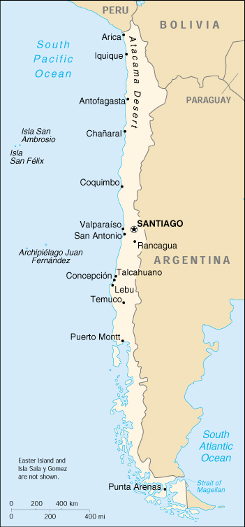
Capital: Santiago
Currency: 1 Chilean peso (Ch$) = 100 centavos
Geography of Chile
Location: Southern South America, bordering the South Atlantic Ocean and South Pacific Ocean, between Argentina and Peru
Geographic coordinates: 30 00 S, 71 00 W
Area:
total: 756,950 sq. km
land: 748,800 sq. km
water: 8,150 sq. km
note: includes Easter Island (Isla de Pascua) and Isla Sala y Gomez
Land boundaries:
total: 6,171 km
border countries: Argentina 5,150 km, Bolivia 861 km, Peru 160 km
Coastline: 6,435 km
Maritime claims:
contiguous zone: 24 nm
continental shelf: 200/350 nm
exclusive economic zone: 200 nm
territorial sea: 12 nm
Climate: temperate; desert in north; Mediterranean in central region; cool and damp in south
Terrain: low coastal mountains; fertile central valley; rugged Andes in east
Elevation extremes:
lowest point: Pacific Ocean 0 m
highest point: Cerro Aconcagua 6,962 m
Natural resources: copper, timber, iron ore, nitrates, precious metals, molybdenum, hydropower
Land use:
arable land: 5%
permanent crops: 0%
permanent pastures: 18%
forests and woodland: 22%
other: 55% (1993 est.)
Irrigated land: 12,650 sq. km (1993 est.)
Natural hazards: severe earthquakes; active volcanism; tsunamis
Environment – current issues: air pollution from industrial and vehicle emissions; water pollution from raw sewage
Environment – international agreements:
party to: Antarctic-Environmental Protocol, Antarctic-Marine Living Resources, Antarctic Seals, Antarctic Treaty, Biodiversity, Climate Change, Desertification, Endangered Species, Environmental Modification, Hazardous Wastes, Law of the Sea, Marine Dumping, Ozone Layer Protection, Ship Pollution, Wetlands, Whaling
signed, but not ratified: Climate Change-Kyoto Protocol, Nuclear Test Ban
Geography – note: strategic location relative to sea lanes between Atlantic and Pacific Oceans (Strait of Magellan, Beagle Channel, Drake Passage); Atacama Desert is one of world’s driest regions
In a classic book on the natural setting and people of Chile, Benjamín Subercaseaux Zañartu, a Chilean writer, describes the country’s geography as loca (crazy). The book’s English translator renders this term as “extravagant.” Whether crazy or extravagant, there is little question that Chile’s territorial shape is certainly among the world’s most unusual. From north to south, Chile extends 4,270 kilometers, and yet it only averages 177 kilometers east to west. On a map, Chile looks like a long ribbon reaching from the middle of South America’s west coast straight down to the southern tip of the continent, where it curves slightly eastward. Cape Horn, the southernmost point in the Americas, where the Pacific and Atlantic oceans turbulently meet, is Chilean territory. Chile’s northern neighbors are Peru and Bolivia, and its border with Argentina to the east, at 5,150 kilometers, is one of the world’s longest.
Chile’s shape was determined by the fact that it began as a Spanish settlement on the western side of the mighty cordillera of the Andes, in the central part of the country. This range, which includes the two tallest peaks in the Americas–Aconcagua (6,959 meters) and Nevado Ojos del Salado (6,880 meters)–is a formidable barrier, whose passes to the Argentine side are covered by a heavy blanket of snow during the winter months. As a result, Chile could expand beyond its original colonial territory only to the south and north. The colony grew southward by occupying lands populated by indigenous groups, and it grew northward by occupying sections of both Peru and Bolivia that were eventually awarded to Chile in the aftermath of the War of the Pacific (1879-83).
The northern two-thirds of Chile lie on top of the telluric Nazca Plate, which, moving eastward about ten centimeters a year, is forcing its way under the continental plate of South America. This movement has resulted in the formation of the Peru-Chile Trench, which lies beyond a narrow band of coastal waters off the northern two-thirds of the country. The trench is about 150 kilometers wide and averages about 5,000 meters in depth. At its deepest point, just north of the port of Antofagasta, it plunges to 8,066 meters. Although the ocean’s surface obscures this fact, most of Chile lies at the edge of a profound precipice.
The same telluric displacements that created the Peru-Chile Trench make the country highly prone to earthquakes. During the twentieth century, Chile has been struck by twenty-eight major earthquakes, all with a force greater than 6.9 on the Richter scale. The strongest of these occurred in 1906 (registering an estimated 8.4 on the Richter scale) and in 1960 (reaching 8.75). This latter earthquake occurred on May 22, the day after another major quake measuring 7.25 on the Richter scale, and covered an extensive section of south-central Chile. It caused a tidal wave that decimated several fishing villages in the south and raised or lowered sections of the coast as much as two meters. The clash between the earth’s surface plates has also generated the Andes, a geologically young mountain range that, in Chilean territory alone, includes about 620 volcanoes, many of them active. Almost sixty of these had erupted in the twentieth century by the early 1990s. More than half of Chile’s land surface is volcanic in origin.
About 80 percent of the land in Chile is made up of mountains of some form or other. Most Chileans live near or on these mountains. The majestically snowcapped Andes and their precordillera elevations provide an ever-present backdrop to much of the scenery, but there are other, albeit less formidable, mountains as well. Although they seemingly can appear anywhere, the non-Andean mountains usually form part of transverse and coastal ranges. The former, located most characteristically in the near north and the far north natural regions, extend with various shapes from the Andes to the ocean, creating valleys with an east-west direction. The latter are evident mainly in the center of the country and create what is commonly called the Central Valley (Valle Central) between them and the Andes. In the far south, the Central Valley runs into the ocean’s waters. At this location, the higher elevations of the coastal range facing the Andes become a multiplicity of islands, forming an intricate labyrinth of channels and fjords that have been an enduring challenge to maritime navigators.
Much of Chile’s coastline is rugged, with surf that seems to explode against the rocks lying at the feet of high bluffs. This collision of land and sea gives way every so often to lovely beaches of various lengths, some of them encased by the bluffs. The Humboldt current, which originates northwest of the Antarctic Peninsula (which just into the Bellingshausen Sea) and runs the full length of the Chilean coast, makes the water frigid. Swimming at Chile’s popular beaches in the central part of the country, where the water gets no warmer than 15° C in the summer, requires more than a bit of fortitude.
Chilean territory extends as far west as Polynesia. The best known of Chile’s Pacific Islands is Easter Island (Isla de Pascua, also known by its Polynesian name of Rapa Nui), with a population of 2,800 people. Located 3,600 kilometers west of Chile’s mainland port of Caldera, just below the Tropic of Capricorn, Easter Island provides Chile a gateway to the Pacific. It is noted for its 867 monoliths (Moais), which are huge (up to twenty meters high) and mysterious, expressionless faces sculpted of volcanic stone. The Islas Juan Fernández, located 587 kilometers west of Valparaíso, are the locale of a small fishing settlement. They are famous for their lobster and the fact that one of the islands, Isla Robinson Crusoe, is where Alexander Selkirk, the inspiration for Daniel Defoe’s novel, was marooned for about four years.
Natural Regions
Chile may have a “crazy” geography, but it is also a land of unparalleled beauty, with an incredible variety that has fascinated visitors since the Spanish conquest. Because Chile extends from a point about 625 kilometers north of the Tropic of Capricorn to a point hardly more than 1,400 kilometers north of the Antarctic Circle, within its territory can be found a broad selection of the earth’s climates. For this reason, geographically it is possible to speak of several Chiles. The country usually is divided by geographers into five regions: the far north, the near north, central Chile, the south, and the far south. Each has its own characteristic vegetation, fauna, climate, and, despite the omnipresence of both the Andes and the Pacific, its own distinct topography.
The Near North
The near north (Norte Chico) extends from the Río Copiapó to about 32° south latitude, or just north of Santiago. It is a semiarid region whose central area receives an average of about twenty-five millimeters of rain during each of the four winter months, with trace amounts the rest of the year. The near north is also subject to droughts. The temperatures are moderate, with an average of 18.5° C during the summer and about 12° C during the winter at sea level. The winter rains and the melting of the snow that accumulates on the Andes produce rivers whose flow varies with the seasons, but which carry water year round. Their deep transverse valleys provide broad areas for cattle raising and, most important, fruit growing, an activity that has developed greatly since the mid-1970s.
As in the for north, the coastal areas of the near north have a distinct microclimate. In those sections where the airborne moisture of the sea is trapped by high bluffs overlooking the ocean, temperate rain forests develop as the vegetation precipitates the vapor in the form of a misty rain. Because the river valleys provide breaks in the coastal elevations, maritime moisture can penetrate inland and further decrease the generally arid climate in those valleys. The higher elevations in the interior sections are covered with shrubs and cacti of various kinds.
The Far North
The far north (Norte Grande), which extends from the Peruvian border to about 27° south latitude, a line roughly paralleled by the Río Copiapó, is extremely arid. It contains the Atacama Desert, one of the driest areas in the world; in certain sections, this desert does not register any rainfall at all. Average monthly temperatures range at sea level between about 20.5° C during the summer and about 14° C during the winter. Most of the population lives in the coastal area, where the temperatures are more moderate and the humidity higher. Contrary to the image of monochrome barrenness that most people associate with deserts, the landscape is spectacular, with its crisscrossing hills and mountains of all shapes and sizes, each with a unique color and hue depending on its mineral composition, its distance from the observer, and the time of day.
In the far north, the land generally rises vertically from the ocean, sometimes to elevations well over 1,000 meters. The Cordillera Domeyko in the north runs along the coast parallel to the Andes. This topography generates coastal microclimates because the fog that frequently forms over the cold ocean waters, as well as any low clouds, is trapped by the high bluffs. This airborne moisture condenses in the spines and leaves of the vegetation, droplets that fall to the ground and irrigate the plants’ roots. Beyond the coastal bluffs, there is an area of rolling hills that encompasses the driest desert land; this area ends to the east with the Andes towering over it. The edges of the desert in some sections have subterranean aquifers that have permitted the development of forests made up mainly of tamarugos, spiny trees native to the area that grow to a height of about twenty-five meters. Most of those forests were cut down to fuel the fires of the many foundries established since colonial times to exploit the abundant deposits of copper, silver, and nitrate found in the area. The result was the creation of even drier surface conditions.
The far north is the only part of the country in which there is a large section of the Andean (plateau). The area receives considerable rainfall during the summer months in what is commonly known as the “Bolivian winter,” forming shallow lakes of mostly saline waters that are home to a number of bird species, including the Chilean flamingo. Some of the water from the plateau trickles down the Andes in the form of narrow rivers, many of which form oases before being lost to evaporation or absorption into the desert sands, salt beds, and aquifers. However, some rivers do manage to reach into the Pacific, including the Río Loa, whose U-shaped course across the desert makes it Chile’s longest river. The water rights for one of the rivers, the Río Lauca, remain a source of dispute between Bolivia and Chile. These narrow rivers have carved fertile valleys in which an exuberant vegetation creates a stark contrast to the bone-dry hills. In such areas, roads usually are built half way up the arid elevations in order to maximize the intensive agricultural use of the irrigated land. They offer spectacular panoramic vistas, along with the harrowing experience of driving along the edges of cliffs.
In the far north, the kinds of fruits that grow well in the arid tropics thrive, and all kinds of vegetables can be grown year-round. However, the region’s main economic foundation is its great mineral wealth. For instance, Chuquicamata, the world’s largest open-pit copper mine, is located in the far north. Since the early 1970s, the fishing industry has also developed enormously in the main ports of the area, most notably Iquique and Antofagasta.
Central Chile
Central Chile (Chile Central), home to a majority of the population, includes the three largest metropolitan areas– Santiago, Valparaíso, and Concepción. It extends from about 32° south latitude to about 38° south latitude. The climate is of the temperate Mediterranean type, with the amount of rainfall increasing considerably and progressively from north to south. In the Santiago area, the average monthly temperatures are about 19.5° C in the summer months of January and February and 7.5° C in the winter months of June and July. The average monthly precipitation is no more than a trace in January and February and 69.7 millimeters in June and July. By contrast, in Concepción the average monthly temperatures are somewhat lower in the summer at 17.6° C but higher in the winter at 9.3° C, and the amount of rain is much greater. In the summer, Concepción receives an average of twenty millimeters of rain per month; in June and July, the city is pounded by an average of 253 millimeters per month. The numerous rivers greatly increase their flow as a result of the winter rains and the spring melting of the Andean snows, and they contract considerably in the summer. The combination of abundant snow in the Andes and relatively moderate winter temperatures creates excellent conditions for Alpine skiing.
The topography of central Chile includes a coastal range of mountains running parallel to the Andes. Lying between the two mountain ranges is the so-called Central Valley, which contains some of the richest agricultural land in the country, especially in its northern portion. The area just north and south of Santiago is a large producer of fruits, including the grapes from which the best Chilean wines are made. Exports of fresh fruit began to rise dramatically in the mid-1970s because Chilean growers had the advantage of being able to reach markets in the Northern Hemisphere during that part of the world’s winter. Most of these exports, such as grapes, apples, and peaches, go by refrigerator ships, but some, such as berries, go by air freight.
The southern portion of central Chile contains a mixture of some excellent agricultural lands, many of which were covered originally with old-growth forests. They were cleared for agriculture but were soon exhausted of their organic matter and left to erode. Large tracts of this worn-out land, many of them on hilly terrain, have been reforested for the lumber, especially for the cellulose and paper industries. New investments during the 1980s in these industries transformed the rural economy of the region. The pre-Andean highlands and some of the taller and more massive mountains in the coastal range (principally the Cordillera de Nahuelbuta) still contain large tracts of old-growth forests of remarkable beauty, some of which have been set aside as national parks. Between the coastal mountains and the ocean, many areas of central Chile contain stretches of land that are lower than the Central Valley and are generally quite flat. The longest beaches can be found in such sections.
The South
Although many lovely lakes can be found in the Andean and coastal regions of central Chile, the south (Sur de Chile) is definitely the country’s most lacustrine area. Southern Chile stretches from below the Río Bío-Bío at about 38° south latitude to below Isla de Chiloé at about 43.4° south latitude. In this lake district of Chile, the valley between the Andes and the coastal range is closer to sea level, and the hundreds of rivers that descend from the Andes form lakes, some quite large, as they reach the lower elevations. They drain into the ocean through other rivers, some of which (principally the Río Calle Calle, which flows by the city of Valdivia) are the only ones in the whole country that are navigable for any stretch. The Central Valley’s southernmost portion is submerged in the ocean and forms the Golfo de Ancud. Isla de Chiloé, with its rolling hills, is the last important elevation of the coastal range of mountains.
The south is one of the rainiest areas in the world. One of the wettest spots in the region is Valdivia, with an annual rainfall of 2,535.4 millimeters. The summer months of January and February are the driest, with a monthly average precipitation of sixty-seven millimeters. The winter months of June and July each produce on average a deluge of 410.6 millimeters. Temperatures in the area are moderate. In Valdivia, the two summer months average 16.7° C, whereas the winter months average 7.9° C.
The lakes in this region are remarkably beautiful. The snowcovered Andes form a constant backdrop to vistas of clear blue or even turquoise waters, as at Lago Todos los Santos. The rivers that descend from the Andes rush over volcanic rocks, forming numerous white-water sections and waterfalls. The vegetation, including many ferns in the shady areas, is a lush green. Some sections still consist of old-growth forests, and in all seasons, but especially in the spring and summer, there are plenty of wildflowers and flowering trees. The pastures in the northernmost section, around Osorno, are well suited for raising cattle; milk, cheese, and butter are important products of that area. All kinds of berries grow in the area, some of which are exported, and freshwater farming of various species of trout and salmon has developed, with cultivators taking advantage of the abundant supply of clear running water. The lumber industry is also important. A number of tourists, mainly Chileans and Argentines, visit the area during the summer.
Many of Chile’s distinctive animal species have been decimated as they have been pushed farther and farther into the remaining wilderness areas by human occupation of the land. This is the case with the huemul, a large deer, and the Chilean condor, the largest bird of its kind; both animals are on the national coat of arms. The remaining Chilean pumas, which are bigger than their California cousins, have been driven to isolated national parks in the south by farmers who continue to hunt them because they occasionally kill sheep and goats.
The Far South
In the far south (Chile Austral), which extends from between 43° south latitude and 44° south latitude to Cape Horn, the Andes and the South Pacific meet. The continental coastline features numerous inlets and fjords, from which the mountains seem to rise straight up to great elevations; this is, for example, the case with the Cerro Macá (2,960 meters) near Puerto Aisén. The rest of the land consists of literally thousands of islands forming numerous archipelagos interwoven with sometimes-narrow channels, which provide the main routes of navigation.
In the northern part of the far south, there is still plenty of rainfall. For instance, Puerto Aisén, at 45°24′ south latitude, receives 2,973.3 millimeters of rain per year. However, unlike in Valdivia, the rain falls more or less evenly throughout the year in Puerto Aisén. The summer months average 206.1 millimeters, whereas the winter months average 300 millimeters. The temperatures at sea level in Puerto Aisén average 13.6° C in the summer months and 4.7° C in the winter months. Although the area generally is chilly and wet, the combination of channels, fjords, snowcapped mountains, and islands of all shapes and sizes within such a narrow space makes for breathtaking views. The area is still heavily forested, although some of the native species of trees that grow in the central and southern parts of the country have given way to others better adapted to a generally colder climate.
The southern part of the far south includes the city of Punta Arenas, which, with about 125,000 inhabitants, is the southernmost city of any appreciable size in the world. It receives much less precipitation; its annual total is only 438.5 millimeters, or a little more than what Valdivia receives in the month of June alone. This precipitation is distributed more or less evenly throughout the year, with the two main summer months receiving a monthly average of thirty-one millimeters and the winter months 38.9 millimeters, some of it in the form of snow. Temperatures are colder than in the rest of the country. The summer months average 11.1° C, and the winter months average 2.5° C. The virtually constant wind from the South Pacific Ocean makes the air feel much colder.
The far south contains large expanses of pastures that are best suited for raising sheep. The area’s other main economic activity is oil and natural gas extraction from the areas around the Strait of Magellan. This strait is one of the world’s important sea-lanes because it unites the Atlantic and Pacific oceans through a channel that avoids the rough open waters off Cape Horn. The channel is perilous, however, and Chilean pilots guide all vessels through it.
People of Chile
About 85% of Chile’s population live in urban centers, with 40% living in greater Santiago. Most have Spanish ancestry. A small, yet influential number of Irish and English immigrants came to Chile during the colonial period. German immigration began in 1848 and lasted for 90 years; the southern provinces of Valdivia, Llanquihue, and Osorno show a strong German influence. Other significant immigrant groups are Italian, Croatian, French, and Middle Eastern. About 800,000 Native Americans, mostly of the Mapuche tribe, reside in the south-central area.
Population: 15,980,912 (July 2005 est.)
Age structure:
0-14 years: 27.25%
15-64 years: 65.39%
65 years and over: 7.36%
Population growth rate: 1.13%
Birth rate: 16.8 births/1,000 population
Death rate: 5.55 deaths/1,000 population
Net migration rate: 0 migrant(s)/1,000 population
Infant mortality rate: 9.36 deaths/1,000 live births
Life expectancy at birth:
total population: 75.94 years
male: 72.63 years
female: 79.42 years
Total fertility rate: 2.16 children born/woman
Nationality:
noun: Chilean(s)
adjective: Chilean
Ethnic groups: white and white-Amerindian 95%, Amerindian 3%, other 2%
Religions: Roman Catholic 89%, Protestant 11%, Jewish NEGL%
Languages: Spanish
Literacy:
definition: age 15 and over can read and write
total population: 95.2%
male: 95.4%
female: 95% (1995 est.)
History of Chile
THE SOUTHERNMOST NATION of Latin America and one of the longest and narrowest nations in the world, Chile may derive its name from the indigenous Mapuche word “Chilli,” which may mean “where the land ends. The Mapuche’s own name means “people (che) of the land (mapu).” Another meaning attributed to Chilli is the onomatopoeic cheele-cheele–the Mapuche imitation of a bird call. The Spanish conquistadors heard about Chilli from the Incas of Peru, who had failed to conquer the land inhabited by the Araucanians, of which the Mapuche in central Chile was the most warlike group. The few survivors of Diego de Almagro’s first Spanish expedition south from Peru in 1535-37 called themselves the “men of Chilli.”
As native American tribes became for the United States, the Araucanians, who mastered horsemanship and Spanish military strategy, became part of Chile’s “noble savage” lore. This is exemplified by the legend of the Mapuche warrior Lautaro (the Chilean equivalent of the North American Apache Geronimo) in the epic poem “La Araucana,” written, initially on bark, in the 1560s by Spanish soldier-poet Alonso de Ercilla y Zúñiga. This conquistador may have been the first to employ the term “Araucanian” (araucano, from arauca, the Inca word for enemy), which has been widely used as a general term for Chile’s indigenous peoples. The Spaniards and their criollo successors continued to wage warfare against the Mapuche until 1883, when the government was forced to grant them autonomy. The Mapuche population has increased significantly in the twentieth century, to about 928,000 in 1992, but they have not had much cultural influence on the largely European and mestizo population of Chile.
Despite its geographical isolation by formidable barriers–the Andes Mountains on its eastern flank, the Atacama Desert in its northernmost area, and the Pacific Ocean on its western side– Chile, after Uruguay, traditionally has been one of South America’s best educated and most stable and politically sophisticated nations. Chile enjoyed constitutional and democratic government for most of its history as a republic, particularly after adoption of the 1833 constitution. After a period of quasi-dictatorial rule in the 1920s and early 1930s, Chile developed a reputation for stable democratic government. Like Uruguayans, Chileans have benefited from state-run universities, welfare institutions, and, beginning in 1952, a national health system. Sociologist J. Samuel Valenzuela points out in “The Society and Its Environment” chapter that Chilean universities, for example, contributed to the Chileans’ strong sense of national identity.
Throughout the 1970-90 period, however, Chilean national identity was tested as the country was subjected to profound political, economic, and social changes. Although the country began the 1970s by embarking on what soon proved to be a disastrous experiment in socialism, it ended the 1980s with a widely acclaimed free-market economy and a military government that had committed itself, albeit inadvertently, through a plebiscite, to allowing a transition to democracy in 1990. Since the restoration of democracy, Chile has served as a model for other developing nations and the East European countries that are attempting to make a similar transition to democratic government and an antistatist, free-market economy. Yet the Chileans endured rough times before finding an economic prescription that works for them.
During the ill-fated Popular Unity (Unidad Popular) government of its Marxist president, Salvador Allende Gossens (1970-73), Chile experienced uncharacteristic economic and political turbulence. As economic and political conditions deteriorated rapidly in August 1973, the Chilean Armed Forces and even the moderate Christian Democratic Party (Partido Demócrata Cristiano–PDC), Chile’s largest single party, began to view the Allende government’s socialist economic policies as a threat to the constitutional order that the armed forces felt duty-bound to uphold, at whatever cost. On September 11, 1973, the armed forces shocked the world by attacking the lightly defended presidential palace, La Moneda, with army troops and aerial bombardment. Led by newly appointed army commander General Augusto Pinochet Ugarte, the bloody coup seemed incongruously violent for a country of Chile’s democratic and civil traditions, especially considering that Allende had been elected democratically and had won a substantial 43 percent of the vote in the March 1973 congressional elections. Not having fought a real war since the War of the Pacific (1879-83) against Peru and Bolivia, the army seemed to welcome a pretext for reminding Allende’s supporters of the military option contained in their own national motto, “By reason or by force.”
In the “Historical Setting” chapter, historian Paul W. Drake summarizes various explanations for Allende’s downfall and the coup as posited by analysts of the different political tendencies. Drake takes a similarly egalitarian approach to assessing blame by noting that “there was ample blame to go around,” and that “groups at all points on the political spectrum helped destroy the democratic order by being too ideological and too intransigent.” Prior to the coup, Chilean society became polarized between Allende’s supporters and the growing opposition, particularly during the culmination of the constitutional crisis in August 1973. In political terms, society was divided into three hostile camps–the Marxist left, the Christian Democratic center, and the conservative right. In “The Economy” chapter, economists Sebastian Edwards and Alejandra Cox Edwards blame the Allende government’s downfall to a large extent on its disregard of “many of the key principles of traditional economic theory.” In their analysis, Allende’s UP government did this not only in its monetary policies but also in its lack of attention to the role that the real exchange rate plays in a country’s international competition and balance of payments.
The Allende episode has remained politically charged during the past two decades, as evidenced by the march by Socialists and Communists on La Moneda and their skirmishes with police on the occasion of the twentieth anniversary of Allende’s overthrow. A peculiar aspect of the historiography of the military coup, one that is illustrative of the political sensitivities surrounding it, is how Allende’s death has been described. Some scholars have mentioned both versions of his death–the official military account that he committed suicide and the left-wing version that he was assassinated by the military. Others, including historian Mark Falcoff, have used the more noncommittal phrase that Allende “died in the coup.” Thanks in large part to the assassination myth that Cuban president Fidel Castro Ruz and Colombian novelist Gabriel García Márquez helped to create, the left-wing version is still widely believed. Available evidence, however, is adequate to reasonably conclude that Allende committed suicide with the AK-47 assault rifle given him by Castro. Scholars such as Paul E. Sigmund and James Dunkerley believe it was suicide, and reference sources and mainstream news media tend to use this version. For example, in a New York Times report on the twentieth anniversary of the coup, correspondent Nathaniel C. Nash states that Allende “killed himself rather than be taken.”
It is fairly well known that Allende was a long-time admirer of Chilean president José Manuel Balmaceda Fernández (1886-91), who shot himself to death while inside the Argentine legation on September 19, 1891, the day after his term ended. Balmaceda committed suicide as a result of his defeat in the Civil War of 1891 between his supporters and those of Congress. In contrast to Peruvian president Alberto Fujimori’s bloodless “self-coup” in April 1992, in which he dissolved the National Congress for being “obstructionist,” Balmaceda’s attempt to establish a strong executive and destroy the National Congress (Congreso Nacional; hereafter, Congress) resulted in the deaths of 10,000 Chileans. Yet Balmaceda’s economic nationalism made him a hero of the left. In the weeks before the 1973 military coup, Allende, who like Balmaceda had overstepped his constitutional authority, had made his obsession with suicide as a last resort known to various individuals, including French president François Mitterrand. The coup and Allende’s death were a tragic denouement to a chapter in Chilean history that most Chileans probably would like to forget, just as they would like to forget the repression that followed.
After the overthrow of the Allende government, Chile was plunged into a long period of repressive military rule. According to the National Commission on Truth and Reconciliation (the Rettig Commission), an eight-member investigatory body created by the government of Patricio Aylwin Azócar (1990-94), the armed forces and security forces were responsible for the deaths of 2,115 Chileans in the years following the 1973 coup, as well as the systematic torture or imprisonment of thousands of other opponents of the Pinochet regime.
Beginning with the Allende government and continuing with the military regime of General Pinochet (1973-90), Chile underwent two decades of social, economic, and political restructuring. As political scientist Arturo Valenzuela points out in the “Government and Politics” chapter, the Pinochet regime, ironically, proved to be “the longest and most revolutionary government in the nation’s history.” Although the Pinochet regime adopted a system of local government administration based on corporatism, it avoided the corporatist economic policies often associated with authoritarian military rulers and favored by Chile’s industrial bourgeoisie and landowning class. Instead, Pinochet listened to economic guidance offered by students of the University of Chicago’s Milton Friedman, a spokesman for monetarists. This connection developed because of the Catholic University of Chile’s exchange program with the University of Chicago, whose Chilean graduates won Pinochet’s ear. Determined to transform Chile’s statist economy, Pinochet embraced the free- market, export-oriented economic model recommended by the so-called “Chicago boys”. These policies called for integrating the Chilean economy into the world economy, privatizing nationalized industries as well as the social security and health sectors, sharply reducing the number of public employees, adopting monetarist policies, deregulating the labor market, and carrying out a sweeping tax reform, among other measures.
By the late 1980s, the Chilean economy was again booming, and other developing countries were looking to it as an economic model. The regime’s drive to privatize was an important indicator of the transition to a market economy. Of about 550 firms under state control in the 1970s, fewer than fifty remained so by the end of 1991. Whether Chile’s structural transformations could have been carried out by a democratic government is unclear. By the early 1990s, Argentina’s democratically elected president, Carlos Saul Menem, had achieved comparable reforms without sacrificing democracy or human rights. However, the success of the Pinochet model in Chile probably had less to do with authoritarianism per se than it did with the authoritarian implementation of antistatist, free-market policies.
Fortunately for the future of Chilean democracy, Pinochet was unable to carry out his plan to permanently abolish traditional political parties and institutions and continue ruling as Chile’s president for most of the 1990s. His mistake (and Chile’s gain) was to hold a plebiscite on a key provision of the Pinochet constitution, which voters had approved on September 11, 1980. The 1980 constitution provided for the gradual restoration of democracy by 1989, but it would have extended Pinochet’s presidency through most of the 1990s. An overconfident Pinochet proceeded with the constitutionally mandated plebiscite on October 5, 1988, and was shocked when nearly 55 percent of registered voters indicated their preference for open elections in late 1989, while only 43 percent voted for allowing Pinochet to remain president through 1997. According to Arturo Valenzuela, the opposition basically outfoxed Pinochet and won the plebiscite “following Pinochet’s rules.”
Aylwin, a Christian Democrat, easily won the long-awaited presidential election on December 14, 1989, as the candidate of the Coalition of Parties for Democracy (Concertación de Partidos por la Democracia–CPD), winning 55.2 percent of the vote. In concurrent congressional elections, the CPD also won a majority of elected seats in both houses of Congress. However, the coalition was unable to offset the nine Pinochet-designated senators, making the CPD’s plans to further reform the military-designed constitution unattainable for the foreseeable future.
When Aylwin (1990-94) took office as president on March 11, 1990, he inherited one of the strongest economies in Latin America, although the gross domestic product growth rate in 1990 was only 2.1 percent. In addition to continuing Pinochet’s free-market policies, Aylwin enhanced the former regime’s foreign trade policy by further reducing import tariffs from 15 percent to 11 percent. Whereas the free-market policies adopted by Uruguay in 1990 met with strong resistance from a population accustomed to a generous cradle-to-grave welfare system, in Chile similar policies met with support from all sectors of society. Chile emerged not only as a showcase of a successful transition to moderate democratic government but also as a widely admired economic model for the developing world, achieving a GDP growth rate of 5.5 percent in 1991, with an unemployment rate of only 6.5 percent, and an unprecedented 9 percent GDP growth rate in 1992. The GDP growth rate reportedly slowed to about 5.5 percent in 1993, but the economy remained strong. In 1993 unemployment was only 5 percent, and inflation was down to 12 percent. Moreover, thanks to the economic policy of President Aylwin’s minister of finance, Alejandro Foxley Riesco, total investment in Chile in 1993 was an impressive 27 percent of GDP, while Chile invested a comparable percentage of its GDP in other countries, including Argentina.
Chile’s economic reforms had their downside. As Samuel Valenzuela points out, the Pinochet regime’s social and economic policies led to increased socioeconomic inequalities, and urban and rural poverty remained extensive. The severe structural transformations, combined with the two harsh recessions and high debt-service obligations, aggravated the already high inequality of income distribution. More than 40 percent of the population, or about 5 million Chileans, remained poor, with 1 million of them living in extreme poverty. According to Chilean sociologists Cristóbal Kay and Patricio Silva, who was health undersecretary in the early 1990s, extreme poverty still affected nearly 55 percent of the rural population in 1990. The standard of living of many Chileans was further reduced by the declining quality of schooling and health care and inadequate land reform. Although the regime made heavy investments in programs for the very poor, thus helping to lower the infant mortality rate and raise life expectancy, its land reform measures were not particularly effective. Chile in 1987 remained in the category of countries with high inequality in the distribution of landholdings, with a Gini coefficient of 0.64, according to the United Nations Development Programme.
The Aylwin government funneled at least 20 percent more resources into social programs, such as education, housing, and health, by raising taxes and seeking foreign assistance. Under the Aylwin government, the income of the lowest quintile of the population increased by 30 percent in 1990-93. By 1992 the proportion of Chileans living in poverty had decreased to 33 percent, from 45 percent in 1985. This amounted to 4.2 million Chileans living in poverty in 1993, with 1.2 million living in extreme poverty.
The Aylwin government also continued the privatization of social security, begun by the military regime in 1981. By the end of Aylwin’s term, Chile’s pension reform was the envy of the world. Officials from developing as well as developed nations were visiting Chile to see how it was done. By 1994 the system was managing assets of US$19.2 billion, giving Chile a savings rate similar to some Asian nations. Thanks in large part to its pension fund, Chile now has a strong capital market consisting of stocks, bonds, and other financial instruments.
As a democratic political model, the Aylwin government had a major handicap, namely the military, which, according to Arturo Valenzuela, has served as a virtual autonomous power within the government. With the help of its rightist allies in Congress, the military demonstrated its influence by derailing the Aylwin government’s cautious but determined attempts to prosecute military officers for past human rights abuses. Aylwin refused to support the enactment of a blanket amnesty law, such as the one approved by Uruguay’s General Assembly for military officers accused of human rights abuses committed between 1973 and 1978.
The military’s rightist allies in Congress also thwarted the Aylwin government’s attempts to enact reforms, such as one that would have eliminated the designated senators and another that would have replaced the military-designed binomial electoral system with a system of proportional representation. Despite his setbacks in enacting reforms, Aylwin made good use of the strong presidential powers provided by the Pinochet-designed constitution. For example, he succeeded in enacting a constitutional reform law restoring the country’s tradition of elected local governments and another limiting the power of the military courts to trying only those military personnel on active duty.
Aylwin’s generally very successful presidency, particularly his handling of the economy, assured a continuation of democratic government under another politically moderate president, especially the well-regarded son of Eduardo Frei Montalva (1964-70), one of Chile’s most respected presidents. Eduardo Frei Ruiz-Tagle entered politics only in 1989, when he ran successfully for a Senate seat from Santiago. Until the late 1980s, he had devoted his career to hydrology as a partner in Sigdo Koppers, an engineering firm. He was elected PDC president in 1991, winning 70 percent of the vote. Although a consensus candidate for the PDC presidency, Frei was particularly favored by the PDC’s right-wing faction, popularly known as the guatones (fat men). The party’s other factions- -the left-wing’s chascones (bushy-haired men) and the center’s renovadores (renewalists)–favored other candidates.
On May 23, 1993, Frei defeated his Socialist Party (Partido Socialista) rival, Ricardo Lagos Escobar, to obtain the CPD’s presidential nomination, with a lopsided vote of 60 percent to 38 percent. Thanks in part to Aylwin’s strong performance in the social, economic, and political areas, in part to Frei’s political inheritance, and in part to continued divisiveness among the rightist parties, there was never any doubt that Frei would win. As chairman of the Senate’s key Finance and Budget Committee, Frei earned a reputation as a fiscal moderate. His positive public rating, according to a Center for Public Studies (Centro de Estudios Públicos–CEP)-Adimark poll of July 1993, was a remarkable 75 percent, even higher than Aylwin’s 73 percent positive rating.
Indeed, Frei’s coalition easily won the presidential election on December 11, 1993, with nearly 58 percent of the vote, compared with 24 percent for Arturo Alessandri Besa, Frei’s closest challenger and candidate of the newly formed center-right coalition called the Union for the Progress of Chile (Unión por el Progreso de Chile). Frei received the largest popular mandate of any Chilean leader since 1931. The election was a sort of reverse replay of the 1958 election, when Frei’s father was defeated by Alessandri’s uncle, Jorge Alessandri Rodríguez (president, 1958-64). Moreover, Frei Ruiz-Tagle allied himself with the PS, whereas his father joined in an alliance with the right, specifically the National Party (Partido Nacional). In sharp contrast to the presidential elections of September 4, 1970, the unexciting elections of December 11, 1993, lacked left-wing and right-wing rhetoric. The vast majority of Chileans, enjoying Latin America’s strongest economy, were apparently content to let the government remain in the hands of the political center, namely Frei Montalva’s son. Although Frei Ruiz-Tagle, unlike his late father, is not distinguished for his public oratory, Chileans regarded his low- key, nonconfrontational, and statesmanlike campaigning style, as well as his penchant for consensus-building, as positive traits.
Frei Ruiz-Tagle appears to have a better chance than Aylwin had to make the executive stronger vis-a-vis the military, not only because of his powerful mandate but also because the political right is becoming less protective of the military’s prerogatives within the military-designed political system. Nevertheless, daunting challenges in the form of military resistance face Frei in his plans to seek to amend the Pinochet-era constitution. These plans include abolishing the eight “designated” Senate seats, reforming the electoral system, and making the army commander, General Pinochet, and the other military commanders accountable to elected officials. Frei’s political agenda also includes less politically sensitive goals, such as improving secondary and higher education, consolidating Chile’s political democracy, modernizing public services, and giving priority to rural development and eradication of poverty.
On the foreign front, Frei appeared to be inclined to reverse Chile’s disinterest in regional trade pacts. In particular, his government was reassessing the potential benefits of joining the Southern Cone Common Market (Mercado Común del Cono Sur– Mercosur; and expected that Chile would become an associate member by January 1995. After the United States Congress ratified the North American Free Trade Agreement in November 1993, Chile began lobbying to join a similar agreement with the United States (one which would drop the “North” from NAFTA), citing President Bill Clinton’s position that Chile is “next in line” to join NAFTA. Total bilateral trade between Chile and the United States amounted to US$4.1 billion in 1993.
Frei’s coalition maintained a majority (seventy) of the 120 seats in the lower house of Congress, the Chamber of Deputies, but fell short of the eighty it needed for a two-thirds voting bloc. Its lack of majority support in the forty-six-member Senate also seemed to preclude passage of constitutional amendments, which require a three-fifths majority in both houses. Like its predecessor, the Frei government’s efforts are likely to be hampered by the nine nonelected senators appointed by the Pinochet regime (of whom only eight are still serving) and by the binomial electoral system, which the military adopted for the 1989 elections in order to strengthen the hand of the rightists.
Furthermore, unlike Chile’s pre-coup democracy, its democracy of the 1990s is expected to remain fettered by a military with a strong institutional role in government, a military that will not likely tolerate a departure from the economic policies that constitute the principal accomplishment of its seventeen years in power. Even Frei’s stated intention to push legislation to relieve the Copper Corporation (Corporación del Cobre–Codelco) of its constitutional obligation to give the armed forces 10 percent of its annual earnings entails a risk of antagonizing the military. In 1993 this contribution amounted to US$190 million, almost one-fifth of the total defense budget. However, one casualty of a financial scandal at Codelco that broke in January 1994 could be the army. The copper unions asked the army to give up its 10 percent share of Codelco’s annual sales as a patriotic gesture. Although the army ignored this request, Congress was planning to discuss military spending later in the year, leaving open the possibility that the army could be compelled to make the sacrifice to head off additional budget cuts.
Frei’s relations with the military may determine how successful he is in achieving his stated objectives, but confrontation with the military did not appear to be his style. Indeed, in his address to Congress on May 21, 1994, Frei avoided the most controversial issue, his lack of power to appoint or dismiss the military commanders. The only feasible resolution of the dilemma of Pinochet’s continuing influence in government may need to await the general’s scheduled retirement in 1997. Even then, however, Chile’s transition to democracy will not be fully consolidated until reform of constitutional anachronisms, such as the immunity of military commanders to presidential dismissal, the binomial electoral system, and the designated senators.
Chile Economy
After a decade of highly impressive growth rates, Chile experienced a moderate recession in 1999 brought on by the global economic slowdown. The economy recovered with 5.4% growth in 2000, with Asian markets rebounding and copper prices edging up. GDP growth in 2001 slowed to 2.8% and is projected to be around 3.3% in 2002.
The government’s limited role in the economy, Chile’s openness to international trade and investment, and the high domestic savings and investment rates that propelled Chile’s economy to average growth rates of 8% during the decade before the recession, are still in place. The 1973-90 military government sold many state-owned companies, and the three democratic governments since 1990 have continued privatization at a slower pace. Policy measures such as the privatization of the national pension system encourage domestic investment, contributing to an estimated total domestic savings rate of approximately 22% of GDP in 2000.
Unemployment peaked well above Chile’s traditional 9%-11% range during the recession and is stubbornly remaining in the 8%-10% range well into the economic recovery. Despite recent labor troubles, wages have on average risen faster than inflation over the last several years as a result of higher productivity, boosting national living standards. The share of Chileans with incomes below the poverty line–defined as twice the cost of satisfying a person’s minimal nutritional needs–fell from 46% of the population in 1987 to 21% in 2001.
Maintaining a moderate inflation level is a foremost Central Bank objective. December-to-December inflation stood at 4.7% in 1998, fell to only 2.3% during the 1999 recession, rose to 4.5% in 2000, and fell again to 2.6% in 2001. Most wage settlements and spending decisions are indexed, reducing inflation volatility. The establishment of a compulsory private sector pension system in 1981 was an important step toward increasing domestic savings and the pool of investment capital. Under this system, most regular workers pay 10% of their salaries into privately managed funds. This large capital pool has been supplemented by substantial foreign investment.
Total public and private investment in the Chilean economy has remained high despite current economic difficulties. The government recognizes the necessity of private investment to boost worker productivity. The government also is encouraging diversification, including such nontraditional exports as fruit, wine, and fish to reduce the relative importance of basic traditional exports such as copper, timber, and other natural resources.
Chile’s welcoming attitude toward foreign direct investment is codified in the country’s Foreign Investment Law, which gives foreign investors the same treatment as Chileans. Registration is simple and transparent, and foreign investors are guaranteed access to the official foreign exchange market to repatriate their profits and capital. The Central Bank decided in May 1999 on the removal of the 1-year residency requirement on foreign capital entering Chile under Central Bank regulations, generally for portfolio investments. A modest capital control mechanism known as the “Encaje,” which requires international investors to place a percentage of portfolio investment in noninterest-bearing accounts for up to 2 years, has been effectively suspended through reduction to zero of the applicable percentage; the mechanism could be resurrected depending on economic circumstances.
Total foreign direct investment flows in 2001 grew to $4.6 billion, up from $3.6 billion in 2000 but down from $9.2 billion in 1999. In 2000, Chile experienced an inflow of $.64 billion, largely the result of increased inward foreign investment and diminished levels of Chilean direct investment abroad ($3.8 billion).
Foreign Trade
Chile’s economy is highly dependent on international trade. In 2001, exports decreased to $17.4 billion from $18.2 billion in 2000, and imports decreased to $15.9 billion from $16.7 billion the previous year. Exports accounted for about 25% of GDP. Chile has traditionally been dependent upon copper exports; the state-owned firm CODELCO is the world’s largest copper-producing company. Foreign private investment has developed many new mines, and the private sector now produces more copper than CODELCO. Copper output continued to increase in 2001. Nontraditional exports have grown faster than those of copper and other minerals. In 1975, nonmineral exports made up just over 30% of total exports, whereas now they account for about 60%. The most important nonmineral exports are forestry and wood products, fresh fruit and processed food, fishmeal and seafood, and wine.
Chile’s export markets are fairly balanced among Europe, Asia, Latin America, and North America. The U.S., the largest-single market, takes in 18% of Chile’s exports. Latin America has been the fastest-growing export market in recent years. The government actively seeks to promote Chile’s exports globally. Since 1991, Chile has signed free trade agreements with several countries, including Canada, Mexico, Venezuela, Colombia, and Ecuador. An association agreement with Mercosur–Argentina, Brazil, Paraguay, and Uruguay–went into effect in October 1996. Chile, a member of the Asia-Pacific Economic Cooperation (APEC) organization, is seeking to boost commercial ties to Asian markets. Chile hopes to conclude a free trade agreement with the European Union in 2002.
In keeping with its trade-oriented development strategy, Chile is currently in negotiations with the U.S. on a free trade agreement. Chile’s 1996 free trade agreement with Canada was modeled largely on NAFTA in anticipation of an eventual trade pact with the United States; similarly, Chile broadened its bilateral free trade agreement with Mexico in August 1998. Chile has been a strong proponent of pressing ahead on negotiations for a Free Trade Area of the Americas (FTAA) agreement.
Imports were down in 2001, reflecting reduced consumer demand and deferred investment. Capital goods make up about 22% of total imports. The United States is Chile’s largest-single supplier, supplying 22.4% of the country’s imports in 2001, up from 18.5% in 2000. Chile unilaterally is lowering its across-the-board import tariff–for all countries with which it does not have a trade agreement–by a percentage point each year until it reaches 6% in 2003. Higher effective tariffs are charged only on imports of wheat, wheat flour, vegetable oils, and sugar as a result of a system of import price bands. The price bands are under challenge in the WTO.
Finance
Chile’s financial sector has grown faster than other areas of the economy over the last few years; a banking law reform approved in 1997 broadened the scope of permissible foreign activity for Chilean banks. The Chilean Government implemented a further liberalization of capital markets in 2001. Domestically, Chileans have enjoyed the recent introduction of new financial tools such as home equity loans, currency futures and options, factoring, leasing, and debit cards.
The introduction of these new products has been accompanied by increased use of traditional instruments such as loans and credit cards. Chile’s private pension system, with assets worth roughly $36 billion at the end of September 2000, has provided an important source of investment capital for the stock market. Chile has maintained one of the best credit ratings (S+P A-) in Latin America despite the 1999 economic slump. In recent years, many Chilean companies have sought to raise capital abroad due to the relatively lower interest rates outside of Chile. There are three main ways Chilean firms raise funds abroad: bank loans, issuance of bonds, and the selling of stock on U.S. markets through American Depository Receipts (ADRs). Nearly all of the funds raised go to finance investment. The government is paying down its foreign debt. The combined public and private foreign debt was roughly 50% of GDP at the end of 2001, low by Latin American standards.
GDP: purchasing power parity – $153.1 billion (2000 est.)
GDP – real growth rate: -1% (1999 est.), 5.5% (2000 est.)
GDP – per capita: purchasing power parity – $12,400 (1999 est.), $10,100 (2000 est.)
GDP – composition by sector:
agriculture: 8%
industry: 38%
services: 54% (2000)
Population below poverty line: 22% (1998 est.)
Household income or consumption by percentage share:
lowest 10%: 1.2%
highest 10%: 41.3% (1998)
Inflation rate (consumer prices): 3.4% (1999 est.), 4.5% (2000 est.)
Labor force: 5.8 million (1999 est.)
Labor force – by occupation: agriculture 14%, industry 27%, services 59% (1997 est.)
Unemployment rate: 9% (1999), 9% (December 2000)
Budget:
revenues: $16 billion
expenditures: $17 billion (2000 est.)
Industries: copper, other minerals, foodstuffs, fish processing, iron and steel, wood and wood products, transport equipment, cement, textiles
Industrial production growth rate: -1.3% (1999 est.), 6% (2000 est.)
Electricity – production: 38.092 billion kWh (1999)
Electricity – production by source:
fossil fuel: 50%
hydro: 50%
nuclear: 0%
other: 0% (December 1999)
Electricity – consumption: 35.426 billion kWh (1999)
Electricity – exports: 0 kWh (1999)
Electricity – imports: 0 kWh (1999)
Agriculture – products: wheat, corn, grapes, beans, sugar beets, potatoes, fruit; beef, poultry, wool; fish; timber
Exports: $15.6 billion (f.o.b., 1999), $18 billion (f.o.b., 2000)
Exports – commodities: copper, fish, fruits, paper and pulp, chemicals
Exports – partners: EU 27%, US 16%, Japan 14%, Brazil 6%, Argentina 5% (1998)
Imports: $17 billion (f.o.b., 2000)
Imports – commodities: consumer goods, chemicals, motor vehicles, fuels, electrical machinery, heavy industrial machinery, food
Imports – partners: US 24%, EU 23%, Argentina 11%, Brazil 6%, Japan 6%, Mexico 5% (1998)
Debt – external: $39 billion (1999), $39 billion (2000)
Economic aid – recipient: ODA, $50.3 million (1996 est.), ODA, $40 million (2001 est.)
Currency: Chilean peso (CLP)
Map of Chile