Background: Part of Spain’s vast empire in the New World, Honduras became an independent nation in 1821. After two and one-half decades of mostly military rule, a freely elected civilian government came to power in 1982. During the 1980s, Honduras proved a haven for anti-Sandinista contras fighting the Marxist Nicaraguan Government and an ally to Salvadoran Government forces fighting against leftist guerrillas.
Government type: democratic constitutional republic
Capital: Tegucigalpa
Currency: 1 lempira (L) = 100 centavos
Geography of Honduras
Location: Middle America, bordering the Caribbean Sea, between Guatemala and Nicaragua and bordering the North Pacific Ocean, between El Salvador and Nicaragua
Geographic coordinates: 15 00 N, 86 30 W
Area:
total: 112,090 sq. km
land: 111,890 sq. km
water: 200 sq. km
Land boundaries:
total: 1,520 km
border countries: Guatemala 256 km, El Salvador 342 km, Nicaragua 922 km
Coastline: 820 km
Maritime claims:
contiguous zone: 24 nm
continental shelf: natural extension of territory or to 200 nm
exclusive economic zone: 200 nm
territorial sea: 12 nm
Climate: subtropical in lowlands, temperate in mountains
Terrain: mostly mountains in interior, narrow coastal plains
Elevation extremes:
lowest point: Caribbean Sea 0 m
highest point: Cerro Las Minas 2,870 m
Natural resources: timber, gold, silver, copper, lead, zinc, iron ore, antimony, coal, fish, hydropower
Land use:
arable land: 15%
permanent crops: 3%
permanent pastures: 14%
forests and woodland: 54%
other: 14% (1993 est.)
Irrigated land: 740 sq. km (1993 est.)
Natural hazards: frequent, but generally mild, earthquakes; damaging hurricanes and floods along Caribbean coast
Environment – current issues: urban population expanding; deforestation results from logging and the clearing of land for agricultural purposes; further land degradation and soil erosion hastened by uncontrolled development and improper land use practices such as farming of marginal lands; mining activities polluting Lago de Yojoa (the country’s largest source of fresh water) as well as several rivers and streams with heavy metals; severe Hurricane Mitch damage.
Environment – international agreements:
party to: Biodiversity, Climate Change, Climate Change-Kyoto Protocol, Desertification, Endangered Species, Hazardous Wastes, Law of the Sea, Marine Dumping, Nuclear Test Ban, Ozone Layer Protection, Tropical Timber 83, Tropical Timber 94, Wetlands
signed, but not ratified: none of the selected agreements
Geography – note: has only a short Pacific coast but a long Caribbean shoreline, including the virtually uninhabited eastern Mosquito Coast.
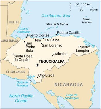
Location and Boundaries
Honduras, located at the widest part of the isthmus of Central America, is the second largest Central American republic. The triangular-shaped country has a total area of about 112,000 square kilometers. The 735-kilometer northern boundary is the Caribbean coast extending from the mouth of the Río Motagua on the west to the mouth of the Río Coco on the east, at Cabo Gracias a Dios. The 922-kilometer southeastern side of the triangle is the land border with Nicaragua; it follows the Río Coco near the Caribbean Sea and then extends southwestward through mountainous terrain to the Golfo de Fonseca on the Pacific Ocean. The southern apex of the triangle is a 153- kilometer coastline at the Golfo de Fonseca, which opens onto the Pacific Ocean. The western land boundary consists of the 342-kilometer border with El Salvador and the 256-kilometer border with Guatemala.
Honduras controls a number of islands as part of its offshore territories. In the Caribbean Sea, the islands of Roatán (Isla de Roatán), Utila, and Guanaja together form Islas de la Bahía (Bay Islands), one of the eighteen departments into which Honduras is divided. Roatán, the largest of the three islands, is fifty kilometers long by five kilometers wide. The Islas de la Bahía archipelago also has a number of smaller islands, among them the islets of Barbareta (Isla Barbareta), Santa Elena (Isla Santa Elena), and Morat (Isla Morat). Farther out in the Caribbean are the Islas Santanillas, formerly known as Swan Islands. A number of small islands and keys can be found nearby, among them Cayos Zapotillos and Cayos Cochinos. In the Golfo de Fonseca, the main islands under Honduran control are El Tigre, Zacate Grande (Isla Zacate Grande), and Exposición (Isla Exposición).
Boundary Disputes
A two-centuries-old border dispute between El Salvador and Honduras appears to have been resolved in 1993. At issue in this territorial dispute was ownership of six contested bolsones (pockets) of land encompassing a total area of 436.9 square kilometers as well as two islands (Meanguera and El Tigre) in the Golfo de Fonseca, and right of passage for Honduras to the Pacific Ocean from its southern coast.
The origins of the boundary dispute date back to the eighteenth century when colonial boundaries were ill defined. In the late nineteenth century, numerous attempts at mediation failed to settle the dispute. The issue continued to fester in the twentieth century and was a contributing factor in the outbreak of war between the two countries in 1969. The General Peace Treaty, signed by El Salvador and Honduras on October 30, 1980, in Lima, Peru, represented the first real breakthrough on this border dispute. The peace treaty stated that the two parties agreed to submit the boundary dispute to the International Court of Justice (ICJ) in The Hague if they failed to reach a border agreement after five years of negotiations. By 1985 the two countries had not reached an agreement. In 1986 the case reached the ICJ, which handed down a ruling on September 11, 1992. Both countries accepted the ICJ decision, and a commission was established to decide the citizenship of residents of the bolsones.
Of the 436.9 square kilometers in dispute, 300.6 square kilometers were granted to Honduras, and 136.3 were granted to El Salvador. Of the six bolsones, Honduras was awarded complete control of one and approximately 80 percent of another. The remaining four were split with El Salvador. El Salvador was awarded possession of the island of Meanguera, and Honduras was awarded control of the island of El Tigre. More importantly for Honduras, the ICJ ruling assured Honduras’s free passage to the Pacific Ocean. The ICJ also decided that the Golfo de Fonseca does not represent international waters because of the two countries’ shared history as provinces of the same colonial power and subsequent membership in the United Provinces of Central America. The court ruled, rather, that the Golfo de Fonseca is a condominium, with control being shared by El Salvador, Honduras, and Nicaragua. The latter country also has a coastline on the gulf. The decision allowed for the possibility that the three nations could divide the waters at a later date if they wished to do so.
Topography
Honduras has three distinct topographical regions: an extensive interior highland area and two narrow coastal lowlands. The interior, which constitutes approximately 80 percent of the country’s terrain, is mountainous. The larger Caribbean lowlands in the north and the Pacific lowlands bordering the Golfo de Fonseca are characterized by alluvial plains.
Interior Highlands
The interior highlands are the most prominent feature of Honduran topography. Composing approximately 80 percent of the country’s total area, these mountain areas are home to the majority of the population. Because the rugged terrain has made the land difficult to traverse and equally difficult to cultivate, this area has not been highly developed. The soil here is poor; Honduras lacks the rich volcanic ash found in other Central American countries. Until the early part of the twentieth century, the highlands economy consisted primarily of mining and livestock.
In the west, Honduras’s mountains blend into the mountain ranges of Guatemala. The western mountains have the highest peaks, with the Pico Congolón at an elevation of 2,500 meters and the Cerro de Las Minas at 2,850 meters. These mountains are woodland covered with mainly pine forests.
In the east, the mountains merge with those in Nicaragua. Although generally not as high as the mountains near the Guatemalan border, the eastern ranges possess some high peaks, such as the Montaña de la Flor at 2,300 meters, El Boquerón (Monte El Boquerón) at 2,485 meters, and Pico Bonito at 2,435 meters.
One of the most prominent features of the interior highlands is a depression that runs from the Caribbean Sea to the Golfo de Fonseca. This depression splits the country’s cordilleras into eastern and western parts and provides a relatively easy transportation route across the isthmus. Widest at its northern end near San Pedro Sula, the depression narrows as it follows the upper course of the Río Humuya. Passing first through Comayagua and then through narrow passes south of the city, the depression widens again as it runs along the border of El Salvador into the Golfo de Fonseca.
Scattered throughout the interior highlands are numerous flatfloored valleys, 300 to 900 meters in elevation, which vary in size. The floors of the large valleys provide sufficient grass, shrubs, and dry woodland to support livestock and, in some cases, commercial agriculture. Subsistence agriculture has been relegated to the slopes of the valleys, with the limitations of small-sized holdings, primitive technology, and low productivity that traditionally accompany hillside cultivation. Villages and towns, including the capital, Tegucigalpa, are tucked in the larger valleys.
Vegetation in the interior highlands is varied. Much of the western, southern, and central mountains are open woodland– supporting pine forest interspersed with some oak, scrub, and grassy clearings. The ranges toward the east are primarily continuous areas of dense, broad-leaf evergreen forest. Around the highest peaks, remnants of dense rain forest that formerly covered much of the area are still found.
The Caribbean Lowlands
This area of river valleys and coastal plains, which most Honduras call “the north coast,” or simply “the coast,” has traditionally been Honduras’s most exploited region. The central part of the Caribbean lowlands, east of La Ceiba, is a narrow coastal plain only a few kilometers wide. To the east and west of this section, however, the Caribbean lowlands widen and in places extend inland a considerable distance along broad river valleys. The broadest river valley, along the Río Ulúa near the Guatemalan border, is Honduras’s most developed area. Both Puerto Cortés, the country’s largest port, and San Pedro Sula, Honduras’s industrial capital, are located here.
To the east, near the Nicaraguan border, the Caribbean lowlands broaden to an extensive area known as the Mosquitia. Unlike the western part of the Caribbean lowlands, the Mosquitia is Honduras’s least-developed area. Underpopulated and culturally distinct from the rest of the country, the area consists of inland savannah with swamps and mangrove near the coast. During times of heavy rainfall, much of the savannah area is covered by shallow water, making transportation by means other than a shallow-draft boat almost impossible.
Pacific Lowlands
The smallest physiographic region of Honduras, the Pacific lowlands, is a strip of land averaging twenty-five kilometers wide on the north shore of the Golfo de Fonseca. The land is flat, becoming swampy near the shores of the gulf, and is composed mostly of alluvial soils washed down from the mountains. The gulf is shallow and the water rich in fish and mollusks. Mangroves along the shore make shrimp and shellfish particularly abundant by providing safe and abundant breeding areas amid their extensive networks of underwater roots.
Several islands in the gulf fall under Honduras’s jurisdiction. The two largest, Zacate Grande and El Tigre, are eroded volcanoes, part of the chain of volcanoes that extends along the Pacific coast of Central America. Both islands have volcanic cones more than 700 meters in elevation that serve as markers for vessels entering Honduras’s Pacific ports.
Climate
Although all of Honduras lies within the tropics, the climatic types of each of the three physiographic regions differ. The Caribbean lowlands have a tropical wet climate with consistently high temperatures and humidity, and rainfall fairly evenly distributed throughout the year. The Pacific lowlands have a tropical wet and dry climate with high temperatures but a distinct dry season from November through April. The interior highlands also have a distinct dry season, but, as is characteristic of a tropical highland climate, temperatures in this region decrease as elevation increases.
Unlike in more northerly latitudes, temperatures in the tropics vary primarily with elevation instead of with the season. Land below 1,000 meters is commonly known as tierra caliente (hot land), between 1,000 and 2,000 meters tierra templada (temperate land), and above 2,000 meters tierra fría (cold land). Both the Caribbean and Pacific lowlands are tierra caliente, with daytime highs averaging between 28° C and 32° C throughout the year. In the Pacific lowlands, April, the last month of the dry season, brings the warmest temperatures; the rainy season is slightly cooler, although higher humidity during the rainy season makes these months feel more uncomfortable. In the Caribbean lowlands, the only relief from the year-round heat and humidity comes during December or January when an occasional strong cold front from the north (a norte) brings several days of strong northwest winds and slightly cooler temperatures.
The interior highlands range from tierra templada to tierra fría. Tegucigalpa, in a sheltered valley and at an elevation of 1,000 meters, has a pleasant climate, with an average high temperature ranging from 30° C in April, the warmest month, to 25° C in January, the coolest. Above 2,000 meters, temperatures can fall to near freezing at night, and frost sometimes occurs.
Rain falls year round in the Caribbean lowlands but is seasonal throughout the rest of the country. Amounts are copious along the north coast, especially in the Mosquitia, where the average rainfall is 2,400 millimeters. Nearer San Pedro Sula, amounts are slightly less from November to April, but each month still has considerable precipitation. The interior highlands and Pacific lowlands have a dry season, known locally as “summer,” from November to April. Almost all the rain in these regions falls during the “winter,” from May to September. Total yearly amounts depend on surrounding topography; Tegucigalpa, in a sheltered valley, averages only 1,000 millimeters of precipitation.
Honduras lies within the hurricane belt, and the Caribbean coast is particularly vulnerable to hurricanes or tropical storms that travel inland from the Caribbean. Hurricane Francelia in 1969 and Tropical Storm Alleta in 1982 affected thousands of people and caused extensive damage to crops. Hurricane Fifi in 1974 was the worst natural disaster in recent Honduran history; more than 8,000 people were killed, and nearly the entire banana crop was destroyed. Hurricanes occasionally form over the Pacific and move north to affect southern Honduras, but Pacific storms are generally less severe and their landfall rarer.
Hydrography
Honduras is a water-rich country. The most important river in Honduras is the Ulúa, which flows 400 kilometers to the Caribbean through the economically important Valle de Sula. Numerous other rivers drain the interior highlands and empty north into the Caribbean. These other rivers are important, not as transportation routes, but because of the broad fertile valleys they have produced.
Rivers also define about half of Honduras’s international borders. The Río Goascorán, flowing to the Golfo de Fonseca, and the Río Lempa define part of the border between El Salvador and Honduras. The Río Coco marks about half of the border between Nicaragua and Honduras.
Despite an abundance of rivers, large bodies of water are rare. Lago de Yojoa, located in the west-central part of the country, is the sole natural lake in Honduras. This lake is twenty-two kilometers long and at its widest point measures fourteen kilometers. Several large, brackish lagoons open onto the Caribbean in northeast Honduras. These shallow bodies of water allow limited transportation to points along the coast.
People of Honduras
About 90% of the population is mestizo. There also are small minorities of European, African, Asian, Arab, and indigenous Indian descent. Most Hondurans are Roman Catholic, but Protestant churches are growing in number. Spanish is the predominant language, although some English is spoken along the northern coast and is prevalent on the Caribbean Bay Islands. Several indigenous Indian languages and Garifuna (a black Caribe/African language) also are spoken. The restored Mayan ruins near the Guatemalan border in Copan reflect the great Mayan culture that flourished there for hundreds of years until the early 9th century.
Population: 6,975,204 (July 2005 est.)
Age structure:
0-14 years: 42.22%
15-64 years: 54.21%
65 years and over: 3.57%
Population growth rate: 2.16%
Birth rate: 31.94 births/1,000 population
Death rate: 5.52 deaths/1,000 population
Net migration rate: -2.12 migrant(s)/1,000 population
Infant mortality rate: 30.88 deaths/1,000 live births
Life expectancy at birth:
total population: 69.35 years
male: 67.51 years
female: 71.28 years
Total fertility rate: 4.15 children born/woman
Nationality:
noun: Honduran(s)
adjective: Honduran
Ethnic groups: mestizo (mixed Amerindian and European) 90%, Amerindian 7%, black 2%, white 1%
Religions: Roman Catholic 97%, Protestant minority
Languages: Spanish, Amerindian dialects
Literacy:
definition: age 15 and over can read and write
total population: 72.7%
male: 72.6%
female: 72.7% (1995 est.)
History of Honduras
HONDURAS’S RUGGED TOPOGRAPHY and lack of natural resources explain much of its history and present-day underdevelopment. The land has been underpopulated since precolonial times; the great civilizations of Middle America lay to the north, and European immigrants to the area were few in number because the region lacked mineral wealth and land suitable for farming. Extensive mountain ranges kept Honduras from being considered as a site for a transisthmian canal in the nineteenth century. This “rejection,” however, brought the unexpected advantage of isolating the new nation from much of the international intrigue that engulfed Honduras’s neighbors. Lack of large areas of flat land for plantations also had an unanticipated result: Honduras never produced a powerful landholding oligarchy like those that controlled the economies and politics of many of the countries of Central America, and as a result it has a more egalitarian society with a less rigid class structure than its neighbors.
Honduras has frequently been exploited by outsiders. Neighbors in Central America took advantage of Honduras’s weakness and repeatedly intervened in Honduran internal affairs. Countries outside the region also manipulated Honduran politics from time to time to suit their own national interests. Intervention and manipulation were not limited to sovereign states. During the first half of the twentieth century, the Honduran economy was so dominated by the export of bananas that foreign banana companies often exercised as much power as the national government. Increased nationalism and economic diversification have strengthened national institutions in recent decades, but Honduras remains a nation highly sensitive to and dependent on external forces.
Although Honduras is the second largest country in Central America, it has little land available for cultivation. The terrain for the most part consists of rugged mountains, with narrow coastal plains to the north and south. Rainfall is abundant in the Caribbean lowlands and on some of the north-facing mountain slopes, but most of the arable valleys are fairly dry. When viewed from the air, most of the landscape appears barren. Unlike the more lush mountain areas of Guatemala and southern Mexico, the mountains and dry valleys of Honduras have always been rather inhospitable to settlers.
Honduras lay at the southern edge of the advanced civilizations of pre-Columbian Middle America. One of the most notable indigenous groups was the Maya, whose civilization spread south from the Yucatán and Guatemala in the fifth century A.D. In what is now northwestern Honduras, the Maya built the major ceremonial center of Copán. For three and a half centuries, the city was one of the principal centers of Mayan culture and trade. Sometime in the ninth century A.D., Copán, as well as most other Mayan cities, was abandoned. The reason for this abrupt event continues to puzzle archaeologists. Theories of civil war, disease, drought, overpopulation, and crop failure have all been proposed. Whatever the cause, the fall of the Mayan civilization apparently affected only the city dwellers. Although the priests and rulers who built the temples, inscribed the glyphs, and developed the astronomy and mathematics suddenly vanished, the peasants remained in the area and form a continuum of language and culture that exist to this day. European contact with Honduras began with Christopher Columbus in 1502, but little exploration or settlement by Europeans took place for the next two decades. Spanish conquistadors and a few settlers began arriving in the 1520s, but the area soon became a battleground for competing colonial authorities. The population of the area dropped precipitously as the indigenous population was nearly wiped out by new diseases, mistreatment, and exportation of large numbers of persons to other colonies as slave labor. By 1539 only an estimated 15,000 native people remained under Spanish control; two years later this figure had declined to 8,000. Most of the indigenous inhabitants were organized into encomiendas, a system that left the native people as vassals in their villages under the control of individual Spanish settlers.
The colony began to grow in the 1540s as a variety of agricultural activities developed and limited gold and silver mining began. However, gold production declined in the 1560s, the silver boom peaked in 1584, and economic depression returned shortly thereafter. By the seventeenth century, Honduras had become a poor and neglected backwater of the Spanish colonial empire, having a scattered population of mestizos (of mixed European and native ancestry), native people, blacks, and a handful of Spanish administrators and landowners. Cattle raising was the only important economic activity, and much of the Honduran interior and Caribbean coast remained uncolonized and outside effective Spanish control.
The eighteenth century saw slow growth of the colony as agriculture diversified and grew and the central government increased its political control over the area. Conflict over trade policy, however, sparked a rivalry between Honduras’s principal cities, León and Granada, a rivalry that eventually became a blood feud lasting for almost 200 years. In Spain, the Bourbons assumed the throne in the early years of the century, and the revitalized Spanish government made several efforts to wrest control of the Caribbean coast from the British.
In the early nineteenth century, Spanish power went into rapid decline. The Napoleonic wars created turmoil in Spain, and the Spanish colonies took advantage of this diversion of attention and resources in the motherland to establish themselves as sovereign nations.
Independence
Honduras, along with the other Central American provinces, gained independence from Spain in 1821; the country then briefly was annexed to the Mexican Empire. In 1823, Honduras joined the newly formed United Provinces of Central America. Social and economic differences between Honduras and its regional neighbors exacerbated harsh partisan strife among Central American leaders and brought on the federation’s collapse in 1838. Gen. Francisco Morazan–a Honduran national hero–led unsuccessful efforts to maintain the federation, and restoring Central American unity remained the chief aim of Honduran foreign policy until after World War I.
Since independence, Honduras has been plagued with nearly 300 internal rebellions, civil wars, and changes of government–more than half occuring during the 20th century. The country traditionally lacked both an economic infrastructure and social and political integration. Its agriculturally based economy came to be dominated in the 1900s by U.S. companies that established vast banana plantations along the north coast. Foreign capital, plantation life, and conservative politics held sway in Honduras from the late 19th until the mid-20th century. During the relatively stable years of the Great Depression, authoritarian Gen. Tiburcio Carias Andino controlled Honduras. His ties to dictators in neighboring countries and to U.S. banana companies helped him maintain power until 1948. By then, provincial military leaders had begun to gain control of the two major parties, the Nationalists and the Liberals.
From Military to Civilian Rule
In October 1955–after two authoritarian administrations and a general strike by banana workers on the north coast in 1954–young military reformists staged a palace coup that installed a provisional junta and paved the way for constituent assembly elections in 1957. This assembly appointed Dr. Ramon Villeda Morales as president and transformed itself into a national legislature with a 6-year term. The Liberal Party ruled during 1957-63. At the same time, the military took its first steps to become a professional institution independent of leadership from any one political party, and the newly created military academy graduated its first class in 1960. In October 1963, conservative military officers preempted constitutional elections and deposed Villeda in a bloody coup. These officers exiled Liberal Party members and took control of the national police. The armed forces, led by Gen. Lopez Arellano, governed until 1970. Popular discontent continued to rise after a 1969 border war with El Salvador. A civilian president–Ramon Cruz of the National Party–took power briefly in 1970 but proved unable to manage the government. In December 1972, Gen. Lopez staged another coup. Lopez adopted more progressive policies, including land reform, but his regime was brought down in the mid-1970s by corruption scandals.
Gen. Lopez’ successors continued armed forces modernization programs, building army and security forces, and concentrating on Honduran air force superiority over its neighbors. The regimes of Gen. Melgar Castro (1975-78) and Gen. Paz Garcia (1978-83) largely built the current physical infrastructure and telecommunications system of Honduras. The country also enjoyed its most rapid economic growth during this period, due to greater international demand for its products and the availability of foreign commercial lending.
Following the overthrow of Anastasio Somoza in Nicaragua in 1979 and general instability in El Salvador at the time, the Honduran military accelerated plans to return the country to civilian rule. A constituent assembly was popularly elected in April 1980 and general elections were held in November 1981. A new constitution was approved in 1982, and the Liberal Party government of President Roberto Suazo Cordoba took office following free and fair elections power.
Suazo relied on U.S. support to help with a severe economic recession and with the threat posed by the revolutionary Sandinista government in Nicaragua amid a brutal civil war in El Salvador. Close cooperation on political and military issues with the United States was complemented by ambitious social and economic development projects sponsored by the U.S. Agency for International Development (USAID). Honduras became host to the largest Peace Corps mission in the world, and nongovernmental and international voluntary agencies proliferated.
As the November 1985 election approached, the Liberal Party had difficulty settling on a candidate, and interpreted election law as permitting multiple presidential candidates from one party. The Liberal Party claimed victory when its presidential candidates, who received 42% of the vote, collectively outpolled the National Party candidate, Rafael Leonardo Callejas. Jose Azcona Hoyo, the candidate receiving the most votes among the Liberals, assumed the presidency in January 1986. With the endorsement of the Honduran military, the Azcona administration ushered in the first peaceful transfer of power between civilian presidents in more than 30 years. Four years later, Rafael Callejas won the presidential election, taking office in January 1990. Callejas concentrated on economic reform, reducing the deficit, and taking steps to deal with an overvalued exchange rate and major structural barriers to investment. He began the movement to place the military under civilian control and laid the groundwork for the creation of the public ministry (Attorney General’s office).
Despite his administration’s economic reforms, the nation’s fiscal deficit ballooned during Callejas’ last year in office. Growing public dissatisfaction with the rising cost of living and with widespread government corruption led voters in 1993 to elect Liberal Party candidate Carlos Roberto Reina over National Party contender Oswaldo Ramos Soto, with Reina winning 56% of the vote.
President Reina, elected on a platform calling for a “moral revolution,” actively prosecuted corruption and pursued those responsible for human rights abuses in the 1980s. He created a modern attorney general’s office and an investigative police force and was successful in increasing civilian control over the armed forces and transferring the police from military to civilian authority.
Reina also restored national fiscal health by substantially increasing Central Bank net international reserves, reducing inflation, restoring economic growth, and, perhaps most importantly, holding down spending.
Carlos Roberto Flores Facusse took office on January 27, 1998, as Honduras’ fifth democratically elected president since democratic institutions were restored in 1981. Like three of his four predecessors, Flores was a member of the Liberal Party. He was elected by a 10% margin over his main opponent, National Party nominee Nora de Melgar. Upon taking office on January 27, 1998, Flores inaugurated programs of reform and modernization of the Honduran Government and economy, with emphasis on helping Honduras’ poorest citizens while maintaining the country’s fiscal health and improving international competitiveness.
In October 1998, Hurricane Mitch devastated Honduras, leaving more than 5,000 people dead and 1.5 million displaced. Damages totaled nearly $3 billion. The Honduran Government agreed to a new transparent process to manage relief funds, which included significant donor oversight. This open process greatly facilitated the relief and reconstruction effort. President Flores and his administration have successfully managed more than $600 million in international assistance. Civil society’s role in the government-coordinated reconstruction process has been lauded internationally. President Flores also forwarded judicial and penal reforms. He established an anticorruption commission, supported passage of a new penal code based on the oral accusatorial system, and saw passage of a law that creates an independent Supreme Court. Flores cemented the transition from military to civilian rule by eliminating the commander in chief position, and by signing a law that establishes civilian control formally over the military.
Ricardo Maduro Joest of the National Party was elected to the Honduran presidency on November 25, 2001, outpolling the Liberal candidate, Rafael Pineda Ponce, by 8%. He will be inaugurated on January 27, 2002. The elections, characterized by international observer teams as free, fair, and peaceful, reflected the maturing of Honduras’ democratic institutions. During his campaign, President-elect Maduro promised to reduce crime, reinvigorate the economy, and fight corruption.
Honduras Economy
Honduras is one of the poorest and least developed countries in Latin America. The economy is based mostly on agriculture, which accounted for 15% of GDP in 1999. Coffee accounted for 26% ($340 million) of total Honduran export revenues in 2000. However, plummeting world coffee prices in 2001 caused coffee export revenues to fall by 50% during the year. Bananas, formerly the country’s second-largest export until being virtually wiped out by 1998’s Hurricane Mitch, recovered in 2000 to 57% of pre-Mitch levels. The banana sector continued to recover in 2001 and is estimated to generate some $210 million in export revenues, equal to pre-Mitch levels. Cultivated shrimp are another important export generating $125 million in 2001. Honduras has extensive forest, marine, and mineral resources, although widespread slash-and-burn agricultural methods continue to destroy Honduran forests. Remittances from Hondurans living abroad (mostly in the United States–rose 28% to $410 million in 2000 and were expected to rise in 2001 to $450-$500 million. The currency (lempira) has only moderately devalued in nominal terms over the past year.
Unemployment is estimated at around 4.0%, though underemployment is much higher. The Honduran economy grew 4.7% in 2000, recovering from the Mitch-induced recession (-1.9%) of 1999. The economy is expected to grow 3% in 2001, led by continuation of foreign-funded reconstruction projects. The Honduran maquiladora sector, the second-largest in the world, continued its strong performance in 2000, providing employment to more than 125,000 workers and generating over $528 million in foreign exchange for the country. The economic slowdown in the U.S. caused Honduras’ maquila sector growth to stagnate in 2001 and employment in the sector to drop to about 115,000.
Inflation, as measured by the consumer price index, was 10.1% in 2000, down slightly from the 10.9% recorded in 1999. The country’s international reserve position continued to be strong in 2000, at slightly over $1 billion.
The country signed an Enhanced Structural Adjustment Facility (ESAF)–later converted to a Poverty Reduction and Growth Facility (PRGF) with the International Monetary Fund (IMF) in March 1999. While Honduras continues to maintain stable macroeconomic policies, it has lagged in implementing structural reforms, such as privatization of the publicly owned telephone and energy distribution companies. Honduras received significant debt relief in the aftermath of Hurricane Mitch, including the suspension of bilateral debt-service payments and bilateral debt reduction by the Paris Club–including the U.S.–worth more than $400 million. In July 2000, Honduras reached its decision point under the Highly Indebted Poor Countries Initiative (HIPC), qualifying the country for interim multilateral debt relief. In 2001, the IMF approved Honduras’ third year PRGF, and together with the World Bank, the Poverty Reduction Strategy Paper, which makes Honduras eligible for interim debt relief and qualify for $556 million in debt relief in present value terms at its completion point in December 2002.
GDP: purchasing power parity – $17 billion (2000 est.)
GDP – real growth rate: 4.7% (2000 est.)
GDP – per capita: purchasing power parity – $2,700 (2000 est.)
GDP – composition by sector:
agriculture: 16.2%
industry: 31.9%
services: 51.9% (1999 est.)
Household income or consumption by percentage share:
lowest 10%: 1.2%
highest 10%: 42.1% (1996)
Inflation rate (consumer prices): 10.1% (2000 est.)
Labor force: 2.3 million (1997 est.)
Labor force – by occupation: agriculture 29%, industry 21%, services 60% (1998 est.)
Unemployment rate: 28% including underemployment (2000 est.)
Budget:
revenues: $607 million
expenditures: $411.9 million, including capital expenditures of $106 million (1999 est.)
Industries: sugar, coffee, textiles, clothing, wood products
Industrial production growth rate: 4% (1999 est.)
Electricity – production: 3.319 billion kWh (1999)
Electricity – production by source:
fossil fuel: 44.71%
hydro: 55.29%
nuclear: 0%
other: 0% (1999)
Agriculture – products: bananas, coffee, citrus; beef; timber; shrimp
Exports: $2 billion (f.o.b., 2000 est.)
Exports – commodities: coffee, bananas, shrimp, lobster, meat; zinc, lumber
Exports – partners: United States 35.4%, Germany 7.5%, El Salvador 6.4%, Guatemala 5.8%, Nicaragua 4.8% (1999)
Imports: $2.8 billion (f.o.b., 2000 est.)
Imports – commodities: machinery and transport equipment, industrial raw materials, chemical products, fuels, foodstuffs
Imports – partners: United States 47.1%, Guatemala 7.4%, El Salvador 5.9%, Mexico 4.8%, Japan 4.7% (1999)
Debt – external: $5.4 billion (2000)
Economic aid – recipient: $557.8 million (1999)
Currency: lempira (HNL)
Map of Honduras