Background: The Gilbert Islands were granted self-rule by the UK in 1971 and complete independence in 1979 under the new name of Kiribati (pronounced “keer-ih-bahs”). The US relinquished all claims to the sparsely inhabited Phoenix and Line Island groups in a 1979 treaty of friendship with Kiribati.
Government type: republic
Capital: Tarawa
Currency: 1 Australian dollar ($A) = 100 cents
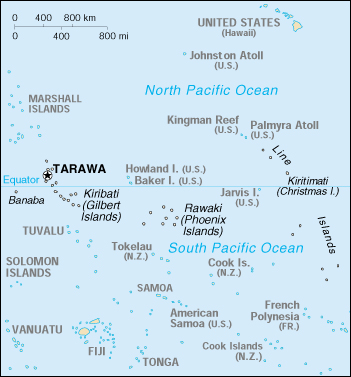
Geography of Kiribati
Location: Oceania, group of islands in the Pacific Ocean, straddling the equator, about one-half of the way from Hawaii to Australia; note – on 1 January 1995, Kiribati unilaterally moved the International Date Line from the middle of the country to include its easternmost islands and make it the same day throughout the country.
Geographic coordinates: 1 25 N, 173 00 E
Area:
total: 717 sq km
land: 717 sq km
water: 0 sq km
note: includes three island groups – Gilbert Islands, Line Islands, Phoenix Islands
Land boundaries: 0 km
Coastline: 1,143 km
Maritime claims:
exclusive economic zone: 200 nm
territorial sea: 12 nm
Climate: tropical; marine, hot and humid, moderated by trade winds
Terrain: mostly low-lying coral atolls surrounded by extensive reefs
Elevation extremes:
lowest point: Pacific Ocean 0 m
highest point: unnamed location on Banaba 81 m
Most of the land is less than two meters above sea level. A 1989 United Nations report identified Kiribati as one of the countries that would completely disappear in the 21st century if steps were not taken to address global climate change. In mid-1999 it was announced that two uninhabited coral reefs had sunk beneath the sea.
Natural resources: phosphate (production discontinued in 1979)
Land use:
arable land: 0%
permanent crops: 51%
permanent pastures: 0%
forests and woodland: 3%
other: 46% (1993 est.)
Natural hazards: typhoons can occur any time, but usually November to March; occasional tornadoes; low-level of some of the islands make them very sensitive to sea-level rise
Environment – current issues: heavy pollution in lagoon of south Tarawa atoll due to heavy migration mixed with traditional practices such as lagoon latrines and open-pit dumping; ground water at risk
Environment – international agreements:
party to: Biodiversity, Climate Change, Climate Change-Kyoto Protocol, Desertification, Hazardous Wastes, Marine Dumping, Ozone Layer Protection
signed, but not ratified: none of the selected agreements
Geography – note: 20 of the 33 islands are inhabited; Banaba (Ocean Island) in Kiribati is one of the three great phosphate rock islands in the Pacific Ocean – the others are Makatea in French Polynesia, and Nauru.
People of Kiribati
Population: 103,092 (July 2005 est.)
Age structure:
0-14 years: 40.53%
15-64 years: 56.27%
65 years and over: 3.2%
Population growth rate: 2.31%
Owing to the population growth rate and the overcrowding around the capital, a program of migration was begun in 1989 to move nearly 5,000 inhabitants to outlying atolls, mainly in the Line Islands. A further program of resettlement to the Phoenix Islands was begun in 1995.
Birth rate: 31.98 births/1,000 population
Death rate: 8.88 deaths/1,000 population
Net migration rate: 0 migrant(s)/1,000 population
Infant mortality rate: 54 deaths/1,000 live births
Life expectancy at birth:
total population: 60.16 years
male: 57.25 years
female: 63.22 years
Total fertility rate: 4.36 children born/woman
Nationality:
noun: I-Kiribati (singular and plural)
adjective: I-Kiribati
Ethnic groups: Micronesian
Religions: Roman Catholic 54%, Protestant (Congregational) 30%, some Seventh-Day Adventist, Baha’i, Latter-day Saints, and Church of God (1996)
Languages: English (official), Gilbertese
History of Kiribati
The I-Kiribati people settled what would become known as the Gilbert Islands between 1000 and 1300 AD. Subsequent invasions by Fijians and Tongans introduced Polynesian elements to the Micronesian culture, but extensive intermarriage produced a population reasonably homogeneous in appearance and traditions.
European contact began in the 16th century. Whalers, slave traders, and merchant vessels arrived in great numbers in the 1800s, and the resulting upheaval fomented local tribal conflicts and introduced damaging European diseases. In an effort to restore a measure of order, the Gilbert and Ellice Islands (now Tuvalu) consented to becoming British protectorates in 1892. Banaba (Ocean Island) was annexed in 1900 after the discovery of phosphate-rich guano deposits, and the entire collection was made a British colony in 1916. The Line and Phoenix Islands were incorporated piecemeal over the next 20 years.
Japan seized the islands during World War II to form part of their island defenses. In November 1943, allied forces threw themselves against Japanese positions at Tarawa Atoll in the Gilberts, resulting in some of the bloodiest fighting of the Pacific campaign. The battle was a major turning point in the war for the Allies.
Britain began expanding self-government in the islands during the 1960s. In 1975 the Ellice Islands separated from the colony to form the independent state of Tuvalu. The Gilberts obtained internal self-government in 1977, and formally became an independent nation on July 12, 1979 under the name of Kiribati.
Post-independence politics were initially dominated by Ieremia Tabai, Kiribati’s first president, who served from 1979 to 1991. Teburoro Tito has been President since 1994, and was most recently reelected in 1998.
Kiribati Economy
Economy – overview: A remote country of 33 scattered coral atolls, Kiribati has few national resources. Commercially viable phosphate deposits were exhausted at the time of independence from the United Kingdom in 1979. Copra and fish now represent the bulk of production and exports. The economy has fluctuated widely in recent years. Economic development is constrained by a shortage of skilled workers, weak infrastructure, and remoteness from international markets. Tourism provides more than one-fifth of GDP. The financial sector is at an early stage of development as is the expansion of private sector initiatives. Foreign financial aid, largely from the UK and Japan, is a critical supplement to GDP, equal to 25%-50% of GDP in recent years. Remittances from workers abroad account for more than $5 million each year. Performance in 2000 fell short of the 2.5% growth in 1999, which benefited from increased copra production and exceptionally large revenues from fishing licenses.
GDP: purchasing power parity – $76 million (2000 est.), supplemented by a nearly equal amount from external sources
GDP – real growth rate: 1% (2000 est.)
GDP – per capita: purchasing power parity – $850 (2000 est.)
GDP – composition by sector:
agriculture: 14%
industry: 7%
services: 79% (1996 est.)
Inflation rate (consumer prices): 2% (1999 est.)
Labor force: 7,870 economically active, not including subsistence farmers (1985 est.)
Unemployment rate: 2%; underemployment 70% (1992 est.)
Budget:
revenues: $33.3 million
expenditures: $47.7 million (1996 est.)
Industries: fishing, handicrafts
Industrial production growth rate: 0.7% (1992 est.)
Electricity – production: 7 million kWh (1999)
Electricity – production by source:
fossil fuel: 100%
hydro: 0%
nuclear: 0%
other: 0% (1999)
Agriculture – products: copra, taro, breadfruit, sweet potatoes, vegetables; fish
Exports: $6 million (f.o.b., 1998)
Exports – commodities: copra 62%, seaweed, fish
Exports – partners: Bangladesh, Australia, US, Hong Kong (1999)
Imports: $44 million (c.i.f., 1999)
Imports – commodities: foodstuffs, machinery and equipment, miscellaneous manufactured goods, fuel
Imports – partners: Australia, Fiji, Japan, NZ, China (1999)
Debt – external: $10 million (1999 est.)
Economic aid – recipient: $15.5 million (1995), largely from UK and Japan
Currency: Australian dollar (AUD)
Map of Kiribati