Background: Mayotte was ceded to France along with the other Comoros in 1843. It was the only island in the archipelago that voted in 1974 to retain its link with France and forgo independence.
Dependency status: territorial collectivity of France
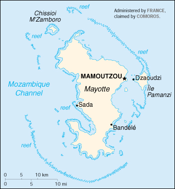
Capital: Mamoutzou
Currency: 1 French franc (F) = 100 centimes
Geography of Mayotte
Location: Southern Africa, island in the Mozambique Channel, about one-half of the way from northern Madagascar to northern Mozambique
Geographic coordinates: 12 50 S, 45 10 E
Area:
total: 374 sq km
land: 374 sq km
water: 0 sq km
Land boundaries: 0 km
Coastline: 185.2 km
Maritime claims:
exclusive economic zone: 200 nm
territorial sea: 12 nm
Climate: tropical; marine; hot, humid, rainy season during northeastern monsoon (November to May); dry season is cooler (May to November)
Terrain: generally undulating, with deep ravines and ancient volcanic peaks
Elevation extremes:
lowest point: Indian Ocean 0 m
highest point: Benara 660 m
Natural resources: NEGL
Natural hazards: cyclones during rainy season
Geography – note: part of Comoro Archipelago; 18 islands
People of Mayotte
Population: 193,633 (July 2005 est.)
Age structure:
0-14 years: 46.59%
15-64 years: 51.73%
65 years and over: 1.68%
Population growth rate: 4.58%
Birth rate: 44.39 births/1,000 population
Death rate: 8.84 deaths/1,000 population
Net migration rate: 10.28 migrant(s)/1,000 population
Infant mortality rate: 69.54 deaths/1,000 live births
Life expectancy at birth:
total population: 59.83 years
male: 57.77 years
female: 61.96 years
Total fertility rate: 6.24 children born/woman
Nationality:
noun: Mahorais (singular and plural)
adjective: Mahoran
Religions: Muslim 97%, Christian (mostly Roman Catholic)
Languages: Mahorian (a Swahili dialect), French (official language) spoken by 35% of the population
Mayotte Economy
Economy – overview: Economic activity is based primarily on the agricultural sector, including fishing and livestock raising. Mayotte is not self-sufficient and must import a large portion of its food requirements, mainly from France. The economy and future development of the island are heavily dependent on French financial assistance, an important supplement to GDP. Mayotte’s remote location is an obstacle to the development of tourism.
GDP: purchasing power parity – $85 million (1998 est.)
GDP – per capita: purchasing power parity – $600 (1998 est.)
Unemployment rate: 45% (1997)
Budget:
expenditures: $73 million (1991 est.)
Industries: newly created lobster and shrimp industry, construction
Agriculture – products: vanilla, ylang-ylang (perfume essence), coffee, copra
Exports: $3.44 million (f.o.b., 1997)
Exports – commodities: ylang-ylang (perfume essence), vanilla, copra, coconuts, coffee, cinnamon
Exports – partners: France 80%, Comoros 15%, Reunion
Imports: $141.3 million (f.o.b., 1997)
Imports – commodities: food, machinery and equipment, transportation equipment, metals, chemicals
Imports – partners: France 66%, Africa 14%, Southeast Asia 11% (1997)
Economic aid – recipient: $107.7 million (1995); note – extensive French financial assistance
Currency: euro (EUR)
Map of Mayotte