Facts About Senegal
Background: Independent from France in 1960, Senegal joined with The Gambia to form the nominal confederation of Senegambia in 1982. However, the envisaged integration of the two countries was never carried out, and the union was dissolved in 1989. Despite peace talks, a southern separatist group sporadically has clashed with government forces since 1982. Senegal has a long history of participating in international peacekeeping.
Government type: republic under multiparty democratic rule
Capital: Dakar
Currency: 1 Communaute Financiere Africaine franc (XOF) = 100 centimes
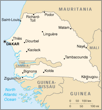
Geography of Senegal
Location: Western Africa, bordering the North Atlantic Ocean, between Guinea-Bissau and Mauritania
Geographic coordinates: 14 00 N, 14 00 W
Area:
total: 196,190 sq km
land: 192,000 sq km
water: 4,190 sq km
Land boundaries:
total: 2,640 km
border countries: The Gambia 740 km, Guinea 330 km, Guinea-Bissau 338 km, Mali 419 km, Mauritania 813 km
Coastline: 531 km
Maritime claims:
contiguous zone: 24 nm
continental shelf: 200 nm or to the edge of the continental margin
exclusive economic zone: 200 nm
territorial sea: 12 nm
Climate: tropical; hot, humid; rainy season (May to November) has strong southeast winds; dry season (December to April) dominated by hot, dry, harmattan wind
Terrain: generally low, rolling, plains rising to foothills in southeast
Elevation extremes:
lowest point: Atlantic Ocean 0 m
highest point: unnamed feature near Nepen Diakha 581 m
Natural resources: fish, phosphates, iron ore
Land use:
arable land: 12%
permanent crops: 0%
permanent pastures: 16%
forests and woodland: 54%
other: 18% (1993 est.)
Irrigated land: 710 sq km (1993 est.)
Natural hazards: lowlands seasonally flooded; periodic droughts
Environment – current issues: wildlife populations threatened by poaching; deforestation; overgrazing; soil erosion; desertification; overfishing.
Environment – international agreements:
party to: Biodiversity, Climate Change, Desertification, Endangered Species, Hazardous Wastes, Law of the Sea, Marine Life Conservation, Nuclear Test Ban, Ozone Layer Protection, Ship Pollution, Wetlands, Whaling
signed, but not ratified: Marine Dumping
Geography – note: westernmost country on the African continent; The Gambia is almost an enclave of Senegal.
People of Senegal
About 70% of Senegal’s population is rural. In rural areas, density varies from about 77 per square kilometer (200 per sq. mi.) in the west-central region to 2 per square kilometer (5 per sq. mi.) in the arid eastern section. About 50,000 Europeans (mostly French) and Lebanese reside in Senegal, mainly in the cities. French is the official language but is used regularly only by the literate minority. All Senegalese speak an indigenous language, of which Wolof has the largest usage.
Population: 11,126,832 (July 2005 est.)
Age structure:
0-14 years: 44.07%
15-64 years: 52.88%
65 years and over: 3.05%
Population growth rate: 2.93%
Birth rate: 37.46 births/1,000 population
Death rate: 8.35 deaths/1,000 population
Net migration rate: 0.21 migrant(s)/1,000 population
Infant mortality rate: 56.75 deaths/1,000 live births
Life expectancy at birth:
total population: 62.56 years
male: 60.94 years
female: 64.22 years
Total fertility rate: 5.12 children born/woman
Nationality:
noun: Senegalese (singular and plural)
adjective: Senegalese
Ethnic groups: Wolof 43.3%, Pular 23.8%, Serer 14.7%, Jola 3.7%, Mandinka 3%, Soninke 1.1%, European and Lebanese 1%, other 9.4%
Religions: Muslim 92%, indigenous beliefs 6%, Christian 2% (mostly Roman Catholic)
Languages: French (official), Wolof, Pulaar, Jola, Mandinka
Literacy:
definition: age 15 and over can read and write
total population: 33.1%
male: 43%
female: 23.2% (1995 est.)
History of Senegal
Archaeological findings throughout the area indicate that Senegal was inhabited in prehistoric times. Islam established itself in the Senegal River valley in the 11th century; 95% of Senegalese today are Muslims. In the 13th and 14th centuries, the area came under the influence of the Mandingo empires to the east; the Jolof Empire of Senegal also was founded during this time.
In January 1959, Senegal and the French Soudan merged to form the Mali Federation, which became fully independent on June 20, 1960, as a result of the independence and the transfer of power agreement signed with France on April 4, 1960. Due to internal political difficulties, the Federation broke up on August 20, 1960. Senegal and Soudan (renamed the Republic of Mali) proclaimed independence. Leopold Sedar Senghor, internationally known poet, politician, and statesman, was elected Senegal’s first president in August 1960.
After the breakup of the Mali Federation, President Senghor and Prime Minister Mamadou Dia governed together under a parliamentary system. In December 1962, their political rivalry led to an attempted coup by Prime Minister Dia. Although this was put down without bloodshed, Dia was arrested and imprisoned, and Senegal adopted a new constitution that consolidated the President’s power. In 1980, President Senghor decided to retire from politics, and he handed power over in 1981 to his handpicked successor, Abdou Diouf.
Abdou Diouf was president from 1981-2000. He encouraged broader political participation, reduced government involvement in the economy, and widened Senegal’s diplomatic engagements, particularly with other developing nations. Domestic politics on occasion spilled over into street violence, border tensions, and a violent separatist movement in the southern region of the Casamance. Nevertheless, Senegal’s commitment to democracy and human rights strengthened. Diouf served four terms as President. In the presidential election of 2000, he was defeated, in a free and fair election, by opposition leader Abdoulaye Wade. Senegal experienced its second peaceful transition of power, and its first from one political party to another.
Senegal Economy
The former capital of French West Africa, Senegal is a semi-arid country located on the westernmost point of Africa. Predominantly rural and with limited natural resources, the country earns foreign exchange from fish, phosphates, peanuts, tourism, and services. Its economy is highly vulnerable to variations in rainfall and changes in world commodity prices. Senegal depends heavily on foreign assistance, which in 2000 represented about 32% of overall government spending–including both current expenditures and capital investments–or CFA 270.8 billion (U.S.$ 361.0 million).
Since the January 1994 CFA franc devaluation, the International Monetary Fund (IMF), the World Bank, and other multilateral and bilateral creditors have been supporting the Government of Senegal’s structural and sectoral adjustment programs. The broad objectives of the program have been to facilitate growth and development by reducing the role of government in the economy, improving public sector management, enhancing incentives for the private sector, and reducing poverty.
With an external debt of $ 2,495 million, and with its economic reform program on track, Senegal qualified for the multilateral debt relief initiative for heavily indebted poor countries (HIPC). Progress on structural reforms is on track, but the pace of reforms remains slow, as delays occur in implementing a number of measures on the privatization program, good governance issues, and the promotion of private sector activity. However, macroeconomic indicators show that Senegal turned in a respectable performance in meeting IMF targets in 2000: annual GDP growth increased to 5.7%, compared to 5.1% in 1999. Inflation was reported to be 0.7% compared to 0.8% in 1999, and the current account deficit (excluding transfers) was held at less than 6% of GDP.
The fishing sector has replaced the groundnut sector as Senegal’s export leader. Its export earnings reached $239 million in 2000. The industrial fishing operations struggle with high costs, and Senegalese tuna is rapidly losing the French market to more efficient Asian competitors.
Phosphate production, the second major foreign exchange earner, has been steady at about $95 million. Exports of peanut products reached $79 million in 2000 and represented 11% of total export earnings. Receipts from tourism, the fourth major foreign exchange earner, have picked up since the January 1994 devaluation. In 2000, some 500,000 tourists visited Senegal, earning the country $120 million.
Senegal’s new Agency for the Promotion of Investment (APIX) plays a pivotal role in the government’s foreign investment program. Its objective is to increase the investment rate from its current level of 20.6% to 30%. Currently, there are no restrictions on the transfer or repatriation of capital and income earned, or investment financed with convertible foreign exchange. Direct U.S. investment in Senegal remains about $38 million, mainly in petroleum marketing, pharmaceuticals manufacturing, chemicals, and banking. Economic assistance, about $350 million a year, comes largely from France, the IMF, the World Bank, and the United States. Canada, Italy, Japan, and Germany also provide assistance.
Senegal has well-developed though costly port facilities, a major international airport serving 23 international airlines, and direct and expanding telecommunications links with major world centers.
GDP: purchasing power parity – $16 billion (2000 est.)
GDP – real growth rate: 5.7% (2000 est.)
GDP – per capita: purchasing power parity – $1,600 (2000 est.)
GDP – composition by sector:
agriculture: 19%
industry: 20%
services: 61% (1997 est.)
Household income or consumption by percentage share:
lowest 10%: 1.4%
highest 10%: 42.8% (1991)
Inflation rate (consumer prices): 1.5% (2000 est.)
Labor force – by occupation: agriculture 60%
Unemployment rate: urban youth 40%
Budget:
revenues: $885 million
expenditures: $885 million, including capital expenditures of $125 million (1996 est.)
Industries: agricultural and fish processing, phosphate mining, fertilizer production, petroleum refining, construction materials
Industrial production growth rate: 7% (1998 est.)
Electricity – production: 1.27 billion kWh (1999)
Electricity – production by source:
fossil fuel: 100%
hydro: 0%
nuclear: 0%
other: 0% (1999)
Electricity – consumption: 1.181 billion kWh (1999)
Agriculture – products: peanuts, millet, corn, sorghum, rice, cotton, tomatoes, green vegetables; cattle, poultry, pigs; fish
Exports: $959 million (f.o.b., 2000)
Exports – commodities: fish, ground nuts (peanuts), petroleum products, phosphates, cotton
Exports – partners: France 17%, India 17%, Italy 12%, Spain 6%, Mali 6%, Cote d’Ivoire 4% (1999)
Imports: $1.3 billion (f.o.b., 2000)
Imports – commodities: foods and beverages, consumer goods, capital goods, petroleum products
Imports – partners: France 30%, Nigeria 7%, Italy 6%, Thailand 5%, Germany 4%, US 4% (1999)
Debt – external: $4.1 billion (1998 est.)
Economic aid – recipient: $647.5 million (1995)
Currency: Communaute Financiere Africaine franc (XOF); note – responsible authority is the Central Bank of the West African States
Map of Senegal