Facts About Suriname
Background: Independence from the Netherlands was granted in 1975. Five years later the civilian government was replaced by a military regime that soon declared a socialist republic. It continued to rule through a succession of nominally civilian administrations until 1987, when international pressure finally brought about a democratic election. In 1989, the military overthrew the civilian government, but a democratically elected government returned to power in 1991.
Government type: constitutional democracy
Capital: Paramaribo
Currency: 1 Surinamese guilder (SRG) = 100 cents
Geography of Suriname
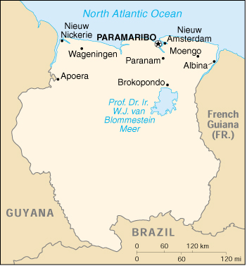
Location: Northern South America, bordering the North Atlantic Ocean, between French Guiana and Guyana
Geographic coordinates: 4 00 N, 56 00 W
Area:
total: 163,270 sq km
land: 161,470 sq km
water: 1,800 sq km
Land boundaries:
total: 1,707 km
border countries: Brazil 597 km, French Guiana 510 km, Guyana 600 km
Coastline: 386 km
Maritime claims:
exclusive economic zone: 200 nm
territorial sea: 12 nm
Climate: tropical; moderated by trade winds
Terrain: mostly rolling hills; narrow coastal plain with swamps
Elevation extremes:
lowest point: unnamed location in the coastal plain -2 m
highest point: Wilhelmina Gebergte 1,286 m
Natural resources: timber, hydropower, fish, kaolin, shrimp, bauxite, gold, and small amounts of nickel, copper, platinum, iron ore
Land use:
arable land: 0%
permanent crops: 0%
permanent pastures: 0%
forests and woodland: 96%
other: 4% (1993 est.)
Irrigated land: 600 sq km (1993 est.)
Environment – current issues: deforestation as timber is cut for export; pollution of inland waterways by small-scale mining activities
Environment – international agreements:
party to: Biodiversity, Climate Change, Endangered Species, Law of the Sea, Marine Dumping, Nuclear Test Ban, Ozone Layer Protection, Ship Pollution, Tropical Timber 94, Wetlands
signed, but not ratified: none of the selected agreements
Geography – note: mostly tropical rain forest; great diversity of flora and fauna that, for the most part, is increasingly threatened by new development; relatively small population, most of which lives along the coast.
People of Suriname
Most Surinamers live in the narrow, northern coastal plain. The population is one of the most ethnically varied in the world. Each ethnic group preserves its own culture and many institutions, including political parties, tend to follow ethnic lines. Informal relationships vary: the upper classes of all ethnic backgrounds mix freely; outside of the elite, social relations tend to remain within ethnic groupings. All groups may be found in the schools and workplace.
Population: 438,144 (July 2005 est.)
Age structure:
0-14 years: 32%
15-64 years: 62%
65 years and over: 6%
Population growth rate: 0.65%
Birth rate: 21.08 births/1,000 population
Death rate: 5.69 deaths/1,000 population
Net migration rate: -8.92 migrant(s)/1,000 population
Infant mortality rate: 25.06 deaths/1,000 live births
Life expectancy at birth:
total population: 71.36 years
male: 68.71 years
female: 74.14 years
Total fertility rate: 2.5 children born/woman
Nationality:
noun: Surinamer(s)
adjective: Surinamese
Ethnic groups: Hindustani (also known locally as “East Indians”; their ancestors emigrated from northern India in the latter part of the 19th century) 37%, Creole (mixed white and black) 31%, Javanese 15%, “Maroons” (their African ancestors were brought to the country in the 17th and 18th centuries as slaves and escaped to the interior) 10%, Amerindian 2%, Chinese 2%, white 1%, other 2%
Religions: Hindu 27.4%, Muslim 19.6%, Roman Catholic 22.8%, Protestant 25.2% (predominantly Moravian), indigenous beliefs 5%
Languages: Dutch (official), English (widely spoken), Sranang Tongo (Surinamese, sometimes called Taki-Taki, is native language of Creoles and much of the younger population and is lingua franca among others), Hindustani (a dialect of Hindi), Javanese
Literacy:
definition: age 15 and over can read and write
total population: 93%
male: 95%
female: 91% (1995 est.)
History of Suriname
Arawak and Carib tribes lived in the region before Columbus sighted the coast in 1498. Spain officially claimed the area in 1593, but Portuguese and Spanish explorers of the time gave the area little attention. Dutch settlement began in 1616 at the mouths of several rivers between present-day Georgetown, Guyana, and Cayenne, French Guiana.
Suriname became a Dutch colony in 1667. The new colony, Dutch Guiana, did not thrive. Historians cite several reasons for this, including Holland’s preoccupation with its more extensive (and profitable) East Indian territories, violent conflict between whites and native tribes, and frequent uprisings by the imported slave population, which was often treated with extraordinary cruelty. Barely, if at all, assimilated into European society, many of the slaves fled to the interior, where they maintained a West African culture and established the five major Bush Negro tribes in existence today–the Djuka, Saramaccaner, Matuwari, Paramaccaner, and Quinti.
Plantations steadily declined in importance as labor costs rose. Rice, bananas, and citrus fruits replaced the traditional crops of sugar, coffee, and cocoa. Exports of gold rose beginning in 1900. The Dutch Government gave little financial support to the colony. Suriname’s economy was transformed in the years following World War I, when an American firm (ALCOA) began exploiting bauxite deposits in East Suriname. Bauxite processing and then alumina production began in 1916. During World War II, more than 75% of U.S. bauxite imports came from Suriname.
In 1951, Suriname began to acquire a growing measure of autonomy from the Netherlands. Suriname became an autonomous part of the Kingdom of the Netherlands on December 15, 1954, and gained independence on November 25, 1975.
Most of Suriname’s political parties took shape during the autonomy period and were overwhelmingly based on ethnicity. For example, the National Party of Suriname found its support among the Creoles, the Progressive Reform Party members came from the Hindustani population, and the Indonesian Peasant’s Party was Javanese. Other smaller parties found support by appealing to voters on an ideological or pro-independence platform; the Partij Nationalistische Republiek (PNR) was among the most important. Its members pressed most strongly for independence and for the introduction of leftist political and economic measures. Many former PNR members would go on to play a key role following the coup of February 1980.
Suriname was a working parliamentary democracy in the years immediately following independence. Henk Arron became the first Prime Minister and was re-elected in 1977. On February 25, 1980, 16 noncommissioned officers overthrew the elected government. The military-dominated government then suspended the constitution, dissolved the legislature, and formed a regime that ruled by decree. Although a civilian filled the post of president, a military man, Desi Bouterse, actually ruled the country.
Throughout 1982, pressure grew for a return to civilian rule. In response, the military ordered drastic action. Early in December 1982, military authorities arrested and killed 15 prominent opposition leaders, including journalists, lawyers, and trade union leaders.
Following the murders, the United States and the Netherlands suspended economic and military cooperation with the Bouterse regime, which increasingly began to follow an erratic but generally leftist-oriented political course. Economic decline rapidly set in after the suspension of economic aid from the Netherlands. The regime restricted the press and limited the rights of its citizens.
Continuing economic decline brought pressure for change. During the 1984-87 period, the Bouterse regime tried to end the crisis by appointing a succession of nominally civilian-led cabinets. Many figures in the government came from the traditional political parties that had been shoved aside during the coup. The military eventually agreed to free elections in 1987, a new constitution, and a civilian government.
Another pressure for change had erupted in July 1986, when a Bush Negro (aka Maroon) insurgency, led by former soldier Ronnie Brunswijk, began attacking economic targets in the country’s interior. In response, the army ravaged villages and killed suspected Brunswijk supporters. Thousands of Bush Negroes fled to nearby French Guiana. In an effort to end the bloodshed, the Surinamese Government negotiated a peace treaty called the Kourou Accord, with Brunswijk in 1989. Bouterse and other military leaders blocked the accord’s implementation.
On December 24, 1990, military officers forced the resignations of the civilian President and Vice President elected in 1987. Military-selected replacements were hastily approved by the National Assembly on December 29. Faced with mounting pressure from the U.S., other nations, the Organization of American States (OAS), and other international organizations, the government held new elections on May 25, 1991. The New Front (NF) Coalition, comprised of the Creole National Party of Suriname (NPS), the Hindustani Progressive Reform Party (VHP), the Javanese Indonesian Peasant’s Party (KTPI), and the Surinamese Workers Party (SPA) were able to win a majority in the National Assembly. On September 6, 1991, NPS candidate Ronald Venetiaan was elected President, and the VHP’s Jules Ajodhia became Vice President of the New Front Coalition government.
The Venetiaan government was able to effect a settlement to Suriname’s domestic insurgency through the August 1992 Peace Accord with Bush Negro and Amerindian rebels. In April 1993, Desi Bouterse left his position as commander of the armed forces and was replaced by Arthy Gorre, a military officer committed to bringing the armed forces under civilian government control. Economic reforms instituted by the Venetiaan government eventually helped curb inflation, unify the official and unofficial exchange rates, and improve the government’s economic situation by re-establishing relations with the Dutch, thereby opening the way for a major influx of Dutch financial assistance. Despite these successes, the governing coalition lost support and failed to retain control of the government in the subsequent round of national elections. The rival National Democratic Party (NDP), founded in the early 1990s by Desi Bouterse, benefited from the New Front government’s loss of popularity. The NDP won more National Assembly seats (16 of 51) than any other party in the May 1996 national elections and in September 1996, joined with the KTPI, dissenters from the VHP, and several smaller parties to elect NDP vice chairman Jules Wijdenbosch president of a NDP-led coalition government. Divisions and subsequent reshufflings of coalition members in the fall of 1997 and early 1998 weakened the coalition’s mandate and slowed legislative action.
In May 1999, after mass demonstrations protesting poor economic conditions, the government was forced to call early elections. The elections in May 2000 returned Ronald Venetiaan and his coalition to the presidency. The NF ran its campaign on a platform to fix the faltering Surinamese economy. But while the Venetiaan administration has made progress in stabilizing the economy, tensions within the coalition and the impatience of the populace have impeded progress.
Relations with the Dutch have been complicated by Dutch prosecution of Desi Bouterse in absentia on drug charges, and legal maneuvering by Dutch prosecutors trying to bring charges relating to the December murders. (A Dutch appellate court in 2000 found Bouterse guilty of one drug-related charge; the decision was upheld on appeal.) A key component of the relationship is the 600 million Dutch guilders (Nf.) remaining from Nf. 2.5 billion promised for development at independence. The disposition of the funds was a matter of much discussion during recent Dutch cabinet-level visits intended to lay the groundwork to restart the flow of guilders, which the Dutch stanched in response to irresponsible spending by the Wijdenbosch administration. The parties are at odds over the control of the funds, and needed aid has not flowed to the country.
In August 2001, the Dutch provided a triple A state guarantee to enable the Surinamese government to receive a 10-year loan from the Dutch Development Bank (NTO) for the amount of Euro 137.7 million (U.S.$125 million). The loan has an interest rate of 5.18% per year and was used to consolidate floating government debts. U.S.$32 million of the loan was used to pay off foreign loans, which had been taken under unfavorable conditions by the Wijdenbosch government. The remaining 93 million of the loan was used to pay off debts at the Central Bank of Suriname. This enabled the Central Bank to strengthen its foreign currency position according to the IMF standards to the equivalency of 3 months of imports.
Suriname Economy
The backbone of Suriname’s economy is the export of alumina and small amounts of aluminum produced from bauxite mined in the country. In 1999, the aluminum smelter was closed; however, alumina exports accounted for 72% of Suriname’s estimated export earnings of $496.6 million in 2001. Suriname’s bauxite deposits have been among the world’s richest.
In 1984, SURALCO, a subsidiary of the Aluminum Company of America (ALCOA), formed a joint venture with the Royal Dutch Shell-owned Billiton Company, which did not process the bauxite it mined in Suriname. Under this agreement, both companies share risks and profits.
Inexpensive power costs are Suriname’s big advantage in the energy-intensive alumina and aluminum business. In the 1960s, ALCOA built a $150-million dam for the production of hydroelectric energy at Afobaka (south of Brokopondo), which created a 1,560-sq. km. (600 sq. mi.) lake, one of the largest artificial lakes in the world.
The major mining sites at Moengo and Lelydorp are maturing, and it is now estimated that their reserves will be depleted by 2006. Other proven reserves exist in the east, west, and north of the country sufficient to last until 2045. However, distance and topography make their immediate development costly. The government and the companies are looking into cost-effective ways to develop the new mines. The preeminence of bauxite and ALCOA’s continued presence in Suriname is a key element in the U.S.-Suriname economic relationship.
A member of CARICOM, Suriname also exports rice, shrimp, timber, bananas, fruits, and vegetables. Gold mining is unregulated by the government, and this important part of the informal economy (estimated as much as 100% of GDP) must be brought into the realm of tax and environmental authorities. Suriname has attracted the attention of international companies in gold exploration and exploitation as well as those interested in extensive development of a tropical hardwoods industry and possible diamond mining. However, proposals for exploitation of the country’s tropical forests and undeveloped regions of the interior traditionally inhabited by indigenous and Maroon communities have raised the concerns of environmentalists and human rights activists both in Suriname and abroad. Oil is a promising sector; current output is 12,000 barrels a day, and regional geology suggests additional potential. Staatsolie, the state-owned oil company, is actively seeking international joint venture partners.
At independence, Suriname signed an agreement with the Netherlands providing for about $1.5 billion in development assistance grants and loans over a 10- to 15-year period. Dutch assistance allocated to Suriname thus amounted to about $100 million per year, but was discontinued during periods of military rule. After the return to a democratically elected government in 1991, Dutch aid resumed. The Dutch relationship continues to be an important factor in the economy, with the Dutch insisting that Suriname undertake economic reforms and produce specific plans acceptable to the Dutch for projects on which aid funds could be spent. In 2000, however, the Dutch revised the structure of their aid package and signaled to the Surinamese authorities their decision to disburse aid by sectoral priorities as opposed to individual projects. Although the present government is not in favor of this approach, it has identified sectors and is now working on sectoral analyses to present to the Dutch.
After a short respite in 1991-96, when measures taken in 1993 led to economic stabilization, a relatively stable exchange rate, low inflation, sustainable fiscal policies, and growth, Suriname’s economic situation deteriorated from 1996 to the present. This was due in large part to loose fiscal policies of the Wijdenbosch government, which, in the face of lower Dutch development aid, financed its deficit through credit extended by the Central Bank. As a consequence, the parallel market for foreign exchange soared so that by the end of 1998, the premium of the parallel market rate over the official rate was 85%. Since over 90% of import transactions took place at the parallel rate, inflation took off, with 12-month inflation growing from 0.5% at the end of 1996, to 23% at the end of 1998, and 113% at the end of 1999. The government also instituted a regime of stringent economic controls over prices, the exchange rate, imports, and exports, in an effort to contain the adverse efforts of its economic policies. The cumulative impact of soaring inflation, an unstable exchange rate, and falling real incomes led to a political crisis.
Suriname elected a new government in May 2000, but until it was replaced, the Wijdenbosch government continued its loose fiscal and monetary policies. By the time it left office, the exchange rate in the parallel market had depreciated further, over 10% of GDP had been borrowed to finance the fiscal deficit, and there was a significant monetary overhang in the country. The new government dealt with these problems by devaluing the official exchange rate by 88%, eliminating all other exchange rates except the parallel market rate set by the banks and cambios, raising tariffs on water and electricity, and eliminating the subsidy on gasoline. The new administration also rationalized the extensive list of price controls to 12 basic food items. More important, the government ceased all financing from the Central Bank. It is attempting to broaden its economic base, establish better contacts with other nations and international financial institutions, and reduce its dependence on Dutch assistance. However, do date the government has yet to implement an investment law or to begin privatization of any of the 110 parastatal, nor has it given much indication that it has developed a comprehensive plan to grow the economy.
State-owned banana producer Surland closed its doors on April 5, 2002, after its inability to meet payroll expenses for the second month in a row; it is still unclear if Surland will survive its current crisis. Moreover, in January 2002, the current government renegotiated civil servant wages (a significant part of the work force and a significant portion of government expenditure), agreeing to raises as high as 100%. Pending implementation of these wage increases and concerned that the government may be unable to meet these increased expenses, the local currency has weakened from Sf 2200 in January 2002 to nearly Sf 2500 in April 2002. Further decline of the Surinamese guilder is expected, as well as increased inflation.
GDP: purchasing power parity – $1.48 billion (1999 est.)
GDP – real growth rate: -1% (1999 est.)
GDP – per capita: purchasing power parity – $3,400 (1999 est.)
GDP – composition by sector:
agriculture: 13%
industry: 22%
services: 65% (1998 est.)
Inflation rate (consumer prices): 170% (1999 est.)
Labor force: 100,000
Unemployment rate: 20% (1997)
Budget:
revenues: $393 million
expenditures: $403 million, including capital expenditures of $34 million (1997 est.)
Industries: bauxite and gold mining, alumina and aluminum production, lumbering, food processing, fishing
Industrial production growth rate: 6.5% (1994 est.)
Electricity – production: 2.008 billion kWh (1998)
Electricity – production by source:
fossil fuel: 24.65%
hydro: 75.35%
nuclear: 0%
other: 0% (1998)
Electricity – consumption: 1.867 billion kWh (1998)
Agriculture – products: paddy rice, bananas, palm kernels, coconuts, plantains, peanuts; beef, chickens; forest products; shrimp
Exports: $406.1 million (f.o.b., 1998)
Exports – commodities: alumina, aluminum, crude oil, lumber, shrimp and fish, rice, bananas
Exports – partners: Norway 24%, Netherlands 23.8%, US 21.7%, France 7.3%, Japan 4.9%, UK (1998 est.)
Imports: $461.4 million (f.o.b., 1998)
Imports – commodities: capital equipment, petroleum, foodstuffs, cotton, consumer goods
Imports – partners: US 31.2%, Netherlands 17.3%, Trinidad and Tobago 16.1%, Japan 4.3%, UK 4%, Brazil (1998)
Debt – external: $175.6 million (1998 est.)
Economic aid – recipient: Netherlands provided $37 million for project and program assistance, European Development Fund $4 million, Belgium $2 million (1998)
Currency: Surinamese guilder (SRG)
Map of Suriname