Facts About Tanzania
Background: Shortly after independence, Tanganyika and Zanzibar merged to form the nation of Tanzania in 1964. One-party rule came to an end in 1995 with the first democratic elections held in the country since the 1970s. Zanzibar’s semi-autonomous status and popular opposition have led to two contentious elections since 1995, which the ruling party won despite international observers’ claims of voting irregularities.
Government type: republic
Capital: Dar es Salaam
note: some government offices have been transferred to Dodoma, which is planned as the new national capital; the National Assembly now meets there on regular basis
Currency: 1 Tanzanian shilling (TZS) = 100 cents
Geography of Tanzania
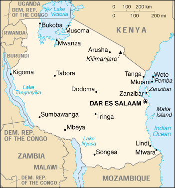
Location: Eastern Africa, bordering the Indian Ocean, between Kenya and Mozambique
Geographic coordinates: 6 00 S, 35 00 E
Area:
total: 945,087 sq km
land: 886,037 sq km
water: 59,050 sq km
note: includes the islands of Mafia, Pemba, and Zanzibar
Land boundaries:
total: 3,402 km
border countries: Burundi 451 km, Kenya 769 km, Malawi 475 km, Mozambique 756 km, Rwanda 217 km, Uganda 396 km, Zambia 338 km
Coastline: 1,424 km
Maritime claims:
exclusive economic zone: 200 nm
territorial sea: 12 nm
Climate: varies from tropical along coast to temperate in highlands
Terrain: plains along coast; central plateau; highlands in north, south
Elevation extremes:
lowest point: Indian Ocean 0 m
highest point: Kilimanjaro 5,895 m
Natural resources: hydropower, tin, phosphates, iron ore, coal, diamonds, gemstones, gold, natural gas, nickel
Land use:
arable land: 3%
permanent crops: 1%
permanent pastures: 40%
forests and woodland: 38%
other: 18% (1993 est.)
Irrigated land: 1,500 sq km (1993 est.)
Natural hazards: the tsetse fly; flooding on the central plateau during the rainy season; drought
Environment – current issues: soil degradation; deforestation; desertification; destruction of coral reefs threatens marine habitats; recent droughts affected marginal agriculture
Environment – international agreements:
party to: Biodiversity, Climate Change, Desertification, Endangered Species, Hazardous Wastes, Law of the Sea, Ozone Layer Protection, Wetlands
signed, but not ratified: Nuclear Test Ban
Geography – note: Kilimanjaro is highest point in Africa; bordered by three of the largest lakes on the continent: Lake Victoria (the world’s second-largest freshwater lake) in the north, Lake Tanganyika (the world’s second deepest) in the west, and Lake Nyasa in the southwest.
People of Tanzania
Population distribution in Tanzania is extremely uneven. Density varies from 1 person per square kilometer (3 per sq. mi.) in arid regions to 51 per square kilometer (133 per sq. mi.) in the mainland’s well-watered highlands and 134 per square kilometer (347 per sq. mi.) on Zanzibar. More than 80% of the population is rural. Dar es Salaam is the capital and largest city; Dodoma, located in the center of Tanzania, has been designated the new capital, although action to move the capital has stalled.
The African population consists of more than 120 ethnic groups, of which the Sukuma, Haya, Nyakyusa, Nyamwezi, and Chaga have more than 1 million members The majority of Tanzanians, including such large tribes as the Sukuma and the Nyamwezi are of Bantu stock. Groups of Nilotic or related origin include the nomadic Masai and the Luo, both of which are found in greater numbers in neighboring Kenya. Two small groups speak languages of the Khoisan family peculiar to the Bushman and Hottentot peoples. Cushitic-speaking peoples, originally from the Ethiopian highlands, reside in a few areas of Tanzania.
Although much of Zanzibar’s African population came from the mainland, one group known as Shirazis traces its origins to the island’s early Persian settlers. Non-Africans residing on the mainland and Zanzibar account for 1% of the total population. The Asian community, including Hindus, Sikhs, Shi’a and Sunni Muslims, and Goans, has declined by 50% in the past decade to 50,000 on the mainland and 4,000 on Zanzibar. An estimated 70,000 Arabs and 10,000 Europeans reside in Tanzania.
Each ethnic group has its own language, but the national language is Kiswahili, a Bantu-based tongue with strong Arabic borrowings.
Population: 36,766,356 (July 2005 est.)
Age structure:
0-14 years: 45%
15-64 years: 52%
65 years and over: 3%
Population growth rate: 2.57%
Birth rate: 40.17 births/1,000 population
Death rate: 12.88 deaths/1,000 population
Net migration rate: -1.59 migrant(s)/1,000 population
Infant mortality rate: 80.97 deaths/1,000 live births
Life expectancy at birth:
total population: 52.26 years
male: 51.32 years
female: 53.23 years
Total fertility rate: 5.51 children born/woman
Nationality:
noun: Tanzanian(s)
adjective: Tanzanian
Ethnic groups: mainland – native African 99% (of which 95% are Bantu consisting of more than 130 tribes), other 1% (consisting of Asian, European, and Arab); Zanzibar – Arab, native African, mixed Arab and native African
Religions: mainland – Christian 45%, Muslim 35%, indigenous beliefs 20%; Zanzibar – more than 99% Muslim
Languages: Kiswahili or Swahili (official), Kiunguju (name for Swahili in Zanzibar), English (official, primary language of commerce, administration, and higher education), Arabic (widely spoken in Zanzibar), many local languages
note: Kiswahili (Swahili) is the mother tongue of the Bantu people living in Zanzibar and nearby coastal Tanzania; although Kiswahili is Bantu in structure and origin, its vocabulary draws on a variety of sources, including Arabic and English, and it has become the lingua franca of central and eastern Africa; the first language of most people is one of the local languages
Literacy:
definition: age 15 and over can read and write Kiswahili (Swahili), English, or Arabic
total population: 67.8%
male: 79.4%
female: 56.8% (1995 est.)
History of Tanzania
Tanganyika/Tanzania
Northern Tanganyika’s famed Olduvai Gorge has provided rich evidence of the area’s prehistory, including fossil remains of some of humanity’s earliest ancestors. Discoveries suggest that East Africa may have been the site of human origin.
Little is known of the history of Tanganyika’s interior during the early centuries of the Christian era. The area is believed to have been inhabited originally by ethnic groups using a click-tongue language similar to that of Southern Africa’s Bushmen and Hottentots. Although remnants of these early tribes still exist, most were gradually displaced by Bantu farmers migrating from the west and south and by Nilotes and related northern peoples. Some of these groups had well-organized societies and controlled extensive areas by the time the Arab slavers, European explorers, and missionaries penetrated the interior in the first half of the 19th century.
The coastal area first felt the impact of foreign influence as early as the 8th century, when Arab traders arrived. By the 12th century, traders and immigrants came from as far away as Persia (now Iran) and India. They built a series of highly developed city and trading states along the coast, the principal one being Kibaha, a settlement of Persian origin that held ascendancy until the Portuguese destroyed it in the early 1500s.
The Portuguese navigator Vasco da Gama explored the East African coast in 1498 on his voyage to India. By 1506, the Portuguese claimed control over the entire coast. This control was nominal, however, because the Portuguese did not colonize the area or explore the interior. Assisted by Omani Arabs, the indigenous coastal dwellers succeeded in driving the Portuguese from the area north of the Ruvuma River by the early 18th century. Claiming the coastal strip, Omani Sultan Seyyid Said (l804-56) moved his capital to Zanzibar in 1841.
European exploration of the interior began in the mid-19th century. Two German missionaries reached Mt. Kilimanjaro in the 1840s. British explorers Richard Burton and John Speke crossed the interior to Lake Tanganyika in 1857. David Livingstone, the Scottish missionary-explorer who crusaded against the slave trade, established his last mission at Ujiji, where he was “found” by Henry Morton Stanley, an American journalist-explorer, who had been commissioned by the New York Herald to locate him.
German colonial interests were first advanced in 1884. Karl Peters, who formed the Society for German Colonization, concluded a series of treaties by which tribal chiefs in the interior accepted German “protection.” Prince Otto is von Bismarck’s government backed Peters in the subsequent establishment of the German East Africa Company.
In 1886 and 1890, Anglo-German agreements were negotiated that delineated the British and German spheres of influence in the interior of East Africa and along the coastal strip previously claimed by the Omani sultan of Zanzibar. In 1891, the German Government took over direct administration of the territory from the German East Africa Company and appointed a governor with headquarters at Dar es Salaam.
Although the German colonial administration brought cash crops, railroads, and roads to Tanganyika, European rule provoked African’s resistance, culminating in the Maji Maji rebellion of 1905-07. The rebellion, which temporarily united a number of southern tribes and ended only after an estimated 120,000 Africans had died from fighting or starvation, is considered by most Tanzanians to have been one of the first stirrings of nationalism.
German colonial domination of Tanganyika ended after World War I when control of most of the territory passed to the United Kingdom under a League of Nations mandate. After World War II, Tanganyika became a UN trust territory under British control. Subsequent years witnessed Tanganyika moving gradually toward self-government and independence.
In 1954, Julius K. Nyerere, a school teacher who was then one of only two Tanganyikans educated abroad at the university level, organized a political party–the Tanganyika African National Union (TANU). TANU-supported candidates were victorious in the Legislative Council elections of September 1958 and February 1959. In December 1959, the United Kingdom agreed to the establishment of internal self-government following general elections to be held in August 1960. Nyerere was named chief minister of the subsequent government.
In May l961, Tanganyika became autonomous, and Nyerere became Prime Minister under a new constitution. Full independence was achieved on December 9, 1961. Mr. Nyerere was elected President when Tanganyika became a republic within the Commonwealth a year after independence.
Zanzibar
An early Arab/Persian trading center, Zanzibar fell under Portuguese domination in the 16th and early 17th centuries but was retaken by Omani Arabs in the early 18th century. The height of Arab rule came during the reign of Sultan Seyyid Said, who encouraged the development of clove plantations, using the island’s slave labor.
The Arabs established their own garrisons at Zanzibar, Pemba, and Kilwa and carried on a lucrative trade in slaves and ivory. By 1840, Said had transferred his capital from Muscat to Zanzibar and established a ruling Arab elite. The island’s commerce fell increasingly into the hands of traders from the Indian subcontinent, whom Said encouraged to settle on the island.
Zanzibar’s spices attracted ships from as far away as the United States. A U.S. consulate was established on the island in 1837. The United Kingdom’s early interest in Zanzibar was motivated by both commerce and the determination to end the slave trade. In 1822, the British signed the first of a series of treaties with Sultan Said to curb this trade, but not until 1876 was the sale of slaves finally prohibited.
The Anglo-German agreement of 1890 made Zanzibar and Pemba a British protectorate. British rule through a Sultan remained largely unchanged from the late 19th century until after World War II.
Zanzibar’s political development began in earnest after 1956, when provision was first made for the election of six nongovernment members to the Legislative Council. Two parties were formed: the Zanzibar Nationalist Party (ZNP), presenting the dominant Arab and “Arabized” minority and the Afro-Shirazi Party (ASP), led by Abaid Karume and representing the Shirazis and the African majority.
The first elections were held in July 1957. The ASP won three of the six elected seats, with the remainder going to independents. Following the election, the ASP split; some of its Shirazi supporters left to form the Zanzibar and Pemba People’s Party (ZPPP). The January 1961 election resulted in a deadlock between the ASP and a ZNP-ZPPP coalition.
On April 26,1964, Tanganyika union with Zanzibar to form the United Republic of Tanganyika and Zanzibar, renamed the United Republic of Tanzania on October 29.
United Republic of Tanzania
TANU and the Afro-Shirazi Party of Zanzibar were merged into a single party (Chama cha Mapinduzi-CCM Revolutionary Party) on February 5, 1977. On April 26, 1977, the union of the two parties was ratified in a new constitution. The merger was reinforced by principles enunciated in the 1982 union constitution and reaffirmed in the constitution of 1984.
The elections that followed the granting of self-government in June 1963 produced similar results. Zanzibar received its independence from the United Kingdom on December 19, 1963, as a constitutional monarchy under the sultan. On January 12, 1964, the African majority revolted against the sultan and a new government was formed with the ASP leader, Abeid Karume, as President of Zanzibar and Chairman of the Revolutionary Council. Under the terms of its political union with Tanganyika in April 1964, the Zanzibar Government retained considerable local autonomy.
In 1977, Nyerere merged TANU with the Zanzibar ruling party, the ASP, to form the CCM as the sole ruling party in both parts of the union. The CCM was to be the sole instrument for mobilizing and controlling the population in all significant political or economic activities. He envisioned the party as a “two-way street” for the flow of ideas and policy directives between the village level and the government.
President Nyerere stepped down from office and was succeeded as President by Ali Hassan Mwinyi in 1985. Nyerere retained his position as Chairman of the ruling party for 5 more years and was influential in Tanzanian politics until his death in October 1999. The current President, Benjamin Mkapa, was elected in 1995 and will stand for re-election in nationwide balloting scheduled for October 2000. Zanzibar President Salmin Amour was elected in single-party elections in 1990. In 1995, he was named the winner of Zanzibar’s first multi-party elections, a victory widely deemed to have been tainted by fraud. He is not eligible to run for a third term.
Tanzania Economy
Economy – overview: Tanzania is one of the poorest countries in the world. The economy is heavily dependent on agriculture, which accounts for half of GDP, provides 85% of exports, and employs 80% of the work force. Topography and climatic conditions, however, limit cultivated crops to only 4% of the land area. Industry is mainly limited to processing agricultural products and light consumer goods. The World Bank, the International Monetary Fund, and bilateral donors have provided funds to rehabilitate Tanzania’s deteriorated economic infrastructure. Growth in 1991-2000 featured a pick up in industrial production and a substantial increase in output of minerals, led by gold. Natural gas exploration in the Rufiji Delta looks promising and production could start by 2002. Recent banking reforms have helped increase private sector growth and investment. Continued donor support and solid macroeconomic policies should allow Tanzania to achieve real GDP growth of 6% in 2001 and in 2002.
GDP: purchasing power parity – $25.1 billion (2000 est.)
GDP – real growth rate: 4% (1999 est.), 5.2% (2000 est.)
GDP – per capita: purchasing power parity – $710 (2000 est.)
GDP – composition by sector:
agriculture: 49%
industry: 17%
services: 34% (1996 est.)
Population below poverty line: 51.1% (1991 est.)
Household income or consumption by percentage share:
lowest 10%: 2.9%
highest 10%: 30.2% (1993)
Inflation rate (consumer prices): 8.8% (1999 est.)
Labor force: 13.495 million
Labor force – by occupation: agriculture 90%, industry and commerce 10% (1995 est.)
Budget:
revenues: $1 billion
expenditures: $1.3 billion (1999 est.)
Industries: primarily agricultural processing (sugar, beer, cigarettes, sisal twine), diamond and gold mining, oil refining, shoes, cement, textiles, wood products, fertilizer, salt
Industrial production growth rate: 8.4% (1999 est.)
Electricity – production: 1.7 billion kWh (1998)
Electricity – production by source:
fossil fuel: 29.41%
hydro: 70.59%
nuclear: 0%
other: 0% (1998)
Electricity – consumption: 1.625 billion kWh (1998)
Electricity – exports: 0 kWh (1998)
Electricity – imports: 44 million kWh (1998)
Agriculture – products: coffee, sisal, tea, cotton, pyrethrum (insecticide made from chrysanthemums), cashew nuts, tobacco, cloves (Zanzibar), corn, wheat, cassava (tapioca), bananas, fruits, vegetables; cattle, sheep, goats
Exports: $828 million (f.o.b., 1999 est.)
Exports – commodities: coffee, manufactured goods, cotton, cashew nuts, minerals, tobacco, sisal (1996)
Exports – partners: India 9.8%, Germany 8.9%, Japan 7.8%, Malaysia 6.5%, Rwanda 5.2%, Netherlands 4.7% (1997)
Imports: $1.44 billion (f.o.b., 1999 est.)
Imports – commodities: consumer goods, machinery and transportation equipment, industrial raw materials, crude oil
Imports – partners: South Africa 12.9%, Kenya 9.6%, United Kingdom 8.7%, Saudi Arabia 6.6%, Japan 4.9%, China 4.6% (1997)
Debt – external: $7.7 billion (1999 est.)
Economic aid – recipient: $963 million (1997)
Currency: 1 Tanzanian shilling (TZS) = 100 cents
Map of Tanzania