Facts About Turkmenistan
Background: Annexed by Russia between 1865 and 1885, Turkmenistan became a Soviet republic in 1925. It achieved its independence upon the dissolution of the USSR in 1991. President NIYAZOV retains absolute control over the country and opposition is not tolerated. Extensive hydrocarbon/natural gas reserves could prove a boon to this underdeveloped country if extraction and delivery projects can be worked out.
Government type: republic
Capital: Ashgabat
Currency: 1 Turkmen manat (TMM) = 100 tenesi
Geography of Turkmenistan
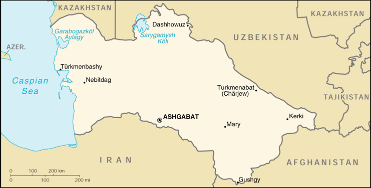
Location: Central Asia, bordering the Caspian Sea, between Iran and Kazakhstan
Geographic coordinates: 40 00 N, 60 00 E
Area:
total: 488,100 sq km
land: 488,100 sq km
water: 0 sq km
Land boundaries:
total: 3,736 km
border countries: Afghanistan 744 km, Iran 992 km, Kazakhstan 379 km, Uzbekistan 1,621 km
Coastline: 0 km
note: Turkmenistan borders the Caspian Sea (1,768 km)
Maritime claims: none (landlocked)
Climate: subtropical desert
Terrain: flat-to-rolling sandy desert with dunes rising to mountains in the south; low mountains along border with Iran; borders Caspian Sea in west
Elevation extremes:
lowest point: Vpadina Akchanaya -81 m (note – Sarygamysh Koli is a lake in north eastern Turkmenistan whose water levels fluctuate widely; at its shallowest, its level is -110 m; it is presently at -60 m, 20 m above Vpadina Akchanaya)
highest point: Ayrybaba 3,139 m
Natural resources: petroleum, natural gas, coal, sulfur, salt
Land use:
arable land: 3%
permanent crops: 0%
permanent pastures: 63%
forests and woodland: 8%
other: 26% (1993 est.)
Irrigated land: 13,000 sq km (1993 est.)
Environment – current issues: contamination of soil and groundwater with agricultural chemicals, pesticides; salination, water-logging of soil due to poor irrigation methods; Caspian Sea pollution; diversion of a large share of the flow of the Amu Darya into irrigation contributes to that river’s inability to replenish the Aral Sea; desertification
Environment – international agreements:
party to: Biodiversity, Climate Change, Climate Change-Kyoto Protocol, Desertification, Hazardous Wastes, Ozone Layer Protection
signed, but not ratified: none of the selected agreements
Geography – note: landlocked; the western and central low-lying, desolate portions of the country make up the great Garagum (Kara-Kum) desert, which occupies over 80% of the country; eastern part is plateau.
People of Turkmenistan
Population: 4,952,081 (July 2005 est.)
Age structure:
0-14 years: 38%
15-64 years: 58%
65 years and over: 4%
Population growth rate: 1.87%
Birth rate: 28.88 births/1,000 population
Death rate: 9.04 deaths/1,000 population
Net migration rate: -1.11 migrant(s)/1,000 population
Infant mortality rate: 73.3 deaths/1,000 live births
Life expectancy at birth:
total population: 60.91 years
male: 57.29 years
female: 64.71 years
Total fertility rate: 3.63 children born/woman
Nationality:
noun: Turkmen(s)
adjective: Turkmen
Ethnic groups: Turkmen 77%, Uzbek 9.2%, Russian 6.7%, Kazakh 2%, other 5.1% (1995)
Religions: Muslim 89%, Eastern Orthodox 9%, unknown 2%
Languages: Turkmen 72%, Russian 12%, Uzbek 9%, other 7%
Literacy:
definition: age 15 and over can read and write
total population: 98%
male: 99%
female: 97% (1989 est.)
History of Turkmenistan
DURING MUCH OF ITS PAST, Turkmenistan has received little attention from the outside world. Apart from its role in establishing the Seljuk dynasty in the Middle East in the Middle Ages, for most of its history this territory was not a coherent nation but a geographically defined region of independent tribal groups and other political entities. Like other republics of the former Soviet Union, Turkmenistan has emerged on the world scene as a newly independent country in need of both national and international acceptance, security, and development.
Turkmenistan’s authoritarian regime and regional social structure have produced the most politically and economically stable of the former Soviet republics. Although its leadership has gained a reputation abroad for repression of political opposition, it is perceived at home as promoting the social benefits, national traditions, and security of the Turkmen people. In addition, to ensure its national security and trade prospects, Turkmenistan has charted an independent course in establishing a military alliance with Russia and trade and security agreements with Iran and Central Asian countries. In terms of natural assets, Turkmenistan is a landlocked, desert country beneath whose surface lie substantial deposits of oil and the fifth largest reserves of natural gas in the world. Foreign investors, attracted by the republic’s calm and receptive atmosphere, have sidestepped human rights issues on their way to establishing joint exploitation of Turkmenistan’s rich energy resources.
Turkmenistan was known for most of its history as a loosely defined geographic region of independent tribes. Now it is a landlocked, mostly desert nation of only about 3.8 million people (the smallest population of the Central Asian republics in the second-largest land mass). The country remains quite isolated on the eastern shore of the Caspian Sea, largely occupied by the Qizilqum (Kyzyl Kum) Desert. Traditional tribal relationships still are a fundamental base of society, and telecommunications service from the outside world has only begun to have an impact. Like the Kazaks and the Kyrgyz, the Turkmen peoples were nomadic herders until the second half of the nineteenth century, when the arrival of Russian settlers began to deprive them of the vast expanses needed for livestock.
Agriculture contributes about half of Turkmenistan’s GDP, whereas industry accounts for only about one-fifth. However, irrigation is necessary for nearly all the republic’s arable land. In the early 1990s, government subsidies protected consumers from the shock of leaving the insulated Soviet system. Nevertheless, the standard of living protected by those subsidies had been among the lowest in the Soviet Union, and it deteriorated further in the 1990s. Although the Niyazov regime launched ambitious privatization programs in 1992 and 1993–with energy, transportation, agriculture, and communications to remain under state control–only minor progress had been made toward the programs’ goals by the mid-1990s. Progress also has been quite slow in the reform of commercial and banking legislation.
Turkmenistan played a vital role in the Soviet system as a natural gas supplier. In the post-Soviet period, Russia remained the republic’s top trade partner, with Turkey moving into second place in the mid-1990s. A crucial rail link with Iran also was an important commercial improvement.
The single most important mineral resource is natural gas; Turkmenistan’s reserves may be among the largest in the world, with estimates as high as 15 trillion cubic meters. Nearly all the republic has been identified as potentially productive, and important offshore reserves exist in the Caspian Sea. The second major resource is petroleum, of which Turkmenistan has an estimated 63 billion tons. However, the range of the republic’s mineral resources is small: sulfur, mineral salts, and clays complete the list.
In the mid-1990s, Turkmenistan’s economic policy continued to rely heavily on the West’s demand for natural gas. But, for a nation isolated along the east coast of the Caspian Sea, gas sales depend strictly on pipeline movement. Existing lines, built to serve the Turkmenistan-Russia north-south axis, cannot fill this need. New lines moving from east to west have been planned, but all plans encounter strong geopolitical opposition from a regional power or from the United States. Until the pipeline problem is solved, Turkmenistan can sell gas only to the same customers it served in the Soviet era, who now are its impoverished fellow members of the CIS. Armenia and Ukraine, major CIS customers, have been chronically late in paying. In February 1996, Turkmenistan made a long-term agreement to sell as much as 15 billion cubic meters of gas per year to Turkey between 1998 and 2020. Turkey also received development rights for a field in Turkmenistan believed to contain 20 million tons of oil.
Many recent economic indicators can only be approximated because Turkmenistan has not issued precise statistics. The national currency, the manat, was devalued in late 1995 from a ratio of 500 to US$1 to 2,100 to US$1; it has remained non-convertible. It is believed that inflation in 1995 exceeded 1,000 percent; the 1996 annual rate, 140 percent, still was the highest in Central Asia. Exports for 1995 were about US$1.9 billion and imports about US$1.5 billion in official estimates. However, Turkmenistan conducts much barter trade, and payment failures of gas customers further undermine the application of cash trade figures. For 1996 the Economist Intelligence Unit forecast a 5 percent reduction of GDP following a drop of 15 percent in 1995. It also forecast a reduction in inflation in 1996 to 800 percent and a further drop in the value of the manat to a rate of 3,000 to US$1.
The state still strongly dominates the national economy. Little private enterprise occurs without some form of government approval or support, and about 90 percent of the work force is in state enterprises. In 1996 plans called for modernization of tax and business laws, including joint-venture conditions for the oil and gas industries. Pending those developments, foreign investors face a mass of state bureaucracy.
Foreign investment has been small, and experts predict no short-term improvement, partly because of the republic’s insufficient legal and bureaucratic infrastructure, and partly because the very small and impoverished population provides little market opportunity. (The official average monthly wage was US$7 in early 1996.) The European Bank for Reconstruction and Development (EBRD) and other international banks are funding a textile complex, and Ashgabat Airport will be modernized with a loan of US$31 million from the British Export Credit Agency. However, for 1996 total direct investment was only US$32 million, with another US$61 million in joint ventures and US$161 million in foreign loans.
Turkmenistan has pursued the most independent and pragmatic foreign policy of the five Central Asian republics. The overall goal has been to form advantageous regional relationships without becoming involved in regional conflicts such as the Tajikistani civil war. In December 1996, Turkmenistan passed legislation declaring permanent neutrality and prohibiting membership in any military or political-military alliance entailing responsibilities for collective action by its members.
President Niyazov has run the country’s foreign policy personally; he has faced little pressure at home to orient policy in a particular direction. Thus, he has been able to form ties with diverse foreign nations, maintaining economic advancement as the primary goal. Through the mid-1990s, Iran has been the top regional partner, although national security relations with Russia also have been a high priority during that period. In 1995 Turkmenistan signed a series of bilateral agreements with Russia, expanding economic and political cooperation and proclaiming the two nations “strategic partners” through 2000.
Turkmenistan has explicitly avoided multilateral arrangements, most of them sponsored by Uzbekistan, with the other Central Asian republics. It refused membership in the Central Asian customs union established by Kazakstan, Kyrgyzstan, and Uzbekistan in 1994, and in the Central Asian Economic Union that sprang from the initial agreement. Turkmenistan also contributed nothing to the CIS peacekeeping force sent to Tajikistan by those three nations and Russia in 1993. Substantial tension has arisen with Uzbekistan over water consumption, competition on the world cotton market, the Uzbek minority population’s potential for unrest, and resentment of Uzbekistan’s ambitions for regional leadership. By the end of 1995, tensions with Uzbekistan were so high that Turkmenistan boycotted all regional meetings. However, in January 1996 a meeting of the two nations’ presidents produced a package of economic cooperation agreements, and new agreements on road and railroad transportation were discussed in the first half of 1996.
Turkmenistan Economy
Economy – overview: Turkmenistan is largely desert country with intensive agriculture in irrigated oases and huge gas (fifth largest reserves in the world) and oil resources. One-half of its irrigated land is planted in cotton, making it the world’s tenth largest producer. Until the end of 1993, Turkmenistan had experienced less economic disruption than other former Soviet states because its economy received a boost from higher prices for oil and gas and a sharp increase in hard currency earnings. In 1994, Russia’s refusal to export Turkmen gas to hard currency markets and mounting debts of its major customers in the former USSR for gas deliveries contributed to a sharp fall in industrial production and caused the budget to shift from a surplus to a slight deficit. With an authoritarian ex-communist regime in power and a tribally based social structure, Turkmenistan has taken a cautious approach to economic reform, hoping to use gas and cotton sales to sustain its inefficient economy. Privatization goals remain limited. In 1998-2000, Turkmenistan suffered from the continued lack of adequate export routes for natural gas and from obligations on extensive short-term external debt. At the same time, however, total exports rose sharply because of higher international oil and gas prices. Prospects in the near future are discouraging because of widespread internal poverty and the burden of foreign debt. IMF assistance would seem to be necessary, yet the government is not as yet ready to accept IMF requirements. Turkmenistan’s 1999 deal to ship 20 billion cubic meters (bcm) of natural gas through Russia’s Gazprom pipeline helped alleviate the 2000 fiscal shortfall. Inadequate fiscal restraint and the tenuous nature of Turkmenistan’s 2001 gas deals, combined with a lack of economic reform, will limit progress in the near term.
GDP: purchasing power parity – $19.6 billion (2000 est.)
GDP – real growth rate: 9% (1999 est.), 16% (2000 est.)
GDP – per capita: purchasing power parity – $4,300 (2000 est.)
GDP – composition by sector:
agriculture: 10%
industry: 62%
services: 28% (1997 est.)
Household income or consumption by percentage share:
lowest 10%: 2.7%
highest 10%: 26.9% (1993)
Inflation rate (consumer prices): 30% (1999 est.)
Labor force: 2.34 million (1996)
Labor force – by occupation: agriculture and forestry 44%, industry and construction 19%, other 37% (1996)
Budget:
revenues: $521 million
expenditures: $548 million, including capital expenditures of $83 million (1996 est.)
Industries: natural gas, oil, petroleum products, textiles, food processing
Electricity – production: 8.745 billion kWh (1998)
Electricity – production by source:
fossil fuel: 99.94%
hydro: 0.06%
nuclear: 0%
other: 0% (1998)
Electricity – consumption: 5.453 billion kWh (1998)
Electricity – exports: 2.74 billion kWh (1998)
Electricity – imports: 60 million kWh (1998)
Agriculture – products: cotton, grain; livestock
Exports: $1.1 billion (1999 est.)
Exports – commodities: oil and gas 55%, cotton 22% (1998)
Exports – partners: Iran, Turkey, Russia, Kazakhstan, Tajikistan, Azerbaijan
Imports: $1.25 billion (1999 est.)
Imports – commodities: machinery and equipment 45%, chemicals, foodstuffs (1998)
Imports – partners: Ukraine, Turkey, Russia, Germany, United States, Kazakhstan, Uzbekistan
Debt – external: $2.1 billion (1999 est.)
Economic aid – recipient: $27.2 million (1995)
Currency: 1 Turkmen manat (TMM) = 100 tenesi
Map of Turkmenistan