Background: Independence from the UK was approved in 1960 with constitutional guarantees by the Greek Cypriot majority to the Turkish Cypriot minority. In 1974, a Greek-sponsored attempt to seize the government was met by military intervention from Turkey, which soon controlled almost 40% of the island. In 1983, the Turkish-held area declared itself the “Turkish Republic of Northern Cyprus”, but it is recognized only by Turkey. UN-led talks on the status of Cyprus resumed in December 1999 to prepare the ground for meaningful negotiations leading to a comprehensive settlement.
Government type: republic
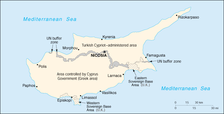
note: a disaggregation of the two ethnic communities inhabiting the island began following the outbreak of communal strife in 1963; this separation was further solidified after the Turkish intervention in July 1974 after a Greek junta-based coup attempt gave the Turkish Cypriots de facto control in the north; Greek Cypriots control the only internationally recognized government; on 15 November 1983 Turkish Cypriot “President” Rauf DENKTASH declared independence and the formation of a “Turkish Republic of Northern Cyprus” (TRNC), recognized only by Turkey; both sides publicly support a settlement based on a federation (Greek Cypriot position) or confederation (Turkish Cypriot position).
Capital: Nicosia
Currency: Greek Cypriot area: 1 Cypriot pound = 100 cents; Turkish Cypriot area: 1 Turkish lira (TL) = 100 kurus
Geography of Cyprus
Location: Middle East, island in the Mediterranean Sea, south of Turkey
Geographic coordinates: 35 00 N, 33 00 E
Area:
total: 9,250 sq. km (of which 3,355 sq km are in the Turkish Cypriot area)
land: 9,240 sq. km
water: 10 sq. km
Land boundaries: 0 km
Coastline: 648 km
Maritime claims:
continental shelf: 200-m depth or to the depth of exploitation
territorial sea: 12 nm
Climate: temperate, Mediterranean with hot, dry summers and cool, winters
Terrain: central plain with mountains to north and south; scattered but significant plains along southern coast
Elevation extremes:
lowest point: Mediterranean Sea 0 m
highest point: Olympus 1,951 m
Natural resources: copper, pyrites, asbestos, gypsum, timber, salt, marble, clay earth pigment
Land use:
arable land: 12%
permanent crops: 5%
permanent pastures: 0%
forests and woodland: 13%
other: 70% (1993 est.)
Irrigated land: 390 sq. km (1993 est.)
Natural hazards: moderate earthquake activity
Environment – current issues: water resource problems (no natural reservoir catchments, seasonal disparity in rainfall, sea water intrusion to island’s largest aquifer, increased salination in the north); water pollution from sewage and industrial wastes; coastal degradation; loss of wildlife habitats from urbanization.
Environment – international agreements:
party to: Air Pollution, Biodiversity, Climate Change, Climate Change-Kyoto Protocol, Desertification, Endangered Species, Environmental Modification, Hazardous Wastes, Law of the Sea, Marine Dumping, Nuclear Test Ban, Ozone Layer Protection, Ship Pollution
signed, but not ratified: Air Pollution-Persistent Organic Pollutants
Geography – note: Cyprus is the third largest island in the Mediterranean Sea (after Sicily and Sardinia).
The physical setting for life on the island is dominated by the mountain masses and the central plain they encompass, the Mesaoria. The Troodos Mountains cover most of the southern and western portions of the island and account for roughly half its area. The narrow Kyrenia Range, extending along the northern coastline, occupies substantially less area, and elevations are lower. The two mountain systems run generally parallel to the Taurus Mountains on the Turkish mainland, whose silhouette is visible from northern Cyprus. Coastal lowlands, varying in width, surround the island.
Terrain
The rugged Troodos Mountains, whose principal range stretches from Pomos Point in the northwest almost to Larnaca Bay on the east, are the single most conspicuous feature of the landscape. Intensive uplifting and folding in the formative period left the area highly fragmented, so that subordinate ranges and spurs veer off at many angles, their slopes incised by steep-sided valleys. In the southwest, the mountains descend in a series of stepped foothills to the coastal plain.
While the Troodos Mountains are a massif formed of molten igneous rock, the Kyrenia Range is a narrow limestone ridge that rises suddenly from the plains. Its easternmost extension becomes a series of foothills on the Karpas Peninsula. That peninsula points toward Asia Minor, to which Cyprus belongs geologically.
Even the highest peaks of the Kyrenia Range are hardly more than half the height of the great dome of the Troodos massif, Mount Olympus (1,952 meters), but their seemingly inaccessible, jagged slopes make them considerably more spectacular. British writer Lawrence Durrell, in Bitter Lemons, wrote of the Troodos as “an unlovely jumble of crags and heavyweight rocks” and of the Kyrenia Range as belonging to “the world of Gothic Europe, its lofty crags studded with crusader castles.”
Rich copper deposits were discovered in antiquity on the slopes of the Troodos. Geologists speculate that these deposits may have originally formed under the Mediterranean Sea, as a consequence of the upwelling of hot, mineral-laded water through a zone where plates that formed the ocean floor were pulling apart.
Drainage
Deforestation over the centuries has damaged the island’s drainage system and made access to a year-round supply of water difficult. A network of winter rivers rises in the Troodos Mountains and flows out from them in all directions. The Yialias River and the Pedhieos River flow eastward across the Mesaoria into Famagusta Bay; the Serraghis River flows northwest through the Morphou plain. All of the island’s rivers, however, are dry in the summer. An extensive system of dams and waterways has been constructed to bring water to farming areas.
The Mesaoria is the agricultural heartland of the island, but its productiveness for wheat and barley depends very much on winter rainfall; other crops are grown under irrigation. Little evidence remains that this broad, central plain, open to the sea at either end, was once covered with rich forests whose timber was coveted by ancient conquerors for their sailing vessels. The now-divided capital of the island, Nicosia, lies in the middle of this central plain.
Climate
The Mediterranean climate, warm and rather dry, with rainfall mainly between November and March, favors agriculture. In general, the island experiences mild wet winters and dry hot summers. Variations in temperature and rainfall are governed by altitude and, to a lesser extent, distance from the coast.
The higher mountain areas are cooler and moister than the rest of the island. They receive the heaviest annual rainfall, which may be as much as 1,000 millimeters. Sharp frost also occurs in the higher districts, which are usually blanketed with snow during the first months of the year. Plains along the northern coast and in the Karpas Peninsula area average 400 to 450 millimeters of annual rainfall. The least rainfall occurs in the Mesaoria, with 300 to 400 millimeters a year. Variability in annual rainfall is characteristic for the island, however, and droughts are frequent and sometimes severe. Earthquakes, usually not destructive, occur from time to time.
Summer temperatures are high in the lowlands, even near the sea, and reach particularly uncomfortable readings in the Mesaoria. Because of the scorching heat of the lowlands, some of the villages in the Troodos have developed as resort areas, with summer as well as winter seasons. The mean annual temperature for the island as a whole is about 20° C. The amount of sunshine the island enjoys enhances the tourist industry. On the Mesaoria in the eastern lowland, for example, there is bright sunshine 75 percent of the time. During the four summer months, there is an average of eleven and one-half hours of sunshine each day, and in the cloudiest winter months there is an average of five and one-half hours per day.
People of Cyprus
Greek and Turkish Cypriots share many customs but maintain distinct identities based on religion, language, and close ties with their respective motherlands. Greek is predominantly spoken in the south, Turkish in the north. English is widely used. Cyprus has a well-developed system of primary and secondary education. The majority of Cypriots earn their higher education at Greek, Turkish, British, or American universities. Private colleges and state-supported universities have been developed by both the Turkish and Greek communities.
Population: 780,133 (July 2005 est.)
Age structure:
0-14 years: 22.95%
15-64 years: 66.26%
65 years and over: 10.79%
Population growth rate: 0.59
Birth rate: 13.08 births/1,000 population
Death rate: 7.65 deaths/1,000 population
Net migration rate: 0.44 migrant(s)/1,000 population
Infant mortality rate: 7.89 deaths/1,000 live births
Life expectancy at birth:
total population: 76.89 years
male: 74.6 years
female: 79.3 years
Total fertility rate: 1.93 children born/woman
Nationality:
noun: Cypriot(s)
adjective: Cypriot
Ethnic groups: Greek 78% (99.5% of the Greeks live in the Greek Cypriot area; 0.5% of the Greeks live in the Turkish Cypriot area), Turkish 18% (1.3% of the Turks live in the Greek Cypriot area; 98.7% of the Turks live in the Turkish Cypriot area), other 4% (99.2% of the other ethnic groups live in the Greek Cypriot area; 0.8% of the other ethnic groups live in the Turkish Cypriot area).
Religions: Greek Orthodox 78%, Muslim 18%, Maronite, Armenian Apostolic, and other 4%
Languages: Greek, Turkish, English
Literacy:
definition: age 15 and over can read and write
total population: 94%
male: 98%
female: 91% (1987 est.)
History of Cyprus
THE REPUBLIC OF CYPRUS was established in 1960, after the former colony gained independence from the United Kingdom. Since 1974, however, a de facto division of the island has existed, with the Greek Cypriot community controlling 63 percent of the territory, and the Turkish Cypriots, backed by Turkish army units, 37 percent. The scene of constant anticolonial and intercommunal strife since the mid-1950s, Cyprus assumed an importance out of proportion to its size and population because of its strategic location and its impact on the national interests of other nations. The island’s location in the eastern Mediterranean Sea has made it easily accessible from Europe, Asia, and Africa since the earliest days of ships. Its timber and mineral resources made it important as a source of trade goods in the ancient world, but attracted conquerors, pirates, and adventurers in addition to merchants and settlers. About the middle of the second millennium B.C. Cyprus was subjected to foreign domination for the first time, and from then until 1960, almost without interruption, outside powers controlled the island and its people.
Christianity was introduced early in the Christian Era, when Cyprus was under Roman rule, by the apostles Paul, Mark, and Barnabas. The martyrdom of Barnabas and the later discovery of his tomb are particularly important events in the history of the Church of Cyprus and were instrumental in its becoming autocephalous rather than remaining subordinate to the patriarchate of Antioch. After doctrinal controversies split Christianity between East and West, the church survived 400 years of attempts by Roman Catholic rulers to force recognition of the authority of the pope in Rome. After Cyprus’s conquest by Ottoman Turks in the sixteenth century, the sees of the Orthodox bishops were reestablished, according to the Ottoman practice of governing through a millet (a community distinguished by religion) system. Provided a millet met the empire’s demands, its leaders enjoyed a degree of autonomy. The head of the Greek Cypriot millet, the archbishop, was therefore both a religious and a secular leader, and it was entirely consistent with historical tradition that, in the anticolonial struggle of the mid-1950s, Archbishop Makarios III emerged as the leader of the Greek Cypriots and was subsequently elected president of the new republic.
After Greece had won its independence from the Ottoman Empire in 1821, the idea of enosis (union with Greece) took hold among ethnic Greeks living in the Ionian and Aegean islands, Crete, Cyprus, and areas of Anatolia. Britain ceded the Ionian Islands to Greece in 1864, and after control of Cyprus passed from the Ottoman Empire to the British Empire in 1878, Greek Cypriots saw the ceding of the Ionian islands as a precedent for enosis for themselves. Under British rule, agitation for enosis varied with time. After World War II, in the era of the breakup of colonial empires, the movement gained strength, and Greek Cypriots spurned British liberalization efforts. In the mid-1950s, when anticolonial guerrilla activities began, Turkish Cypriots–who until that time had only rarely expressed opposition to enosis–began to agitate for taksim, or partition, and Greece and Turkey began actively to support their respective ethnic groups on the island.
After four years of guerrilla revolt by Greek Cypriots against the British, a compromise settlement was reached, in Zurich between Greece and Turkey and in London among representatives of Greece, Turkey, and Britain and the Greek and Turkish Cypriot communities. As a result of this settlement, Cyprus became an independent republic. Independence was marked on August 16, 1960. In separate communal elections Makarios became president, and Fazil Küçük, leader of the Turkish Cypriots, became vice president. In the early 1960s, political arguments over constitutional interpretation continually deadlocked the government. Greek Cypriots insisted on revision of the constitution and majority rule. Turkish Cypriots argued for strict constructionism, local autonomy, and the principle of minority veto. The result was stalemate. Intercommunal violence broke out in December 1963, and resulted in the segregation of the two ethnic communities and establishment of the United Nations Peace-keeping Force in Cyprus (UNFICYP). Even with United Nations (UN) troops as a buffer, however, intermittent conflict continued and brought Greece and Turkey to the brink of war in 1964 and 1967.
The irony of the divided Cyprus that has existed since 1974 is that the stage was set for Turkish intervention by the Greek government in Athens. The military junta that controlled Greece came to view Archbishop Makarios as an obstacle to settlement of the Cyprus problem and establishment of better relations between Athens and Ankara. A successful coup was engineered in Cyprus in July 1974, Makarios was ousted, and a puppet president installed. Turkey, as one of the guarantor powers according to the agreements that led to Cypriot independence, sent troops into Cyprus to restore order. Britain, as another guarantor power, refused to participate. Meanwhile, in Greece the junta had collapsed, and a new government was being established. After a short cease-fire and a few days of hurried negotiations, the Turkish government reinforced its troops and ordered them to secure the northern part of the island.
Turkish forces seized 37 percent of the island and effected a de facto partition that was still in existence at the beginning of the 1990s. Turkish Cypriots declared the establishment of their own state in 1983, but as of 1990 only Turkey had recognized the “Turkish Republic of Northern Cyprus.” Although more populous and considerably richer, and enjoying international recognition, the Republic of Cyprus had not been able to regain its lost territory. Increased military expenditures could not offset the considerable Turkish military presence on the island. Years of laborious negotiations at numerous venues had also achieved little toward ending the island’s tragic division.
Cyprus Economy
Economy – overview: Economic affairs are affected by the division of the country. The Greek Cypriot economy is prosperous but highly susceptible to external shocks. Erratic growth rates in the 1990s reflect the economy’s vulnerability to swings in tourist arrivals, caused by political instability on the island and fluctuations in economic conditions in Western Europe. Economic policy is focused on meeting the criteria for admission to the EU. As in the Turkish sector, water shortage is a growing problem, and several desalination plants are planned. The Turkish Cypriot economy has about one-fifth the population and one-third the per capita GDP of the south. Because it is recognized only by Turkey, it has had much difficulty arranging foreign financing, and foreign firms have hesitated to invest there. It remains heavily dependent on agriculture and government service, which together employ about half of the work force. Moreover, the small, vulnerable economy has suffered because the Turkish lira is legal tender. To compensate for the economy’s weakness, Turkey provides direct and indirect aid to tourism, education, industry, etc.
GDP: Greek Cypriot area: purchasing power parity – $9.7 billion (2000 est.); Turkish Cypriot area: purchasing power parity – $830 million (1999 est.)
GDP – real growth rate: Greek Cypriot area: 4.2% (2000 est.); Turkish Cypriot area: 4.9% (1999 est.)
GDP – per capita: Greek Cypriot area: purchasing power parity – $16,000 (2000 est.); Turkish Cypriot area: purchasing power parity – $5,300 (1999 est.)
GDP – composition by sector: Greek Cypriot area: agriculture 6.3%, industry 22.4%, services 71.3%; Turkish Cypriot area: agriculture 11.8%, industry 20.5%, services 67.7% (1998)
Inflation rate (consumer prices): Greek Cypriot area: 4.2% (2000 est.); Turkish Cypriot area: 58% (1999 est.)
Labor force: Greek Cypriot area: 291,000; Turkish Cypriot area: 86,300 (2000)
Labor force – by occupation: Greek Cypriot area: services 73%, industry 22%, agriculture 5% (2000); Turkish Cypriot area: services 56.4%, industry 22.8%, agriculture 20.8% (1998)
Unemployment rate: Greek Cypriot area: 3.6% (2000 est.); Turkish Cypriot area: 6% (1998 est.)
Budget:
revenues: Greek Cypriot area – $2.9 billion (2000 est.); Turkish Cypriot area – $294 million (2000 est.)
expenditures: Greek Cypriot area – $3.2 billion, including capital expenditures of $324 million (2000 est.); Turkish Cypriot $495 million, including capital expenditures of $60 million (2000 est.)
Industries: food, beverages, textiles, chemicals, metal products, tourism, wood products
Industrial production growth rate: Greek Cypriot area: 2.2% (1999); Turkish Cypriot area: -0.3% (1999)
Electricity – production: 2.951 billion kWh (1999)
Electricity – production by source:
fossil fuel: 100%
hydro: 0%
nuclear: 0%
other: 0% (1999)
Agriculture – products: potatoes, citrus, vegetables, barley, grapes, olives, vegetables
Exports: Greek Cypriot area: $1 billion (f.o.b., 1999 est.); Turkish Cypriot area: $51.1 million (f.o.b., 1999)
Exports – commodities: Greek Cypriot area: citrus, potatoes, grapes, wine, cement, clothing and shoes; Turkish Cypriot area: citrus, potatoes, textiles
Exports – partners: Greek Cypriot area: UK 17.3%, Greece 9.7%, Russia 7.0%, Lebanon 5.2% (1999); Turkish Cypriot area: Turkey 51%, UK 31%, other EU 16.5% (1999)
Imports: Greek Cypriot area: $3.6 billion (f.o.b., 1999 est.); Turkish Cypriot area: $402 million (f.o.b., 1999)
Imports – commodities: Greek Cypriot area: consumer goods, petroleum and lubricants, food and feed grains, machinery; Turkish Cypriot area: food, minerals, chemicals, machinery
Imports – partners: Greek Cypriot area: UK 11.2%, US 10.6%, Italy 8.8%, Greece 8.2%, Germany 6.7% (1999); Turkish Cypriot area: Turkey 58.6%, UK 12.5%, other EU 13% (1999)
Debt – external: Greek Cypriot area: $1.27 billion (1998)
Economic aid – recipient: Greek Cypriot area – $17 million (1998); Turkish Cypriot area – $700 million from Turkey in grants and loans (1990-97) that are usually forgiven
Currency: Greek Cypriot area: Cypriot pound (CYP); Turkish Cypriot area: Turkish lira (TRL)
Map of Cyprus