Background: Formed from the merger of the British colony of the Gold Coast and the Togoland trust territory, Ghana in 1957 became the first country in colonial Africa to gain its independence. A long series of coups resulted in the suspension of the constitution in 1981 and the banning of political parties. A new constitution, restoring multiparty politics, was approved in 1992. Lt. Jerry RAWLINGS, head of state since 1981, won presidential elections in 1992 and 1996, but was constitutionally prevented from running for a third term in 2000. He was succeeded by John KUFUOR.
Government type: constitutional democracy
Capital: Accra
Currency: 1 new cedi (C) = 100 pesewas
Geography of Ghana
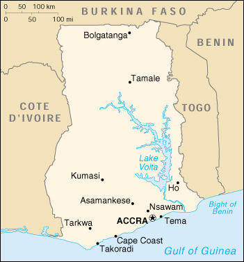
Location: Western Africa, bordering the Gulf of Guinea, between Cote d’Ivoire and Togo
Geographic coordinates: 8 00 N, 2 00 W
Area:
total: 238,540 sq. km
land: 230,020 sq. km
water: 8,520 sq. km
Land boundaries:
total: 2,093 km
border countries: Burkina Faso 548 km, Cote d’Ivoire 668 km, Togo 877 km
Coastline: 539 km
Maritime claims:
contiguous zone: 24 nm
continental shelf: 200 nm
exclusive economic zone: 200 nm
territorial sea: 12 nm
Climate: tropical; warm and comparatively dry along southeast coast; hot and humid in southwest; hot and dry in north
Terrain: mostly low plains with dissected plateau in south-central area
Elevation extremes:
lowest point: Atlantic Ocean 0 m
highest point: Mount Afadjato 880 m
Natural resources: gold, timber, industrial diamonds, bauxite, manganese, fish, rubber, hydropower
Land use:
arable land: 12%
permanent crops: 7%
permanent pastures: 22%
forests and woodland: 35%
other: 24% (1993 est.)
Irrigated land: 60 sq. km (1993 est.)
Natural hazards: dry, dusty, harmattan winds occur from January to March; droughts
Environment – current issues: recent drought in north severely affecting agricultural activities; deforestation; overgrazing; soil erosion; poaching and habitat destruction threatens wildlife populations; water pollution; inadequate supplies of potable water.
Environment – international agreements:
party to: Biodiversity, Climate Change, Desertification, Endangered Species, Environmental Modification, Law of the Sea, Nuclear Test Ban, Ozone Layer Protection, Ship Pollution, Tropical Timber 83, Tropical Timber 94, Wetlands
signed, but not ratified: Marine Life Conservation
Geography – note: Lake Volta is the world’s largest artificial lake; northeasterly harmattan wind (January to March)
Ghana, which lies in the center of the West African coast, shares borders with the three French-speaking nations of Côte d’Ivoire to the west, Togo to the east, and Burkina Faso (Burkina, formerly Upper Volta) to the north. To the south are the Gulf of Guinea and the Atlantic Ocean.
With a total area of 238,533 square kilometers, Ghana is about the size of Britain. Its southernmost coast at Cape Three Points is 4° 30′ north of the equator. From here, the country extends inland for some 670 kilometers to about 11° north. The distance across the widest part, between longitude 1° 12′ east and longitude 3° 15′ west, measures about 560 kilometers. The Greenwich Meridian, which passes through London, also traverses the eastern part of Ghana at Tema.
Geographical Regions
Ghana is characterized in general by low physical relief. Indeed, the Precambrian rock system that underlies most of the nation has been worn down by erosion almost to a plain. The highest elevation in Ghana, Mount Afadjato in the Akwapim-Togo Ranges, rises only 880 meters above sea level.
There are, nonetheless, five distinct geographical regions. Low plains stretch across the southern part of the country. To their north lie three regions–the Ashanti Uplands, the Akwapim-Togo Ranges, and the Volta Basin. The fifth region, the high plains, occupies the northern and northwestern sector of the country. Like most West African countries, Ghana has no natural harbors. Because strong surf pounds the shoreline, two artificial harbors were built at Takoradi and Tema (the latter completed in 1961) to accommodate Ghana’s shipping needs.
The Low Plains
The low plains comprise the four subregions of the coastal savanna, the Volta Delta, the Accra Plains, and the Akan Lowlands. A narrow strip of grassy and scrubby coast runs from a point near Takoradi in the west to the Togo border in the east. This coastal savanna, only about eight kilometers in width at its western end, stretches eastward through the Accra Plains, where it widens to more than eighty kilometers, and terminates at the southeastern corner of the country at the lower end of the Akwapim-Togo Ranges.
Almost flat and featureless, the Accra Plains descend gradually to the gulf from a height of about 150 meters. The topography east of the city of Accra is marked by a succession of ridges and spoonshaped valleys. The hills and slopes in this area are the favored lands for cultivation. Shifting cultivation is the usual agricultural practice because of the swampy nature of the very lowlying areas during the rainy seasons and the periodic blocking of the rivers at the coast by sandbars that form lagoons. A plan to irrigate the Accra Plains was announced in 1984. Should this plan come to reality, much of the area could be opened to large-scale cultivation.
To the west of Accra, the low plains contain wider valleys and rounded low hills, with occasional rocky headlands. In general, however, the land is flat and covered with grass and scrub. Dense groves of coconut palms front the coastline. Several commercial centers, including Winneba, Saltpond, and Cape Coast, are located here. Although Winneba has a small livestock industry and palm tree cultivation is expanding in the area away from the coast, the predominant occupation of the coastal inhabitants is fishing by dug-out canoe.
The Volta Delta, which forms a distinct subregion of the low plains, extends into the Gulf of Guinea in the extreme southeast. The delta’s rock formation–consisting of thick layers of sandstone, some limestone, and silt deposits–is flat, featureless, and relatively young. As the delta grew outward over the centuries, sandbars developed across the mouths of the Volta and smaller rivers that empty into the gulf in the same area, forming numerous lagoons, some quite large, making road construction difficult. To avoid the lowest-lying areas, for example, the road between Accra and Keta makes an unusual detour inland just before reaching Ada and finally approaches Keta from the east along the narrow spit on which the town stands. This notwithstanding, road links with Keta continue to be a problem. By 1989 it was estimated that more than 3,000 houses in the town had been swallowed by flooding from the lagoon. In addition, about 1,500 other houses were destroyed by erosion caused by the powerful waves of the sea.
Ironically, it is this flat, silt-composed delta region with its abundance of water that supports shallot, corn, and cassava cultivation in the region. Moreover, the sandy soil of the delta gave rise to the copra industry. Salt-making, from the plentiful supply in the dried beds of the lagoons, provides additional employment. The main occupation of the delta people, however, continues to be fishing, an industry that supplies dried and salted fish to other parts of the country.
The largest part of the low plains is the Akan Lowlands. Some experts prefer to classify this region as a subdivision of the Ashanti Uplands because of the many characteristics they share. Unlike the uplands, however, the height of the Akan Lowlands is generally between sea level and 150 meters. Some ranges and hills rise to about 300 meters, but few exceed 600 meters. The lowlands that lie to the south of the Ashanti Uplands receive the many rivers that make their way to the sea.
The Akan Lowlands contain the basins of the Densu River, the Pra River, the Ankobra River, and the Tano River, all of which play important roles in the economy of Ghana. The Densu River Basin, location of the important urban centers of Koforidua and Nsawam in the eastern lowlands, has an undulating topography. Many of the hills here have craggy summits, which give a striking appearance to the landscape. The upper section of the Pra River Basin, to the west of the Densu, is relatively flat; the topography of its lower reaches, however, resembles that of the Densu Basin and is a rich cocoa and food-producing region. The valley of the Birim River, one of the main tributaries of the Pra, is the country’s most important diamond-producing area.
The Ankobra River Basin and the middle and lower basins of the Tano River to the west of the lowlands form the largest subdivision of the Akan Lowlands. Here annual rainfall between 1,500 and 2,150 millimeters helps assure a dense forest cover. In addition to timber, the area is rich in minerals. The Tarkwa goldfield, the diamond operations of the Bonsa Valley, and high-grade manganese deposits are all found in this area. The middle and lower Tano basins have been intensely explored for oil and natural gas since the mid-1980s. The lower basins of the Pra, Birim, Densu, and Ankobra rivers are also sites for palm tree cultivation.
Ashanti Uplands
Comprising the Southern Ashanti Uplands and the Kwahu Plateau, the Ashanti Uplands lie just north of the Akan Lowlands and stretch from the Côte d’Ivoire border in the west to the elevated edge of the Volta Basin in the east. Stretching in a northwest-to-southeast direction, the Kwahu Plateau extends 193 kilometers between Koforidua in the east and Wenchi in the northwest. The average elevation of the plateau is about 450 meters, rising to a maximum of 762 meters. The relatively cool temperatures of the plateau were attractive to Europeans, particularly missionaries, who founded many well-known schools and colleges in this region.
The plateau forms one of the important physical divides in Ghana. From its northeastern slopes, the Afram and Pru Rivers flow into the Volta River, while from the opposite side, the Pra, Birim, Ofin, Tano, and other rivers flow south toward the sea. The plateau also marks the northernmost limit of the forest zone. Although large areas of the forest cover have been destroyed through farming, enough deciduous forest remains to shade the head waters of the rivers that flow from the plateau.
The Southern Ashanti Uplands, extending from the foot of the Kwahu Plateau in the north to the lowlands in the south, slope gently from an elevation of about 300 meters in the north to about 150 meters in the south. The region, however, contains several hills and ranges as well as several towns of historical and economic importance, including Kumasi, Ghana’s second largest city and former capital of the Asante empire. Obuasi and Konongo, two of the country’s gold-mining centers, are also located here. The region is the country’s chief producer of cocoa, and its tropical forests continue to be a vital source of timber for the lumber industry.
Akwapim-Togo Ranges
The Akwapim-Togo Ranges in the eastern part of the country consist of a generally rugged complex of folded strata, with many prominent heights composed of volcanic rock. The ranges begin west of Accra and continue in a northeasterly direction, finally crossing the frontier into Togo.
In their southeastern part, the ranges are bisected by a deep, narrow gorge cut by the Volta River. The head of this gorge is the site of the Akosombo Dam, which impounds the river to form Lake Volta. The ranges south of the gorge form the Akwapim section of the mountains. The average elevation in this section is about 450 meters, and the valleys are generally deep and relatively narrow. North of the gorge, for about eighty kilometers, the Togo section has broader valleys and low ridges. Beyond this point, the folding becomes more complex and heights increase greatly, with several peaks rising more than 610 meters above sea level. The country’s highest point, Mount Afadjato, is located in this area.
The ranges are largely covered with deciduous forests, and their higher elevation provides a relatively cooler, pleasant climate. Small-scale subsistence farming is typical in the ranges. In addition to the cultivation of rice and other staples, coffee plantations are found in the Togo section of the ranges.
Volta Basin
Occupying the central part of Ghana, the Volta Basin covers about 45 percent of the nation’s total land surface. Its northern section, which lies above the upper part of Lake Volta, rises to a height of 150 to 215 meters above sea level. Elevations of the Konkori Scarp to the west and the Gambaga Scarp to the north reach from 300 to 460 meters. To the south and the southwest, the basin is less than 300 meters. The Kwahu Plateau marks the southern end of the basin, although it forms a natural part of the Ashanti Uplands.
The basin is characterized by poor soil, generally of Voltaian sandstone. Annual rainfall averages between 1,000 and 1,140 millimeters. The most widespread vegetation type is savanna, the woodlands of which, depending on local soil and climatic conditions, may contain such trees as Red Ironwood and Shea.
The basin’s population, principally farmers, is low in density, especially in the central and northwestern areas of the basin, where tsetse flies are common. Archeological finds indicate, however, that the region was once more heavily populated. Periodic burning evidently occurred over extensive areas for perhaps more than a millennium, exposing the soil to excessive drying and erosion, rendering the area less attractive to cultivators.
In contrast with the rest of the region are the Afram Plains, located in the southeastern corner of the basin. Here the terrain is low, averaging 60 to 150 meters in elevation, and annual rainfall is between 1,140 and about 1,400 millimeters. Near the Afram River, much of the surrounding countryside is flooded or swampy during the rainy seasons. With the construction of Lake Volta (8,515 hectares in surface area) in the mid-1960s, much of the Afram Plains was submerged. Despite the construction of roads to connect communities displaced by the lake, road transportation in the region remains poor. Renewed efforts to improve communications, to enhance agricultural production, and to improve standards of living began in earnest only in the mid-1980s.
The High Plains
The general terrain in the northern and northwestern part of Ghana outside the Volta Basin consists of a dissected plateau, which averages between 150 and 300 meters in elevation and, in some places, is even higher. Rainfall averages between 1,000 and 1,150 millimeters annually, although in the northwest it is closer to 1,350 millimeters. Soils in the high plains are more arable than those in the Volta Basin, and the population density is considerably higher. Grain and cattle production are the major economic activities in the high plains of the northern region. Since the mid-1980s, when former United States President Jimmy Carter’s Global 2000 program adopted Ghana as one of a select number of African countries whose local farmers were to be educated and financially supported to improve agricultural production, there has been a dramatic increase in grain production in northern Ghana. The virtual absence of tsetse flies in the region has led, moreover, to increased livestock raising as a major occupation in the north. In fact, the region is the country’s largest producer of cattle.
Rivers and Lakes
Ghana is drained by a large number of streams and rivers. In addition, there are a number of coastal lagoons, the huge man-made Lake Volta, and Lake Bosumtwi, southeast of Kumasi and which has no outlet to the sea. In the wetter south and southwest areas of Ghana, the river and stream pattern is denser, but in the area north of the Kwahu Plateau, the pattern is much more open, making access to water more difficult. Several streams and rivers also dry up or experience reduced flow during the dry seasons of the year, while flooding during the rainy seasons is common.
The major drainage divide runs from the southwest part of the Akwapim-Togo Ranges northwest through the Kwahu Plateau and then irregularly westward to the Côte d’Ivoire border. Almost all the rivers and streams north of this divide form part of the Volta system. Extending about 1,600 kilometers in length and draining an area of about 388,000 square kilometers, of which about 158,000 square kilometers lie within Ghana, the Volta and its tributaries, such as the Afram River and the Oti River, drain more than twothirds of the country. To the south of the divide are several smaller, independent rivers. The most important of these are the Pra River, the Tano River, the Ankobra River, the Birim River, and the Densu River. With the exception of smaller streams that dry up in the dry seasons or rivers that empty into inland lakes, all the major rivers in the country flow into the Gulf of Guinea directly or as tributaries to other major rivers. The Ankobra and Tano are navigable for considerable distances in their lower reaches.
Navigation on the Volta River has changed significantly since 1964. Construction of the dam at Akosombo, about eighty kilometers upstream from the coast, created vast Lake Volta and the associated 768,000-kilowatt hydroelectric project. Arms of the lake extended into the lower-lying areas, forcing the relocation of 78,000 people to newly created townships on the lake’s higher banks. The Black Volta River and the White Volta River flow separately into the lake. Before their confluence was submerged, the rivers came together in the middle of the country to form the main Volta River. The Oti River and the Daka River, the principal tributaries of the Volta in the eastern part of the country, and the Pru River, the Sene River, and the Afram River, major tributaries to the north of the Kawhu Plateau, also empty into flooded extensions of the lake in their river valleys. Lake Volta is a rich source of fish, and its potential as a source for irrigation is reflected in agricultural mechanization agreement signed in the late 1980s to irrigate the Afram Plains. The lake is navigable from Akosombo through Yeji in the middle of the country; a twenty-four-meter pontoon was commissioned in 1989 to link the Afram Plains to the west of the lake with the lower Volta region to the east. Hydroelectricity generated from Akosombo supplies Ghana, Togo, and Benin.
On the other side of the Kwahu Plateau from Lake Volta are several river systems, including the Pra, Ankobra, Tano and Densu. The Pra is the easternmost and the largest of the three principal rivers that drain the area south of the Volta divide. Rising south of the Kwahu Plateau and flowing southward, the Pra enters the Gulf of Guinea east of Takoradi. In the early part of the twentieth century, the Pra was used extensively to float timber to the coast for export. This trade is now carried by road and rail transportation.
The Ankobra, which flows to the west of the Pra, has a relatively small drainage basin. It rises in the hilly region of Bibiani and flows in a southerly direction to enter the gulf just west of Axim. Small craft can navigate approximately eighty kilometers inland from its mouth. At one time, the Ankobra helped transport machinery to the gold-mining areas in the vicinity of Tarkwa. The Tano, which is the westernmost of the three rivers, rises near Techiman in the center of the country. It also flows in a southerly direction, but it empties into a lagoon in the southeast corner of Côte d’Ivoire. Navigation by steam launch is possible on the southern sector of the Tano for about seventy kilometers.
A number of rivers are found to the east of the Pra. The two most important are the Densu and Ayensu, which are important as sources of water for Accra and Winneba, respectively. The country has one large natural lake, Lake Bosumtwi, located about thirty-two kilometers southeast of Kumasi. It occupies the steep-sided caldera of a former volcano and has an area of about forty-seven square kilometers. A number of small streams flow into Lake Bosumtwi, but there is no drainage from it. Apart from providing an opportunity for fishing for local inhabitants, the lake serves as a tourist attraction.
Climate
The country’s warm, humid climate has an annual mean temperature between 26°C and 29°C. Variations in the principal elements of temperature, rainfall, and humidity that govern the climate are influenced by the movement and interaction of the dry tropical continental air mass, or the harmattan, which blows from the northeast across the Sahara, and the opposing tropical maritime or moist equatorial system. The cycle of the seasons follows the apparent movement of the sun back and forth across the equator.
During summer in the northern hemisphere, a warm and moist maritime air mass intensifies and pushes northward across the country. A low-pressure belt, or intertropical front, in the air mass brings warm air, rain, and prevailing winds from the southwest. As the sun returns south across the equator, the dry, dusty, tropical continental front, or harmattan, prevails.
Climatic conditions across the country are hardly uniform. The Kwahu Plateau, which marks the northernmost extent of the forest area, also serves as an important climatic divide. To its north, two distinct seasons occur. The harmattan season with its dry, hot days and relatively cool nights from November to late March or April, is followed by a wet period that reaches its peak in late August or September. To the south and southwest of the Kwahu Plateau, where the annual mean rainfall from north to south ranges from 1,250 millimeters 2,150 millimeters, four separate seasons occur. Heavy rains fall from about April through late June. After a relatively short dry period in August, another rainy season begins in September and lasts through November, before the longer harmattan season sets in to complete the cycle.
The extent of drought and rainfall varies across the country. To the south of the Kwahu Plateau, the heaviest rains occur in the Axim area in the southwest corner of Ghana. Farther to the north, Kumasi receives an average annual rainfall of about 1,400 millimeters, while Tamale in the drier northern savanna receives rainfall of 1,000 millimeters per year. From Takoradi eastward to the Accra Plains, including the lower Volta region, rainfall averages only 750 millimeters to 1,000 millimeters a year.
Temperatures are usually high at all times of the year throughout the country. At higher elevations temperatures are more comfortable. In the far north, temperature highs of 31°C are common. The southern part of the country is characterized by generally humid conditions. This is particularly so during the night, when 95 to 100 percent humidity is possible. Humid conditions also prevail the northern section of the country during the rainy season. During the harmattan season, however, humidity drops as low as 25 percent in the north.
People of Ghana
Ghana’s population is concentrated along the coast and in the principal cities of Accra and Kumasi. Most Ghanaians descended from migrating tribes that probably came down the Volta River valley at the beginning of the 13th century. Ethnically, Ghana is divided into small groups speaking more than 50 languages and dialects. Among the more important linguistic groups are the Akans, which include the Fantis along the coast and the Ashantis in the forest region north of the coast; the Guans, on the plains of the Volta River; the Ga- and Ewe-speaking peoples of the south and southeast; and the Moshi-Dagomba-speaking tribes of the northern and upper regions. English, the official and commercial language, is taught in all the schools.
Primary and junior secondary school education is tuition-free and mandatory. The Government of Ghana support for basic education is unequivocal. Article 39 of the Constitution mandates the major tenets of the free, compulsory, universal basic education (FCUBE) initiative. Launched in 1996, it is one of the most ambitious pretertiary education programs in West Africa. Since 1987, the Government of Ghana has increased its education budget by 700%. Basic education’s share has grown from 45% to 60% of that total.
Population: 21,029,853 (July 2005 est.)
Age structure:
0-14 years: 41.18%
15-64 years: 55.35%
65 years and over: 3.47%
Population growth rate: 1.79%
Birth rate: 28.95 births/1,000 population
Death rate: 10.26 deaths/1,000 population
Net migration rate: -0.83 migrant(s)/1,000 population
Infant mortality rate: 56.54 deaths/1,000 live births
Life expectancy at birth:
total population: 57.24 years
male: 55.86 years
female: 58.66 years
Total fertility rate: 3.82 children born/woman
Nationality:
noun: Ghanaian(s)
adjective: Ghanaian
Ethnic groups: black African 99.8% (major tribes – Akan 44%, Moshi-Dagomba 16%, Ewe 13%, Ga 8%), European and other 0.2%
Religions: indigenous beliefs 38%, Muslim 30%, Christian 24%, other 8%
Languages: English (official), African languages (including Akan, Moshi-Dagomba, Ewe, and Ga)
Literacy:
definition: age 15 and over can read and write
total population: 64.5%
male: 75.9%
female: 53.5% (1995 est.)
History of Ghana
MOST ETHNIC GROUPS constituting the population of Ghana (formerly the British colony of the Gold Coast) had settled in their present locations by the sixteenth century. Prior to the control of the United Kingdom in the nineteenth century, political developments in the area largely revolved around the formation, expansion, and contraction of a number of states–a situation that often entailed much population movement. Some people, however, lived in so-called segmentary societies and did not form states, particularly in northern Ghana. According to tradition, most present-day Ghanaians are descended not from the area’s earliest inhabitants but from various migrant groups, the first of which probably came down the Volta River in the early thirteenth century.
Early states in Ghana made every effort to participate in, or, if possible, to control, trade with Europeans, who first arrived on the coast in the late fifteenth century. These efforts in turn influenced state formation and development. Much more important to the evolution of these states, however, were their responses to pre-European patterns of trade. This was particularly true of commercial relations between the Akan states of southern Ghana and trading centers in the western Sudan. Competition among the traditional societies ultimately facilitated British efforts to gain control of what Europeans called the “Gold Coast.” Traditional authorities, who with their elders had hitherto exercised autonomous control over their territories, became agents of the British colonial government under the policy of indirect rule.
As was the case in many sub-Saharan African countries, the rise of a national consciousness in Ghana developed largely in the twentieth century in response to colonial policies. The call to freedom came from a few elites, but it was only after World War II that the concept of independence captured the imagination of large numbers of people and gained popular support. Differences existed between the two leading political parties, however, on such issues as the timetable for independence and the powers to be vested in the modern state.
Ghana’s first independent administration was inaugurated on March 6, 1957, with Kwame Nkrumah as prime minister. On July 1, 1960, Ghana was declared a republic with Kwame Nkrumah as its president. Earlier, parliament had passed the Preventive Detention Act of 1958, which granted authority to the head of state to detain without trial those who were considered a threat to the nation. By means of such measures, Nkrumah and his party intimidated leading members of the opposition. Some opponents were co-opted; others were either exiled or jailed. As leader of Ghana at the time of the Cold War, Nkrumah forged alliances that increasingly placed him in the camp of the Eastern Bloc. Western governments understood Nkrumah’s agenda to be socialist and worried about his influence on other African leaders. Some observers believed that Nkrumah’s obsession with what he called the “total liberation of Africa” compelled him to create an authoritarian political system in Ghana. Critics of the regime accused Nkrumah of introducing patterns of oppression into Ghanaian politics and of tolerating widespread corruption among party leaders. The regime paid too much attention to urban problems at the expense of the more productive rural sector, they felt, and it embraced unrealistic economic and foreign assistance policies that led the nation to accrue huge foreign debts. The Nkrumah administration was overthrown by the military in February 1966. Many analysts maintain that the political instability and economic problems faced by the country since the mid-1960s are by-products of the Nkrumah era.
By 1981 Ghana had undergone seven major changes of government since the fall of Nkrumah. Each change was followed by alienation of the majority of the population and by military intervention, touted to end the rule that was responsible for the country’s problems. Each time, the new government, civil or military, failed to stabilize the political and economic conditions of the country.
As its fourth decade of independence began in 1987, Ghana was under the administration of the Provisional National Defence Council, a military government led by Flight Lieutenant Jerry John Rawlings that had come to power in December 1981. Like the Nkrumah administration three decades earlier, the Provisional National Defence Council and Rawlings were criticized for their populism and desire for radical change. Despite the difficult early years of the Rawlings regime, Ghana’s economy had begun to show signs of recovery by the late-1980s, and preparations were underway to return the country to some form of democratic government.
Under international and domestic pressure for a return to democracy, the PNDC allowed the establishment of a 258-member Consultative Assembly made up of members representing geographic districts as well as established civic or business organizations. The assembly was charged to draw up a draft constitution to establish a fourth republic, using PNDC proposals. The PNDC accepted the final product without revision, and it was put to a national referendum on April 28, 1992, in which it received 92% approval. On May 18, 1992, the ban on party politics was lifted in preparation for multi-party elections. The PNDC and its supporters formed a new party, the National Democratic Congress (NDC), to contest the elections. Presidential elections were held on November 3 and parliamentary elections on December 29 of that year. Members of the opposition boycotted the parliamentary elections, however, which resulted in a 200 seat Parliament with only 17 opposition party members and two independents.
The Constitution entered into force on January 7, 1993, to found the Fourth Republic. On that day, Flt. Lt. Jerry John Rawlings was inaugurated as President and members of Parliament swore their oaths of office. In 1996, the opposition fully contested the presidential and parliamentary elections, which were described as peaceful, free, and transparent by domestic and international observers. In that election, President Rawlings was re-elected with 57% of the popular vote. In addition, Rawlings’ NDC party won 133 of the Parliament’s 200 seats, just one seat short of the two-thirds majority needed to amend the Constitution, although the election returns of two parliamentary seats face legal challenges.
In the December 7, 2000 elections, John A. Kufuor of the New Patriotic Party (NPP), won the largest share of the presidential vote with 48.17% of the vote, compared to 44.54% for Rawlings’ vice-president and hand-picked successor, John Atta Mills of the NDC. The NPP also won 100 of the 200 seats in Parliament. The NDC won 92 seats, while independent and small party candidates won eight seats. In the December 28 run-off election, with pledges of support from the other five opposition parties, Kufuor defeated Mills by winning 56.73% of the vote and the NPP picked up one additional MP by winning a by-election, giving them 100 seats and a majority in Parliament. Both rounds of the election were observed, and declared free and fair, by a large contingent of domestic and international monitors. President Kufuor took the oath of office on January 7, 2001, becoming the first elected president in Ghana’s history to succeed another elected president.
Ghana Economy
By West African standards, Ghana has a diverse and rich resource base. The country is mainly agricultural, however, with a majority of its workers engaged in farming. Cash crops consist primarily of cocoa and cocoa products, which typically provide about two-thirds of export revenues, timber products, coconuts and other palm products, shea nuts, which produce an edible fat, and coffee. Ghana also has established a successful program of nontraditional agricultural products for export, including pineapples, cashews, and pepper. Cassava, yams, plantains, corn, rice, peanuts, millet, and sorghum are the basic foodstuffs. Fish, poultry, and meat also are important dietary staples.
Minerals–principally gold, diamonds, manganese ore, and bauxite–are produced and exported. The only commercial oil well has been closed after producing 3.5 million barrels over its seven-year life, but exploration continues for other oil and gas resources.
Ghana’s industrial base is relatively advanced compared to many other African countries. Import-substitution industries include textiles; steel (using scrap); tires; oil refining; flour milling; beverages; tobacco; simple consumer goods; and car, truck, and bus assembly. Tourism has become one of Ghana’s largest foreign income earners (ranking third in 2000), and the Ghanaian Government has placed great emphasis upon further tourism support and development.
Economic Development
At independence, Ghana had a substantial physical and social infrastructure and $481 million in foreign reserves. The Nkrumah government further developed the infrastructure and made important public investments in the industrial sector. With assistance from the United States, the World Bank, and the United Kingdom, construction of the Akosombo Dam was completed on the Volta River in 1966. Two United States companies built Valco, Africa’s largest aluminum smelter, to use power generated at the dam. Aluminum exports from Valco are a major source of foreign exchange for Ghana.
Many Nkrumah-era investments were monumental public works projects and poorly conceived, badly managed agricultural and industrial schemes. With cocoa prices falling and the country’s foreign exchange reserves fast disappearing, the government resorted to supplier credits to finance many projects. By the mid-1960s, Ghana’s reserves were gone, and the country could not meet repayment schedules. To rationalize, the National Liberation Council abandoned unprofitable projects, and some inefficient state-owned enterprises were sold to private investors. On three occasions, Ghana’s creditors agreed to reschedule repayments due on Nkrumah-era supplier credits. Led by the United States, foreign donors provided import loans to enable the foreign exchange-strapped government to import essential commodities.
Prime Minister Busia’s government (1969-72) liberalized controls to attract foreign investment and to encourage domestic entrepreneurship. Investors were cautious, however, and cocoa prices began declining again while imports surged, precipitating a serious trade deficit. Despite considerable foreign assistance and some debt relief, the Busia regime also was unable to overcome the inherited restraints on growth posed by the debt burden, balance-of-payments imbalances, foreign exchange shortages, and mismanagement.
Although foreign aid helped prevent economic collapse and was responsible for subsequent improvements in many sectors, the economy stagnated in the 10-year period preceding the NRC takeover in 1972. Population growth offset the modest increase in gross domestic product, and real earnings declined for many Ghanaians.
To restructure the economy, the NRC, under General Acheampong (1972-78), undertook an austerity program that emphasized self-reliance, particularly in food production. These plans were not realized, however, primarily because of post-1973 oil price increases and a drought in 1975-77 that particularly affected northern Ghana. The NRC, which had inherited foreign debts of almost $1 billion, abrogated existing rescheduling arrangements for some debts and rejected other repayments. After creditors objected to this unilateral action, a 1974 agreement rescheduled the medium-term debt on liberal terms. The NRC also imposed the Investment Policy Decree of 1975–effective on January 1977–that required 51% Ghanaian equity participation in most foreign firms, but the government took 40% in specified industries. Many shares were sold directly to the public.
Continued mismanagement of the economy, record inflation (more than 100% in 1977), and increasing corruption, notably at the highest political levels, led to growing dissatisfaction. The post-July 1978 military regime led by General Akuffo attempted to deal with Ghana’s economic problems by making small changes in the overvalued cedi and by restraining government spending and monetary growth. Under a one-year standby agreement with the International Monetary Fund (IMF) in January 1979, the government promised to undertake economic reforms, including a reduction of the budget deficit, in return for a $68 million IMF support program and $27 million in IMF Trust Fund loans. The agreement became inoperative, however, after the June 4 coup that brought Flight Lieutenant Rawlings and the AFRC to power for 4 months.
In September 1979, the civilian government of Hilla Limann inherited declining per capita income; stagnant industrial and agricultural production due to inadequate imported supplies; shortages of imported and locally produced goods; a sizable budget deficit (almost 40% of expenditures in 1979); high inflation, “moderating” to 54% in 1979; an increasingly overvalued cedi; flourishing smuggling and other black-market activities; unemployment and underemployment, particularly among urban youth; deterioration in the transport network; and continued foreign exchange constraints.
Limann’s PNP government announced yet another (2-year) reconstruction program, emphasizing increased food production and productivity, exports, and transport improvements. Import austerity was imposed and external payments arrears cut. However, declining cocoa production combined with falling cocoa prices, while oil prices soared. No effective measures were taken to reduce rampant corruption and black marketing.
When Rawlings again seized power at the end of 1981, cocoa output had fallen to half the 1970-71 level and its world price to one-third the 1975 level. By 1982, oil would constitute half of Ghana’s imports, while overall trade contracted greatly. Internal transport had slowed to a crawl, and inflation remained high. During Rawlings’ first year, the economy was stagnant. Industry ran at about 10% of capacity due to the chronic shortage of foreign exchange to cover the importation of required raw materials and replacement parts. Economic conditions deteriorated further in early 1983 when Nigeria expelled an estimated 1 million Ghanaians who had to be absorbed by Ghana.
In April 1983, in coordination with the IMF, the PNDC launched an economic recovery program, perhaps the most stringent and consistent of its day in Africa, aimed at reopening infrastructural bottlenecks and reviving moribund productive sectors–agriculture, mining, and timber. The largely distorted exchange rate and prices were realigned to encourage production and exports. Increased fiscal and monetary discipline was imposed to curb inflation and to focus on priorities. Through November 1987, the cedi was devalued by more than 6,300%, and widespread direct price controls were substantially reduced.
The economy’s response to these reforms was initially hampered by the absorption of one million returnees from Nigeria, the onset of the worst drought since independence, which brought on widespread bushfires and forced closure of the aluminum smelter and severe power cuts for industry and decline in foreign aid. In 1985, the country absorbed an additional 100,000 expellees from Nigeria. In 1987, cocoa prices began declining again; however, initial infrastructural repairs, improved weather, and producer incentives and support revived output in the early 1990s. During 1984-88 the economy experienced solid growth for the first time since 1978. Renewed exports, aid inflows, and a foreign exchange auction have eased hard currency constraints.
Since an initial August 1983 IMF standby agreement, the economic recovery program has been supported by three IMF standbys and two other credits totaling $611 million, $1.1 billion from the World Bank, and hundreds of millions of dollars more from other donors. In November 1987, the IMF approved a $318-million, 3-year extended fund facility. The second phase (1987-90) of the recovery program concentrated on economic restructuring and revitalizing social services. The third phase, focused on financial transparency and macroeconomic stability began in March 1998. Ghana opted to seek debt relief under the Heavily Indebted Poor Country (HIPC) program in March 2001.
Ghana intends to achieve its goals of accelerated economic growth, improved quality of life for all Ghanaians, and reduced poverty through macroeconomic stability, higher private investment, broad-based social and rural development, as well as direct poverty-alleviation efforts. These plans are fully supported by the international donor community and have been forcefully reiterated in the 1995 government report, “Ghana: Vision 2020.” Privatization of state-owned enterprises continues, with about two-thirds of 300 parastatal enterprises sold to private owners. Other reforms adopted under the government’s structural adjustment program include the elimination of exchange rate controls and the lifting of virtually all restrictions on imports. The establishment of an interbank foreign exchange market has greatly expanded access to foreign exchange.
The government repealed a 17% value-added tax (VAT) shortly after its introduction in 1995, which resulted in widespread public protests. The government reverted to several previously imposed taxes, including a sales tax. The government reintroduced a 10% VAT in 1998 after an extensive public education campaign. The VAT was raised to 12.5% in 2000.
GDP: purchasing power parity – $37.4 billion (2000 est.)
GDP – real growth rate: 3% (2000 est.)
GDP – per capita: purchasing power parity – $1,900 (2000 est.)
GDP – composition by sector:
agriculture: 36%
industry: 25%
services: 39% (2000 est.)
Household income or consumption by percentage share:
lowest 10%: 3.6%
highest 10%: 26.1% (1997)
Inflation rate (consumer prices): 22.8% (2000 est.)
Labor force: 9 million (2000 est.)
Labor force – by occupation: agriculture 60%, industry 15%, services 25% (1999 est.)
Unemployment rate: 20% (1997 est.)
Budget:
revenues: $1.39 billion
expenditures: $1.47 billion, including capital expenditures of $370 million (1996 est.)
Industries: mining, lumbering, light manufacturing, aluminum smelting, food processing
Industrial production growth rate: 4.2% (1996 est.)
Electricity – production: 5.466 billion kWh (1999)
Electricity – production by source:
fossil fuel: 26.82%
hydro: 73.18%
nuclear: 0%
other: 0% (1999)
Agriculture – products: cocoa, rice, coffee, cassava (tapioca), peanuts, corn, shea nuts, bananas; timber
Exports: $1.6 billion (f.o.b., 2000)
Exports – commodities: gold, cocoa, timber, tuna, bauxite, aluminum, manganese ore, diamonds
Exports – partners: Togo, United Kingdom, Italy, Netherlands, Germany, United States, France (1998)
Imports: $2.2 billion (f.o.b., 2000)
Imports – commodities: capital equipment, petroleum, foodstuffs
Imports – partners: United Kingdom, Nigeria, United States, Germany, Italy, Spain (1998)
Debt – external: $7 billion (1999 est.)
Economic aid – recipient: $477.3 million (1995)
Currency: cedi (GHC)
Map of Ghana