Background: The Sudanese Republic and Senegal became independent of France in 1960 as the Mali Federation. When Senegal withdrew after only a few months, the Sudanese Republic was renamed Mali. Rule by dictatorship was brought to a close in 1991 with a transitional government, and in 1992 when Mali’s first democratic presidential election was held. Since his reelection in 1997, President KONARE has continued to push through political and economic reforms and to fight corruption. In 1999 he indicated he would not run for a third term.
Government type: republic
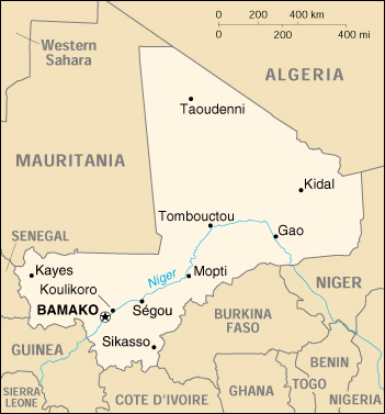
Capital: Bamako
Economic aid – recipient: $596.4 million (1995)
Geography of Mali
Location: Western Africa, southwest of Algeria
Geographic coordinates: 17 00 N, 4 00 W
Area:
total: 1.24 million sq km
land: 1.22 million sq km
water: 20,000 sq km
Land boundaries:
total: 7,243 km
border countries: Algeria 1,376 km, Burkina Faso 1,000 km, Guinea 858 km, Cote d’Ivoire 532 km, Mauritania 2,237 km, Niger 821 km, Senegal 419 km
Coastline: 0 km (landlocked)
Climate: subtropical to arid; hot and dry February to June; rainy, humid, and mild June to November; cool and dry November to February
Terrain: mostly flat to rolling northern plains covered by sand; savanna in south, rugged hills in northeast
Elevation extremes:
lowest point: Senegal River 23 m
highest point: Hombori Tondo 1,155 m
Natural resources: gold, phosphates, kaolin, salt, limestone, uranium, hydropower
note: bauxite, iron ore, manganese, tin, and copper deposits are known but not exploited
Land use:
arable land: 2%
permanent crops: 0%
permanent pastures: 25%
forests and woodland: 6%
other: 67% (1993 est.)
Irrigated land: 780 sq km (1993 est.)
Natural hazards: hot, dust-laden harmattan haze common during dry seasons; recurring droughts
Environment – current issues: deforestation; soil erosion; desertification; inadequate supplies of potable water; poaching
Environment – international agreements:
party to: Biodiversity, Climate Change, Desertification, Endangered Species, Hazardous Wastes, Law of the Sea, Ozone Layer Protection, Wetlands
signed, but not ratified: Climate Change-Kyoto Protocol, Nuclear Test Ban
Geography – note: landlocked; divided into three natural zones: the southern, cultivated Sudanese; the central, semiarid Sahelian; and the northern, arid Saharan.
People of Mali
Mali’s population consists of diverse Sub-Saharan ethnic groups, sharing similar historic, cultural, and religious traditions. Exceptions are the Tuaregs and Maurs, desert nomads, related to the North African Berbers. The Tuaregs traditionally have opposed the central government.
Historically, good inter-ethnic relations throughout the rest of the country were facilitated by easy mobility on the Niger River and across the country’s vast savannahs. Each ethnic group was traditionally tied to a specific occupation, all working within close proximity. The Bambara, Malinke, Sarakole, and Dogon are farmers; the Fulani, Maur, and Tuareg are herders; while the Bozo are fishers. In recent years, this linkage has shifted as ethnic groups seek diverse, nontraditional sources of income.
Although each ethnic group speaks a separate language, nearly 80% of Malians communicate in Bambara, the common language of the marketplace. Malians enjoy a relative harmony rare in African states.
Population: 12,291,529 (July 2005 est.)
Age structure:
0-14 years: 47.2%
15-64 years: 49.73%
65 years and over: 3.07%
Population growth rate: 2.97%
Birth rate: 48.79 births/1,000 population
Death rate: 18.71 deaths/1,000 population
Net migration rate: -0.36 migrant(s)/1,000 population
Infant mortality rate: 121.44 deaths/1,000 live births
Life expectancy at birth:
total population: 47.02 years
male: 45.84 years
female: 48.24 years
Total fertility rate: 6.81 children born/woman
Nationality:
noun: Malian(s)
adjective: Malian
Ethnic groups: Mande 50% (Bambara, Malinke, Soninke), Peul 17%, Voltaic 12%, Songhai 6%, Tuareg and Moor 10%, other 5%
Religions: Muslim 90%, indigenous beliefs 9%, Christian 1%
Languages: French (official), Bambara 80%, numerous African languages
Literacy:
definition: age 15 and over can read and write
total population: 31%
male: 39.4%
female: 23.1% (1995 est.)
History of Mali
Malians express great pride in their ancestry. Mali is the cultural heir to the succession of Ancient African empires–Ghana, Malinké, and Songhai–that occupied the West African savannah. These empires controlled Saharan trade and were in touch with Mediterranean and Middle Eastern centers of civilization.
The Ghana Empire, dominated by the Soninke people and centered in the area along the Malian-Mauritanian frontier, was a powerful trading state from about A.D. 700 to 1075. The Malinke Kingdom of Mali had its origins on the upper Niger River in the 11th century. Expanding rapidly in the 13th century under the leadership of Soundiata Keita, it reached its height about 1325, when it conquered Timbuktu and Gao. Thereafter, the kingdom began to decline, and by the 15th century, it controlled only a small fraction of its former domain.
The Songhai Empire expanded its power from its center in Gao during the period 1465-1530. At its peak under Askia Mohammad I, it encompassed the Hausa states as far as Kano (in present-day Nigeria) and much of the territory that had belonged to the Mali Empire in the west. It was destroyed by a Moroccan invasion in 1591.
French military penetration of the Soudan (the French name for the area) began around 1880. Ten years later, the French made a concerted effort to occupy the interior. The timing and resident military governors determined methods of their advances. A French civilian governor of Soudan was appointed in 1893, but resistance to French control did not end until 1898, when the Malinké warrior Samory Touré was defeated after 7 years of war. The French attempted to rule indirectly, but in many areas they disregarded traditional authorities and governed through appointed chiefs. As the colony of French Soudan, Mali was administered with other French colonial territories as the Federation of French West Africa.
In 1956, with the passing of France’s Fundamental Law (Loi Cadre), the Territorial Assembly obtained extensive powers over internal affairs and was permitted to form a cabinet with executive authority over matters within the Assembly’s competence. After the 1958 French constitutional referendum, the “Republique Soudanaise” became a member of the French Community and enjoyed complete internal autonomy.
In January 1959, Soudan joined Senegal to form the Mali Federation, which became fully independent within the French Community on June 20, 1960. The federation collapsed on August 20, 1960, when Senegal seceded. On September 22, Soudan proclaimed itself the Republic of Mali and withdrew from the French Community.
President Modibo Keita, whose party Union Soudanaise du Rassemblement DemocratiqueAfricain–US/RDA had dominated preindependence politics, moved quickly to declare a single-party state and to pursue a socialist policy based on extensive nationalization. A continuously deteriorating economy led to a decision to rejoin the Franc Zone in 1967 and modify some of the economic excesses.
On November 19, 1968, a group of young officers staged a bloodless coup and set up a 14-member Military Committee for National Liberation (CMLN), with Lt. Moussa Traore as president. The military leaders attempted to pursue economic reforms but for several years faced debilitating internal political struggles and the disastrous Sahelian drought.
A new constitution, approved in 1974, created a one-party state and was designed to move Mali toward civilian rule. However, the military leaders remained in power. In September 1976, a new political party was established, the Democratic Union of the Malian People (UDPM), based on the concept of democratic centralism. Single-party presidential and legislative elections were held in June 1979, and Gen. Moussa Traore received 99% of the votes. His efforts at consolidating the single-party government were challenged in 1980 by student-led, anti-government demonstrations, which were brutally put down, and by three coup attempts.
The political situation stabilized during 1981 and 1982 and remained generally calm throughout the 1980s. The UDPM spread its structure to Cercles and Arrondissements across the land. Shifting its attention to Mali’s economic difficulties, the government approved plans for cereal marketing liberalization, reform in the state enterprise system, new incentives to private enterprise, and worked out a new structural adjustment agreement with the International Monetary Fund (IMF).
However, by 1990, there was growing dissatisfaction with the demands for austerity imposed by the IMF’s economic reform programs and the perception that the president and his close associates were not themselves adhering to those demands.
As in other African countries, demands for multi-party democracy increased. The Traore government allowed some opening of the system, including the establishment of an independent press and independent political associations, but insisted that Mali was not ready for democracy. In early 1991, student-led, anti-government rioting broke out again, but this time government workers and others supported it. On March 26, 1991, after 4 days of intense anti-government rioting, a group of 17 military officers arrested President Traore and suspended the constitution. Within days, these officers joined with the Coordinating Committee of Democratic Associations to form a predominantly civilian, 25-member ruling body, the Transitional Committee for the Salvation of the People (CTSP). The CTSP then appointed a civilian-led government. A national conference held in August 1991 produced a draft constitution (approved in a referendum January 12, 1992), a charter for political parties, and an electoral code. Political parties were allowed to form freely. Between January and April 1992, a president, National Assembly, and municipal councils were elected. On June 8, 1992, Alpha Oumar Konare, the candidate of the Association for Democracy in Mali (ADEMA), was inaugurated as the president of Mali’s Third Republic.
In 1997, attempts to renew national institutions through democratic elections ran into administrative difficulties, resulting in a court-ordered annulment of the legislative elections held in April 1997. The exercise, nonetheless, demonstrated the overwhelming strength of President Konare’s ADEMA party, causing some other historic parties to boycott subsequent elections. President Konare won the presidential election against scant opposition on May 11. In the two-round legislative elections conducted on July 21 and August 3, ADEMA secured more than 80% of the National Assembly seats.
General elections are scheduled to take place in 2002. President Konare will not seek reelection since he is serving his second and last term as required by the constitution. All political parties have pledged to participate in the upcoming elections. The government is in the process of completing a new voter’s list after a general census was administered a few months ago with the support of all political parties.
Mali Economy
Economy – overview: Mali is among the poorest countries in the world, with 65% of its land area desert or semidesert. Economic activity is largely confined to the riverine area irrigated by the Niger. About 10% of the population is nomadic and some 80% of the labor force is engaged in farming and fishing. Industrial activity is concentrated on processing farm commodities. Mali is heavily dependent on foreign aid and vulnerable to fluctuations in world prices for cotton, its main export. In 1997, the government continued its successful implementation of an IMF-recommended structural adjustment program that is helping the economy grow, diversify, and attract foreign investment. Mali’s adherence to economic reform and the 50% devaluation of the African franc in January 1994 have pushed up economic growth to a sturdy 5% average in 1996-2000. Growth should remain around 5% in 2001-02, and inflation should stay less than 2%.
GDP: purchasing power parity – $9.1 billion (2000 est.)
GDP – real growth rate: 4.8% (2000 est.)
GDP – per capita: purchasing power parity – $850 (2000 est.)
GDP – composition by sector:
agriculture: 46%
industry: 21%
services: 33% (1998)
Household income or consumption by percentage share:
lowest 10%: 1.8%
highest 10%: 40.4%
Inflation rate (consumer prices): 0.8% (2000 est.)
Labor force – by occupation: agriculture and fishing 80% (1998 est.)
Budget:
revenues: $730 million
expenditures: $770 million, including capital expenditures of $320 million (1997 est.)
Industries: minor local consumer goods production and food processing; construction; phosphate and gold mining
Industrial production growth rate: 0.6% (1995 est.)
Electricity – production: 445 million kWh (1999)
Electricity – production by source:
fossil fuel: 44.94%
hydro: 55.06%
nuclear: 0%
other: 0% (1999)
Electricity – consumption: 413.9 million kWh (1999)
Agriculture – products: cotton, millet, rice, corn, vegetables, peanuts; cattle, sheep, goats
Exports: $480 million (f.o.b., 2000 est.)
Exports – commodities: cotton 50%, gold, livestock (1999 est.)
Exports – partners: Italy 18%, Thailand 15%, Germany 7%, Portugal 4% (1999)
Imports: $575 million (f.o.b., 2000 est.)
Imports – commodities: machinery and equipment, construction materials, petroleum, foodstuffs, textiles
Imports – partners: Cote d’Ivoire 19%, France 19%, Senegal 4%, Benelux 3% (1999)
Debt – external: $3 billion (1999)
Economic aid – recipient: $596.4 million (1995)
Currency: Communaute Financiere Africaine franc (XOF); note – responsible authority is the Central Bank of the West African States
Map of Mali