Background: In 1865, Britain and Bhutan signed the Treaty of Sinchulu, under which Bhutan would receive an annual subsidy in exchange for ceding some border land. Under British influence, a monarchy was set up in 1907; three years later, a treaty was signed whereby the British agreed not to interfere in Bhutanese internal affairs and Bhutan allowed Britain to direct its foreign affairs. This role was assumed by independent India after 1947. Two years later, a formal Indo-Bhutanese accord returned the areas of Bhutan annexed by the British, formalized the annual subsidies the country received, and defined India’s responsibilities in defense and foreign relations. A refugee issue of some 100,000 Bhutanese in Nepal remains unresolved; 90% of these displaced persons are housed in seven United Nations Office of the High Commissioner for Refugees (UNHCR) camps. Maoist Assamese separatists from India, who have established themselves in the southeast portion of Bhutan, have drawn Indian cross-border incursions.
Government type: monarchy; special treaty relationship with India
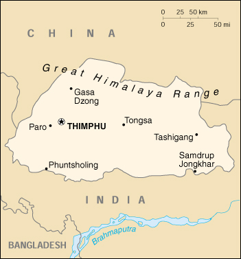
Capital: Thimphu
Currency: 1 ngultrum (Nu) = 100 chetrum; note – Indian currency is also legal tender
Geography of Bhutan
Location: Southern Asia, between China and India
Geographic coordinates: 27 30 N, 90 30 E
Map references: Asia
Area:
total: 47,000 sq. km
land: 47,000 sq. km
water: 0 sq. km
Land boundaries:
total: 1,075 km
border countries: China 470 km, India 605 km
Coastline: 0 km (landlocked)
Climate: varies; tropical in southern plains; cool winters and hot summers in central valleys; severe winters and cool summers in Himalayas
Terrain: mostly mountainous with some fertile valleys and savanna
Elevation extremes:
lowest point: Drangme Chhu 97 m
highest point: Kula Kangri 7,553 m
Natural resources: timber, hydropower, gypsum, calcium carbide
Land use:
arable land: 2%
permanent crops: 0%
permanent pastures: 6%
forests and woodland: 66%
other: 26% (1993 est.)
Irrigated land: 340 sq km (1993 est.)
Natural hazards: violent storms coming down from the Himalayas are the source of the country’s name which translates as Land of the Thunder Dragon; frequent landslides during the rainy season
Environment – current issues: soil erosion; limited access to potable water
Environment – international agreements:
party to: Biodiversity, Climate Change, Nuclear Test Ban
signed, but not ratified: Law of the Sea
Geography – note: landlocked; strategic location between China and India; controls several key Himalayan mountain passes
People of Bhutan
The Land
Landlocked Bhutan is situated in the eastern Himalayas and is mostly mountainous and heavily forested. It is bordered for 470 kilometers by Tibet (China’s Xizang Autonomous Region) to the north and northwest and for 605 kilometers by India’s states of Sikkim to the west, West Bengal to the southwest, Assam to the south and southeast, and Arunachal Pradesh (formerly the North-East Frontier Agency) to the east. Sikkim, an eighty-eight-kilometer-wide territory, divides Bhutan from Nepal, while West Bengal separates Bhutan from Bangladesh by only sixty kilometers. At its longest east-west dimension, Bhutan stretches around 300 kilometers; it measures 170 kilometers at its maximum north-south dimension, forming a total of 46,500 square kilometers, an area one-third the size of Nepal. In the mid-1980s, about 70 percent of Bhutan was covered with forests; 10 percent was covered with year-round snow and glaciers; nearly 6 percent was permanently cultivated or used for human habitation; another 3 percent was used for shifting cultivation (tsheri), a practice banned by the government; and 5 percent was used as meadows and pastures. The rest of the land was either barren rocky areas or scrubland.
Early British visitors to Bhutan reported “dark and steep glens, and the high tops of mountains lost in the clouds, constitut[ing] altogether a scene of extraordinary magnificence and sublimity.” One of the most rugged mountain terrains in the world, it has elevations ranging from 160 meters to more than 7,000 meters above sea level, in some cases within distances of less than 100 kilometers of each other. Bhutan’s highest peak, at 7,554 meters above sea level, is north-central Kulha Gangri, close to the border with China; the second highest peak, Chomo Lhari, overlooking the Chumbi Valley in the west, is 7,314 meters above sea level; nineteen other peaks exceed 7,000 meters.
In the north, the snowcapped Great Himalayan Range reaches heights of over 7,500 meters above sea level and extends along the Bhutan-China border. The northern region consists of an arc of glaciated mountain peaks with an arctic climate at the highest elevations. Watered by snow-fed rivers, alpine valleys in this region provide pasturage for livestock tended by a sparse population of migratory shepherds.
The Inner Himalayas are southward spurs of the Great Himayalan Range. The Black Mountains, in central Bhutan, form a watershed between two major river systems, the Mo Chhu and the Drangme Chhu (chhu means river). Peaks in the Black Mountains range between 1,500 meters and 2,700 meters above sea level, and the fast-flowing rivers have carved out spectacular gorges in the lower mountain areas. The woodlands of the central region provide most of Bhutan’s valuable forest production. Eastern Bhutan is divided by another southward spur, the Donga Range. Western Bhutan has fertile, cultivated valleys and terraced river basins.
In the south, the Southern Hills, or Siwalik Hills, the foothills of the Himalayas, are covered with dense deciduous forest, alluvial lowland river valleys, and mountains that reach to around 1,500 meters above sea level. The foothills descend into the subtropical Duars Plain. Most of the Duars Plain proper is located in India, and ten to fifteen kilometers penetrate inside Bhutan. The Bhutan Duars has two parts. The northern Duars, which abuts the Himalayan foothills, has rugged, slopping terrain and dry porous soil with dense vegetation and abundant wildlife. The southern Duars has moderately fertile soil, heavy savanna grass, dense mixed jungle, and freshwater springs. Taken as a whole, the Duars provides the greatest amount of fertile flatlands in Bhutan. Rice and other crops are grown on the plains and mountainsides up to 1,200 meters. Bhutan’s most important commercial centers– Phuntsholing, Geylegphug, and Samdrup Jongkhar–are located in the Duars, reflecting the meaning of the name, which is derived from the Hindi dwar and means gateway. Rhinoceros, tigers, leopards, elephants, and other wildlife inhabit the region.
Climate
Bhutan’s climate is as varied as its altitudes and, like most of Asia, is affected by monsoons. Western Bhutan is particularly affected by monsoons that bring between 60 and 90 percent of the region’s rainfall. The climate is humid and subtropical in the southern plains and foothills, temperate in the inner Himalayan valleys of the southern and central regions, and cold in the north, with year-round snow on the main Himalayan summits.
Temperatures vary according to elevation. Temperatures in Thimphu, located at 2,200 meters above sea level in west-central Bhutan, range from approximately 15° C to 26° C during the monsoon season of June through September but drop to between about -4° C and 16° C in January. Most of the central portion of the country experiences a cool, temperate climate yearround . In the south, a hot, humid climate helps maintain a fairly even temperature range of between 15° C and 30° C year-round, although temperatures sometimes reach 40° C in the valleys during the summer.
Annual precipitation ranges widely in various parts of the country. In the severe climate of the north, there is only about forty millimeters of annual precipitation–primarily snow. In the temperate central regions, a yearly average of around 1,000 millimeters is more common, and 7,800 millimeters per year has been registered at some locations in the humid, subtropical south, ensuring the thick tropical forest, or savanna. Thimphu experiences dry winter months (December through February) and almost no precipitation until March, when rainfall averages 20 millimeters a month and increases steadily thereafter to a high of 220 millimeters in August for a total annual rainfall of nearly 650 millimeters.
Bhutan’s generally dry spring starts in early March and lasts until mid-April. Summer weather commences in mid-April with occasional showers and continues through the premonsoon rains of late June. The summer monsoon lasts from late June through late September with heavy rains from the southwest. The monsoon weather, blocked from its northward progress by the Himalayas, brings heavy rains, high humidity, flash floods and landslides, and numerous misty, overcast days. Autumn, from late September or early October to late November, follows the rainy season. It is characterized by bright, sunny days and some early snowfalls at higher elevations. From late November until March, winter sets in, with frost throughout much of the country and snowfall common above elevations of 3,000 meters. The winter northeast monsoon brings gale-force winds down through high mountain passes, giving Bhutan its name– Drukyul, which in the Dzongkha language mean Land of the Thunder Dragon.
River Systems
Bhutan has four major river systems: the Drangme Chhu; the Puna Tsang Chhu, also called the Sankosh; the Wang Chhu; and the Amo Chhu. Each flows swiftly out of the Himalayas, southerly through the Duars to join the Brahmaputra River in India, and thence through Bangladesh where the Brahmaputra (or Jamuna in Bangladesh) joins the mighty Ganges (or Padma in Bangladesh) to flow into the Bay of Bengal. The largest river system, the Drangme Chhu, flows southwesterly from India’s state of Arunachal Pradesh and has three major branches: the Drangme Chhu, Mangde Chhu, and Bumthang Chhu. These branches form the Drangme Chhu basin, which spreads over most of eastern Bhutan and drains the Tongsa and Bumthang valleys. In the Duars, where eight tributaries join it, the Drangme Chhu is called the Manas Chhu. The 320-kilometer-long Puna Tsang Chhu rises in northwestern Bhutan as the Mo Chhu and Pho Chhu, which are fed by the snows from the Great Himalayan Range. They flow southerly to Punakha, where they join to form the Puna Tsang Chhu, which flows southerly into India’s state of West Bengal. The tributaries of the 370-kilometer-long Wang Chhu rise in Tibet. The Wang Chhu itself flows southeasterly through west-central Bhutan, drains the Ha, Paro, and Thimphu valleys, and continues into the Duars, where it enters West Bengal as the Raigye Chhu. The smallest river system, the Torsa Chhu, known as the Amo Chhu in its northern reaches, also flows out of Tibet into the Chumbi Valley and swiftly through western Bhutan before broadening near Phuntsholing and then flowing into India.
Glaciers
Glaciers in northern Bhutan, which cover about 10 percent of the total surface area, are an important renewable source of water for Bhutan’s rivers. Fed by fresh snow each winter and slow melting in the summer, the glaciers bring millions of liters of fresh water to Bhutan and downriver areas each year. Glacial melt added to monsoon-swollen rivers, however, also contributes to flooding and potential disaster.
History of Bhutan
THE HIMALAYAN KINGDOMS of Nepal and Bhutan share a history of influence by Tibet, China, and India, and an interlude of British colonial guidance. Although the kingdoms are not contiguous, each country is bordered by China to the north and India on its other peripheries. Both kingdoms are ruled by hereditary monarchs and are traditional societies with predominantly agricultural economies; their cultures, however, differ. Nepal’s Hinduism, a legacy of India’s influence, defines its culture and caste-structured society. Bhutan’s Buddhist practices and culture reflect India’s influence by way of Tibet. The two countries’ legal systems also reflect their heritage. Nepal’s judicial system blends Hindu legal and English common law traditions. Bhutan’s legal system is based on Buddhist law and English common law.
Bhutan has its own distinct history, although it shares Nepal’s Himalayan geography and neighbors. Only one-third the size of Nepal, Bhutan also has a much smaller population: estimated at about 600,000 persons in 1990 as compared to a population of over 19 million in Nepal.
The precursor of Bhutan, the state of Lhomon or Monyul, was said to have existed between 500 B.C. and 600 A.D. At the end of that period, Buddhism was introduced into the country; a branch of Mahayana Buddhism is the state religion of Bhutan. Bhutan was subject to both Indian and Tibetan influences, and small independent monarchies began to develop in the country by the early ninth century. Religious rivalry among various Buddhist subsects also influenced political development; the rivalry began in the tenth century and continued through the seventeenth century, when a theocratic government independent of Tibetan political influence united the country. From that time until 1907, the Kingdom of Bhutan, or Drukyul (literally land of the Thunder Dragon), had a dual system of shared civil and spiritual (Buddhist) rule. In 1907 the absolute monarchy was established, and the hereditary position of Druk Gyalpo, or Dragon King, was awarded to the powerful Wangchuck family. Since 1972, Jigme Singye Wangchuck has held the position of Druk Gyalpo.
The Druk Gyalpo controls the executive, legislative, and judicial branches of the government. The monarchy is absolute, but the king is admired and respected and is referred to by the people as “our King.” The Council of Ministers and Royal Advisory Council are part of the executive branch of government. The legislative branch is made up of the unicameral National Assembly, or Tshogdu, whose members are either indirectly elected or appointed by the Druk Gyalpo. Bhutan has neither a written constitution nor organic laws. The 1953 royal decree on the Constitution of the National Assembly is the primary legal, or constitutional, basis for that body and sets forth its rules and procedures. The Supreme Court of Appeal, in effect the Druk Gyalpo, is the highest level court; judges are appointed by the Druk Gyalpo. There are no lawyers. The civil code and criminal code are based on seventeenth-century concepts.
Under Jigme Singye Wangchuck, Bhutan’s centrally controlled government system has been instrumental in initiating greater political participation. In the early 1990s, however, there were still no legal political parties–although there were elite political factions–and no national elections. There was no overt communist presence. Each family was allowed one vote in village- level elections. Local government was divided into zones, districts, subdistricts, and village groups, and meetings were regularly held at the village and block (gewog) levels, where issues were decided by public debate. The complex administrative network of consultation and decisionmaking by consensus obscured the need for national elections. At the 1992 session of the National Assembly, support for the hereditary monarchy was unanimously reaffirmed.
Bhutan has a diverse population. It is home to four ethnic groups: Ngalop–of Tibetan origin; Sharchop–of Indo- Mongoloid origin; aboriginal, or indigenous, tribal peoples; and Nepalese. In the early 1990s, the first three groups made up about 72 percent of the population. According to this estimate, the Nepalese comprised approximately 28 percent of the population; other estimates suggested that 30 to 40 percent might be Nepalese. The Nepalese constituted a majority in southern Bhutan, where, in an effort to maintain traditional culture and control, the government has tried to confine their immigration and restrict their residence and employment. In the early 1990s, only approximately 15 percent of the Nepalese in Bhutan were considered legal permanent residents; only those immigrants who had resided in Bhutan for fifteen or twenty years–the number of years depended on their occupational status and other criteria–were considered for citizenship. Nepalese immigrants who were asked to leave because their claims to citizenship did not conform to the 1985 Citizenship Act openly voiced their discontent with the government. Illegal immigrants often were militant antinationals.
In the 1980s, the Bhutanese, believing their identity threatened by absorption of a growing Nepalese minority and the specter of annexation by India, promulgated a policy of driglam namzha, “national customs and etiquette.” This policy, sought to preserve and enhance Bhutanese cultural identity and bolster Bhutanese nationalism. The policy mandated the wearing of national dress for formal occasions and the use of the official language, Dzongkha, in schools. In 1989, it was decreed that Nepali, which had been offered as an optional language, was no longer to be taught in the schools. Subsequent government decrees contributed to a growing conflict with ethnic Nepalese, who sought to maintain their own identity and viewed these edicts as restrictive. Ethnic strife increased as the aftereffects of Nepal’s prodemocracy movement spread to Bhutan, where Nepalese communities demonstrated against the government in an effort to protect their rights from the driglam namzha policy. Expatriate Nepalese political groups in Nepal and India supported these antigovernment activities, further alienating the Bhutanese.
Bhutan’s military force, the Royal Bhutan Army, is very small; in 1990 it numbered only 6,000 persons. The Druk Gyalpo is the supreme commander of the army, but daily operations are the responsibility of the chief operations officer. The army’s primary mission is border defense although it also assists the Royal Bhutan Police in internal security matters.
Bhutan is considered a least-developed country. Its work force is largely unskilled, and a wide gap exists between the rich and the poor. Farming is the mainstay of the economy and accounts for most of the gross domestic product. Although Bhutan did not begin to establish its industrial base until the 1950s, careful economic planning and use of foreign aid have resulted in measurable improvements in economic efficiency and performance over the last four decades. As is the case in Nepal, tourists bring in a major portion of the country’s foreign exchange.
Social status in Bhutan depends primarily on economic standing in the community. Specifically, it depends on landownership, occupation, and perceived religious authority. The society is male dominated. Although as of 1992 the government officially encouraged increased participation of women in political and administrative life, women remained in a secondary position, particularly in business and the civil service. Bhutanese women, however, do have a dominant social position, and land often passes to daughters, not to sons. Bhutan’s traditional society is both matriarchal and patriarchal; the head of the family is the member in highest esteem. However, men predominate in government and have more opportunities for higher education than do women.
As of 1992, education in Bhutan is free for eleven years but not compulsory. Men have literacy rates about three times higher than those for women, and school enrollment levels are higher for males. As is the case in Nepal, social services are not widespread. Modern medical care is lacking, as is clean drinking water and adequate sanitation. Not surprisingly, gastrointestinal diseases are widespread. Nutrional deficiencies are also prevalent; serious malnutrition, however, does not appear to be a problem. Like Nepal, the country had high morbidity and death rates in the early 1990s.
Foreign aid, grants, and concessionary loans constituted a large percentage of Bhutan’s budget in the early 1990s. Like Nepal, Bhutan received foreign assistance from the United Nations, the Colombo Plan, the Asian Development Bank, the World Bank, and the Organization of Petroleum Exporting Countries, as well as official development assistance and other official flows. Because Bhutan had no formal diplomatic relations with the United States as of 1992, no official aid was forthcoming from Washington.
Bhutan’s foreign policy has been affected by its geostrategic location. From the seventh century until 1860, the country’s foreign policy was influenced by Tibet; next followed a period of British guidance over foreign affairs. After India received independence from the United Kingdom in 1947, Bhutan came under India’s influence. Thimphu and New Delhi’s relationship is governed by the 1949 Treaty of Friendship between the Government of India and the Government of Bhutan–in force in perpetuity–which calls for peace and noninterference in internal affairs and New Delhi’s guidance and advice in external relations. Like Nepal, however, Bhutan is exhibiting greater independence in its foreign policy, and by the early 1990s was, in effect, autonomous in its foreign relations. Thimphu has established bilateral diplomatic relations with other countries and has joined various multilateral and regional organizations. Bhutan belongs to the United Nations, as well as to organizations such as SAARC, the Nonaligned Movement, and the Asian Development Bank. It does not accept compulsory United Nations International Court of Justice jurisdiction.
Both Nepal and Bhutan were facing refugee problems in the early 1990s; statistics on the number of refugees come from diverse sources and are discrepant. In April 1992, the United Nations High Commissioner for Refugees estimated that since 1986 more than 30,000 ethnic Nepalese had left Bhutan because of political discontent, poor employment prospects, or because they were considered illegal immigrants. A much higher figure is projected by G.P. Koirala, Nepal’s prime minister, who has estimated that in the early 1990s Nepalese from Bhutan seeking to escape the sanctions imposed by driglam namzha arrived in Nepal at the rate of 200 persons daily.
Antinationals in Bhutan used the growing number of southern Bhutanese-Nepalese in the refugee camps within Nepal as a means to publicize and internationalize their plight. To this end, they encouraged Nepalese to leave Bhutan and also encouraged Nepalese from India to enter the camps. For Bhutan, the departure of the Nepalese often meant the loss of skilled laborers; however, it also resulted in the exodus of unwanted agitators. For Nepal, the refugees were an added economic burden–more people needing housing, food, clothing, education, and other social services. Living conditions in the refugee camps within Nepal were reported to be poor. As of mid-1992, the camps were filled with people holding Nepalese citizenship cards, Bhutanese citizenship cards, and UNHCR certificates attesting they were “Bhutanese refugees.” However, because each party seeks to present its own case, all statistics and statements related to the Nepalese refugee situation must be viewed cautiously.
The refugee problem presented a challenge to India, which needed to balance its interests in maintaining Bhutan’s stability with the necessity of not inflaming nationalist passions among its own ethnic Nepalese population and not upsetting its relations with either Nepal or Bhutan. India would not allow its territory to be used as a staging ground for protests by Bhutanese residents of Nepalese origin. The situation was further complicated by the fact that Indian laborers who entered Nepal in search of work displaced underemployed and unemployed Nepalese workers.
Bhutan Economy
Economy – overview: The economy, one of the world’s smallest and least developed, is based on agriculture and forestry, which provide the main livelihood for more than 90% of the population. Agriculture consists largely of subsistence farming and animal husbandry. Rugged mountains dominate the terrain and make the building of roads and other infrastructure difficult and expensive. The economy is closely aligned with India’s through strong trade and monetary links. The industrial sector is technologically backward, with most production of the cottage industry type. Most development projects, such as road construction, rely on Indian migrant labor. Bhutan’s hydropower potential and its attraction for tourists are key resources. The Bhutanese Government has made some progress in expanding the nation’s productive base and improving social welfare. Model education, social, and environment programs in Bhutan are underway with support from multilateral development organizations. Each economic program takes into account the government’s desire to protect the country’s environment and cultural traditions. Detailed controls and uncertain policies in areas like industrial licensing, trade, labor, and finance continue to hamper foreign investment.
GDP: purchasing power parity – $2.3 billion (2000 est.)
GDP – real growth rate: 6% (2000 est.)
GDP – per capita: purchasing power parity – $1,100 (2000 est.)
GDP – composition by sector:
agriculture: 38%
industry: 37%
services: 25% (2000 est.)
Inflation rate (consumer prices): 7% (2000 est.)
Labor force – by occupation: agriculture 93%, services 5%, industry and commerce 2%
Budget:
revenues: $146 million
expenditures: $152 million (FY95/96 est.)
note: the government of India finances nearly three-fifths of Bhutan’s budget expenditures
Industries: cement, wood products, processed fruits, alcoholic beverages, calcium carbide
Industrial production growth rate: 9.3% (1996 est.)
Electricity – production: 1.856 billion kWh (1999)
Electricity – production by source:
fossil fuel: 0.05%
hydro: 99.95%
nuclear: 0%
other: 0% (1999)
Electricity – consumption: 191.1 million kWh (1999)
Electricity – exports: 1.55 billion kWh (1999)
Electricity – imports: 15 million kWh (1999)
Agriculture – products: rice, corn, root crops, citrus, food grains; dairy products, eggs
Exports: $154 million (f.o.b., 2000 est.)
Exports – commodities: cardamom, gypsum, timber, handicrafts, cement, fruit, electricity (to India), precious stones, spices
Exports – partners: India 94%, Bangladesh
Imports: $269 million (c.i.f., 2000 est.)
Imports – commodities: fuel and lubricants, grain, machinery and parts, vehicles, fabrics, rice
Imports – partners: India 77%, Japan, UK, Germany, US
Debt – external: $120 million (1998)
Economic aid – recipient: $73.8 million (1995)
Currency: 1 ngultrum (Nu) = 100 chetrum; note – Indian currency is also legal tender
Map of Bhutan