Mexico’s pyramids date back to pre-Columbian times. Some were built by the ancient Maya and Aztec civilizations between 200–1,500 CE, while others date back to the Olmec people who lived between 1,200–400 BCE.
The pyramids are scattered throughout Mexico like confetti at a fiesta. You can locate them in places like Teotihuacan, Chichen Itza, Palenque, Tikal, Calakmul, Monte Albán, Tulum, El Tajín, Coba, and Uxmal.
In the chapters to follow, we’ll go on a tour across each region that houses these historic treasures, uncovering their tales, significance, and the profound legacy they have left behind.
Let’s meet the pyramids of Mexico.
Pyramids in Teotihuacan
Teotihuacan is an ancient city close to what is now Mexico City and its name translates to “the place where the gods were created.”
The founders of Teotihuacan left no written documents about its construction, and the people who created it, as well as their culture, are still largely unknown. The metropolis, however, had a tremendous impact on the Mayans and the Aztecs.
Teotihuacan has three primary pyramids: the Pyramid of the Sun, the Pyramid of the Moon, and the Temple of the Feathered Serpent.
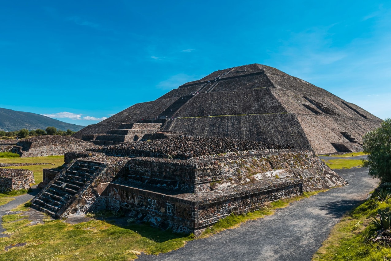
Pyramid of the Sun
The Pyramid of the Sun is the largest in Teotihuacan, completed in 200 A.D. and originally standing 206 feet tall (63 meters) on a 2,314 square feet base (215 square meters).
According to 16th-century sources, this pyramid may have been built as a temple of the sun. However, a recent study has revealed that the god worshiped in this pyramid was Tlaloc, the water deity.
Pyramid of the Moon
The Pyramid of the Moon is the oldest in Teotihuacan, constructed between 100 and 450 AD. It’s approximately 141 feet high (42 meters), with a base measuring 482 feet (147 meters) west to east and 426 feet (130 meters) north to south.
The Pyramid was likely built in honor of the Great Goddess of Teotihuacan and served as a site for human and animal sacrifices. Scientists unearthed evidence of such a ritual and found a man’s skeleton surrounded by more than 150 offerings, including knives, pyrite mirrors, hawks, and two jaguars.
Temple of the Feathered Serpent (Quetzalcoatl)
The Temple of the Feathered Serpent is thought to have been constructed around 150 AD. It measures 90 feet tall (30 meters), and its base is 180 feet wide (55 meters).
The pyramid has distinctive carved heads on its eastern side, which represent the Aztec creator god, Quetzalcoatl. The Temple of the Feathered Serpent shows a significant link with the Sacred Calendar, as more than 200 sacrifice victims were discovered inside, each representing one of the 260 days of the calendar.
Pyramids in Chichen Itza, Yucatan
Chichen Itza is located in Mexico’s Yucatan Peninsula, in what is now the state of Yucatan. It was a prominent Maya urban center and is now one of Mexico’s most well-known and well-preserved archaeological sites.
The name derives from the Maya phrases “Chi” (mouth), “Chen” (well), and “Itza” (Itza people) and means”At the mouth of the well of the Itza.”
Chichen Itza is home to two great pyramids: the Pyramid of Kukulcan (El Castillo) and the Temple of Warriors.
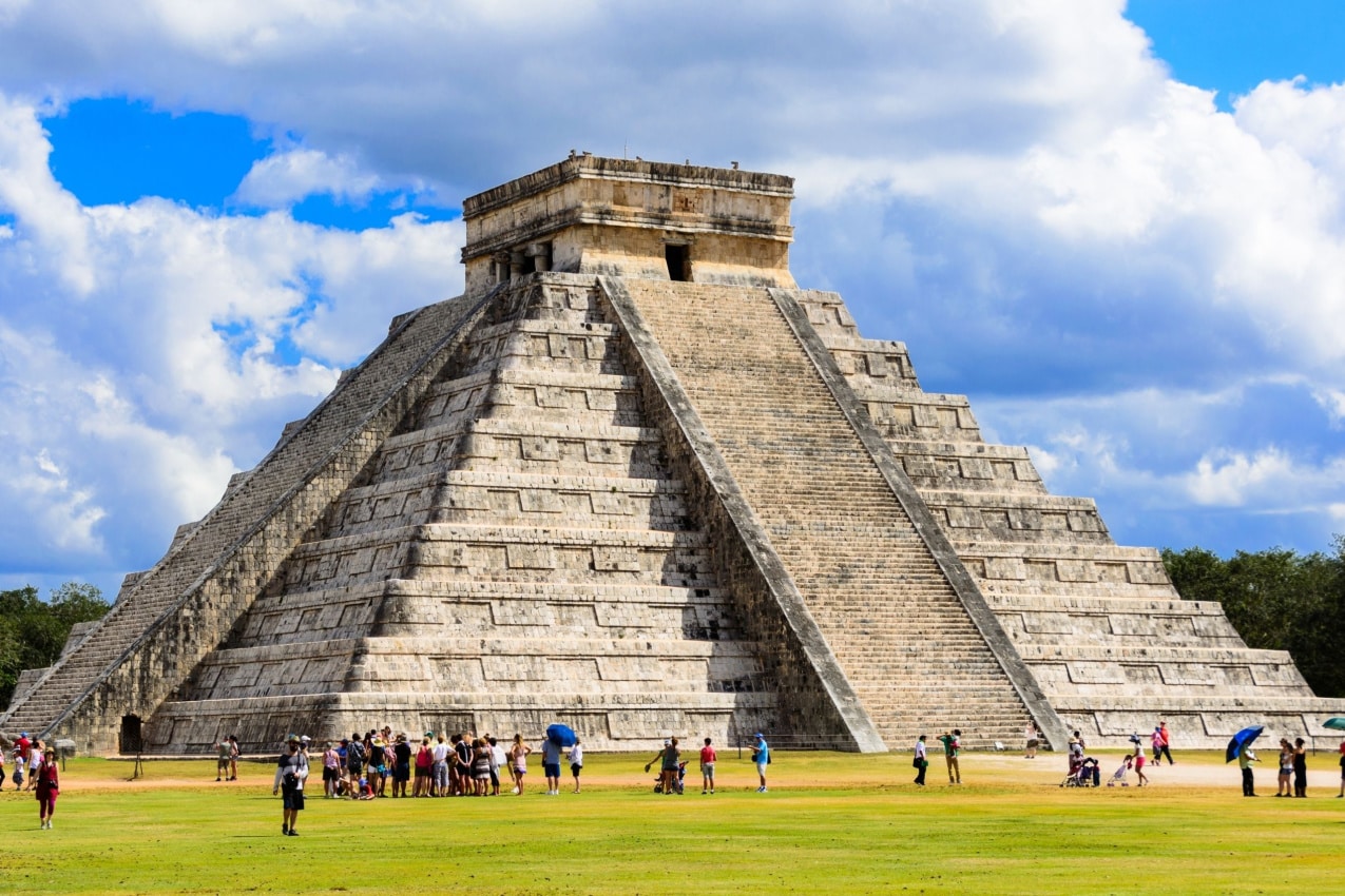
Pyramid of Kukulcan (El Castillo)
The Pyramid of Kukulcan (El Castillo) is thought to have been built around 960 AD. It has a height of around 78 feet (24 meters) and a base of about 180 feet per side (55 meters).
One of the pyramid’s most notable aspects is its alignment with celestial events, particularly the equinoxes. During these times of the year, the pyramid’s shadows create the image of a serpent writhing down its stairs. This optical phenomenon is associated with the Aztec god Kukulcan, a feathered serpent related to the Quetzalcoatl deity we mentioned before.
Temple of Warriors
The Temple of Warriors is thought to have been built between 950 – 1200 AD. This temple is 40 feet high (12 meters) and 133 feet wide (40 meters).
The temple is adorned with carved columns depicting warriors, emphasizing the importance of battle and fighting skills in Maya society. While interpretations differ, it is likely that the temple was involved in ceremonies, rituals, and events related to military and societal power dynamics.
Pyramids in Palenque, Chiapas
Palenque is an ancient city located in the tropical jungles of Chiapas that evolved around the Classic period of Maya civilization, between 250 and 600 CE.
The city was known as “Lakamha” in the Itza language, meaning “Big Water,” and houses some of the most beautiful buildings made by the Maya. All of the sites have pyramid-like shapes, although they are not full-fledged pyramids like the ones seen in Teotihuacan or Chichen Itza.
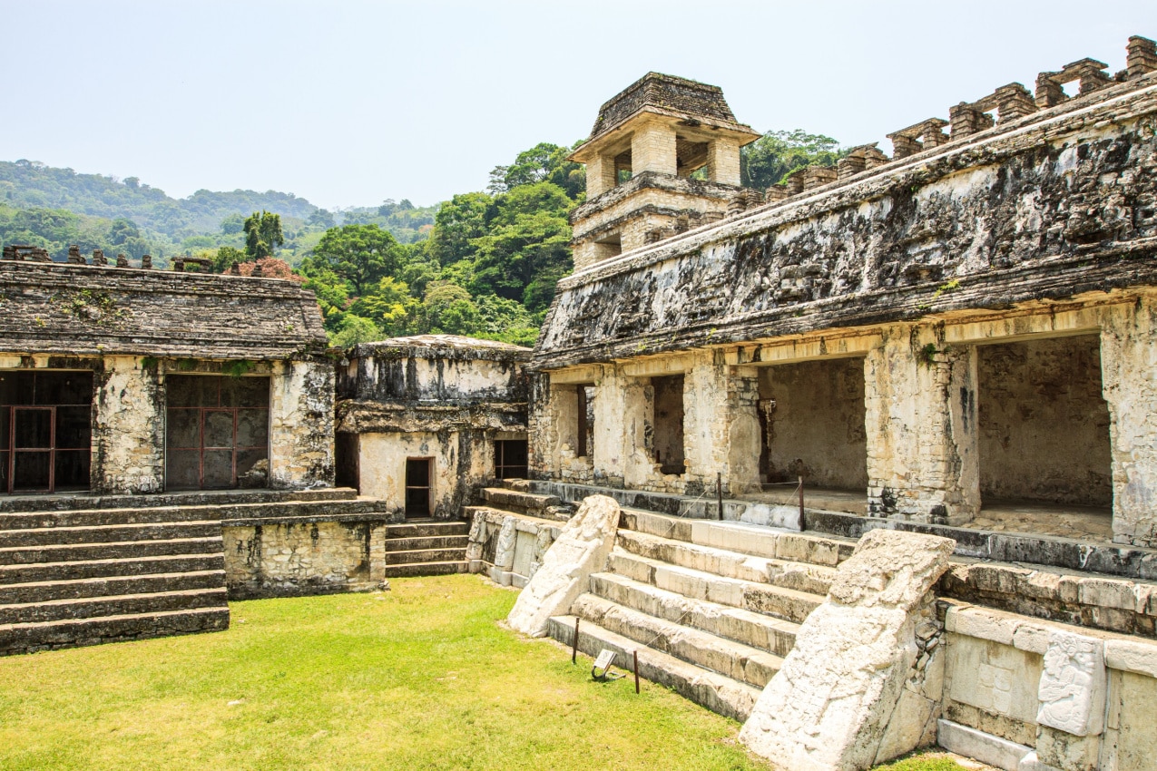
Some of the most famous sites in this ancient city include the Palace, the Temple of the Skull, Temple XIII, the Temple of the Count, the Temples of the Cross, and the most notable pyramid-like site that we’re going to talk about next — the Temple of the Inscriptions.
The Temple of the Inscriptions
The Temple of the Inscriptions is thought to have been built in 682 CE. It stands approximately 196 feet wide (60 meters) and 88 feet high (27.2 meters).
This temple is famous for its hieroglyphic inscriptions and its connection to Pakal the Great, who ruled Palenque from 603 to 683 CE.
The inside chamber of the structure is adorned with a series of nine long hieroglyphic writings. These inscriptions contain essential information about Palenque monarchs’ genealogy, achievements, and ceremonies, making them one of the most important records of Maya history.
Pyramids in Calakmul, Campeche
Calakmul is an archeological site located deep within the Calakmul Biosphere Reserve in the state of Campeche. It is thought to have been built between 250 and 900 AD during the Classic period of Mayan civilization.
The name “Calakmul” is thought to be a mixture of three Mayan words: “ca” for “two,” “lak” for “adjacent” or “adjacent to,” and “mul” for “pyramid” — roughly translating to “Two Adjacent Pyramids.”
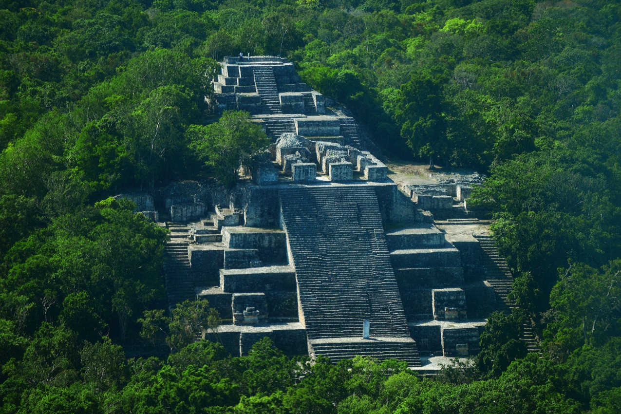
This term most likely refers to the two major pyramidal constructions at the Calakmul archaeological site — Structure II and Structure VII.
Structure II
Structure II is located in Calakmul’s main plaza and serves as a prominent focal point. It’s estimated to be 45 meters tall (148 feet), with a base of roughly 110 meters (361 feet) by 80 meters (262 feet).
Once you start climbing it, you’ll discover the pyramid’s magnificent carvings depicting past rulers, historical events, and mythical symbols, indicating that this pyramid may have served as a focal point for Calakmul’s spiritual, religious, and political activity.
Structure VII
Structure VII is found in the Great Acropolis of Calakmul, another important section of the site. Structure VII is smaller than Structure II, with an estimated height of 25 meters (82 feet) and a length of 70 meters (230 feet).
Structure VII’s significance in the overall plan of Calakmul is less documented than Structure II’s, but the pyramid is similarly covered with carvings and writings relating to the city’s traditions and beliefs.
Pyramids in Monte Albán, Oaxaca
Monte Albán is one of the most significant and famous sites of the Zapotec civilization, which flourished in the Oaxacan region from roughly 500 BC to 800 AD.
The ancient city is positioned on a big, flattened hilltop with grand vistas of the surrounding lowlands and mountains.
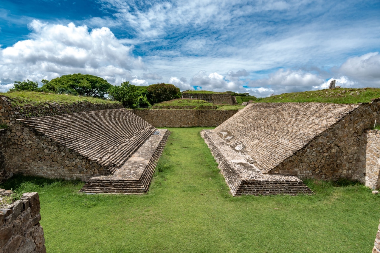
The Grand Plaza is the city’s principal architectural complex, surrounded by gigantic monuments, temples, and ball courts, with the Great Pyramid (Building J) and the South Platform being two of the most notable landmarks.
The Great Pyramid (Building J)
The Great Pyramid is located at the northernmost point of the Grand Plaza.
Its current state is the product of numerous expansions and changes. While symmetry is the dominating style on the Plaza, this building is off-axis with an unusual shape and sits atop a five-sided pyramidal base.
Within the pyramid’s walls, there are more than 40 carved slabs displaying the names of locations most likely claimed by the Monte Albán monarchs.
The main staircase of the pyramid rises to a platform at the top where religious events may have taken place. The pyramid’s placement is believed to have astronomical significance as well, as it is aligned with the bright star Capella.
The South Platform
The South Platform is located on the highest point in Monte Alban, indicating that it was most likely where the elite sat or it served as the main place for ceremonies and rituals.
While not a typical pyramid, the South Platform is a rectangular site with numerous floors and terraces. This temple is distinguished by its mosaics, which depict prominent mythological and religious figures such as gods, legendary creatures, and possibly monarchs.
Pyramids in Tulum
The ancient city of Tulum is near to the eponymous modern city and was one of the last cities constructed by the Mayas.
The ancient city flourished approximately around 1200 AD and is spectacularly positioned on a cliff overlooking the blue waters of the Caribbean Sea.
The city’s original name was believed to be Zamá, which translates to “Place of the Dawning Sun.”
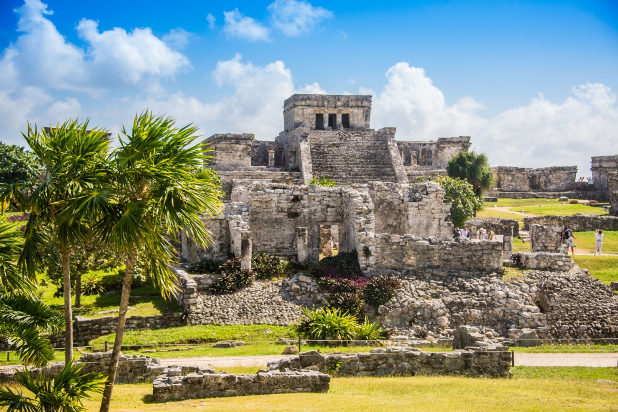
The principal god adored at Tulum is the “diving god,” or “Descending God,” and he’s represented on various buildings, including the famed pyramid-shaped landmark known as El Castillo (The Castle).
El Castillo
El Castillo is one of the city’s best-known towers. It is a pyramid-shaped structure positioned on a cliff overlooking the Caribbean Sea.
“El Castillo” translates to “The Castle” in English, and while it isn’t a typical castle, its strategic location makes it a focal point of Tulum.
El Castillo’s exact function is uncertain. Its location at the highest point of the ancient city and the panoramic view of the Caribbean Sea suggest that it may have been used to observe celestial events or to hold ceremonies.
Other research argues that El Castillo’s location may have served as a navigational aid for maritime Maya traders.
Pyramids in El Tajín
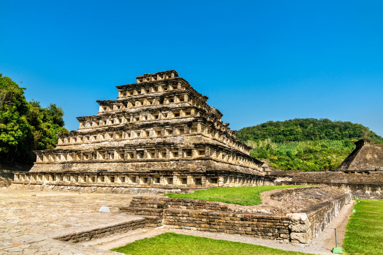
The city of Veracruz is an epicenter of the mysterious and fascinating archaeological ruins El Tajin, meaning “thunder” in the Toltec language.
The massive ancient monument is supposed to have served as a significant religious and political center between 800 and 1200 AD, and it’s believed to have been constructed by the Mayans.
El Tajin is thought to be home to more than 150 ancient sites, although only approximately twenty have been discovered and repaired so far. One of the most intriguing of the twenty or so structures is the Pirámide de los Nichos.
Pirámide de los Nichos
The Pirámide de los Nichos translates as the Pyramide of the Niches, and with good reason — it’s a seven-tiered pyramid engraved with hundreds of holes in its walls.
The size of the holes varies — some are square and deep, while others are shallow rectangles — which further complicates the aim to find the true meaning behind this pyramid’s design.
Some believe that the holes were built to improve the pyramid’s aesthetic, and were meant to hold stucco figurines, incense burners, or other ritual artifacts. Others believe the number of niches and their arrangement have a cosmological meaning, possibly tied to the Totonac calendar.
Like many other structures at El Tajn and all around Mexico, this pyramid was most likely used for ceremonial purposes, as traces of beeswax candles were discovered on the first floor of this pyramid.
Pyramids in Coba
Coba is an ancient Maya city in Quintana Roo that existed between 600 and 900 AD during the Classic period of the Mayan civilization.
Coba means “wind-stirred waters” or “ruffled waters,” which may derive from the city’s placement between two lagoons — the Coba Lagoon and the Macamxoc Lagoon.
This ancient city is rich in more than 30 stelae, engraved with depictions of the city’s rulers, their dress code, of the kinds of rituals they practiced, and reports of significant historical occurrences.
However, Coba’s most notable trait is, by far, its extensive network of paths known as “sacbe.” These pathways are also called “white roads” due to their white limestone surface.
There are more than 50 pathways built at different heights — some are as low as 1.5 feet (0.5 meters), while others are up to 8 feet tall (2.5 meters).
These roads extend in all directions — east, west, north, and south — and provide direct access to the nearby towns as well as access to the nearby locations. For instance, the longest route travels directly to the historic city of Yaxuná for about 60 miles (100 km).
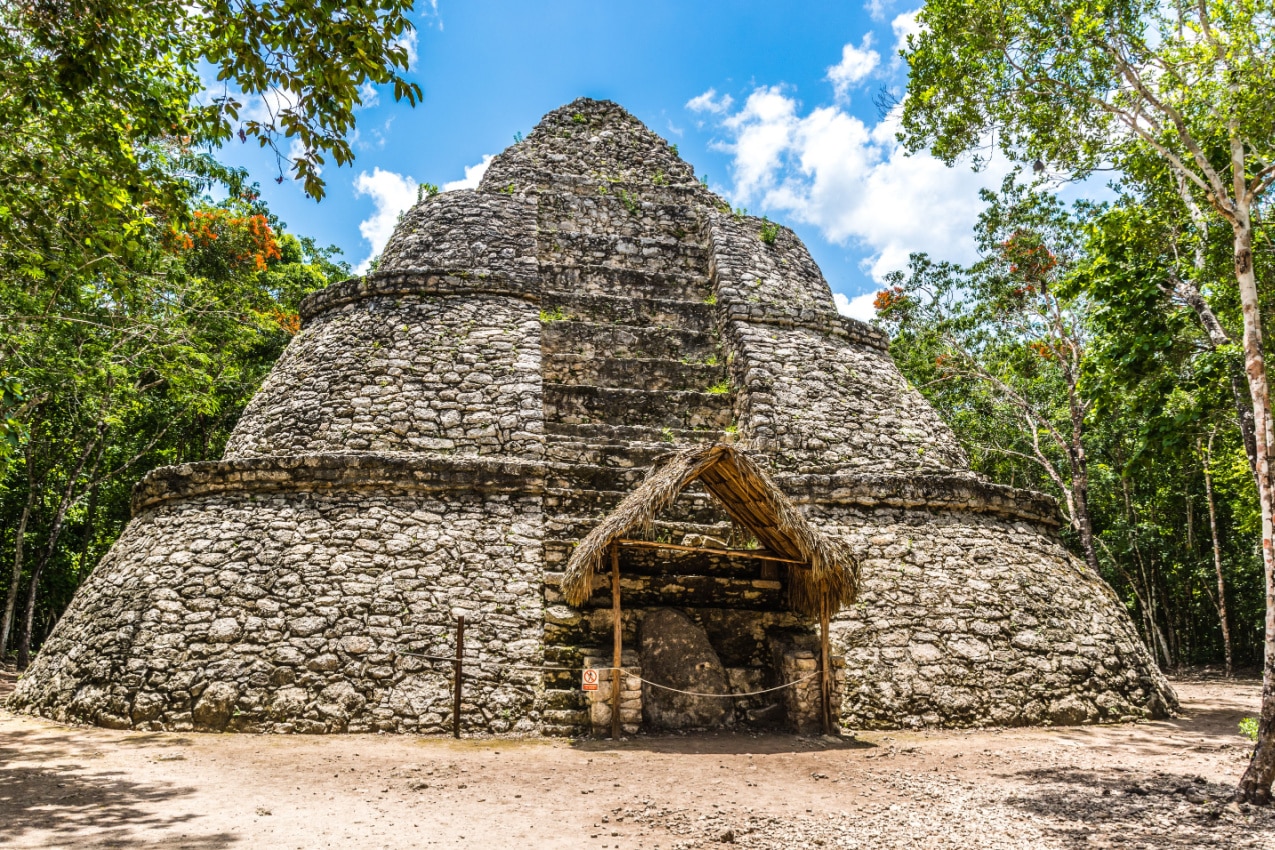
What’s even more mind-boggling is that all the roads start from the same place — the Nohoch Mul Pyramid, probably the most famous pyramid in all of Coba.
Nohoch Mul Pyramid
Nohoch Mul is the tallest Mayan pyramid on the Yucatan Peninsula, reaching a striking height of about 138 feet (42 meters). Its name, which in Yucatec Maya translates as “Large Mound” or “Big Hill,” perfectly captures its enormous dominating size.
The pyramid is made up of steps or levels that get smaller as they get closer to the apex. The central stairway of the pyramid leads to the peak, where tourists can enjoy stunning vistas of the surrounding jungle and lakes.
The Nohoch Mul Pyramid was most likely used for deity offerings, rites, and rituals, and its lofty elevation may have also had symbolic connotations relating to Maya cosmology beliefs.
Pyramids in Uxmal
Uxmal is an ancient Maya city on the Yucatán Peninsula that thrived during the late Classic period of Maya civilization (about 700–1000 AD).
The city is well-recognized for its so-called “Puuc” architecture, featuring a finely carved stone façade, mosaic motifs, and decorative components. The name “Puuc” is derived from the Puuc hills, which are located nearby.
Uximal is one of Mexico’s best preserved ancient sites, thanks to its well-cut stones set in a concrete base. As a result, tourists may get a clear sense of how the city looked in ancient times. Some of the most well-preserved places include the Governor’s Palace, Nunnery Quadrangle, the vast ballcourt, and the most stunning site — the Pyramid of the Magician.
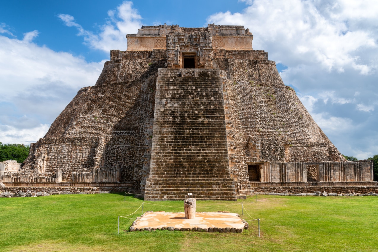
Pyramid of the Magician
The Pyramid of the Magician is also known as the Pyramid of the Dwarf, which may be derived from a story from ancient Maya mythology about a dwarf who mysteriously built the pyramid overnight.
The pyramid’s circular or elliptical foundation distinguishes it from other Maya pyramids — given that the majority of Maya pyramids have square or rectangular bases.
Its construction took place over the course of multiple phases, each of which added levels and altered the structure’s upward ascent. The exquisite carvings on its façade feature masks, serpents, and other symbolic themes that reflect Maya cosmology and religious beliefs.
Tips for Visiting Mexico’s Pyramids
Mexico’s pyramids are gigantic constructions located in remote regions, lush jungles, and exposed to the hot sun. We have a few tips for you that can make your visit to any of these historic sites easy and enjoyable.
When visiting the pyramids in Mexico, make note of the following:
- Check the opening hours of these sites (many sites and museums in Mexico are closed on Mondays).
- Remember there’s free admission to most sites for Mexican nationals on Sundays; therefore, they’re usually the busiest days.
- Expect to pay an entrance fee of $65 to $85 pesos (US$3.25-$4.25).
- Wear sun protection, a hat, or an umbrella to protect yourself from the sun.
- Stay hydrated and always carry bottled water with you (tap water is potentially unsafe).
- Wear sturdy shoes rather than flip-flops.
- Be aware that the pyramids are steep with narrow stairs, so you must be fit enough to be able to climb to the top.
- Pack insect repellent.
- In case you see a wild animal, don’t disturb them or offer them food. You may encounter wild animals such as iguanas, spider monkeys, snakes, and exotic birds.
- Be aware that taking objects from Mexican archeological sites is strictly prohibited.
- You can use smartphones and cameras, but drones are strictly prohibited on these archeological sites.
- You must apply for a permit from the National Institute of Anthropology and History (INAH) if you want to record the ancient sites for professional purposes.
Conclusion
So, which pyramid has made it to the top of your bucket list? Is it the famed Pyramid of the Sun at Teotihuacán, the jungle-covered site of Palenque, or the beautifully carved Temple of Warriors at Chichen Itza?
If you ask us, all of them are worth seeing — and although our guide is ending, your pyramid party has only just begun! So take a map, pinpoint their locations, and may you have the best expedition to Mexico’s pyramids.