Background: Great Britain formally acquired possession of Malta in 1814. The island staunchly supported the UK through both World Wars and remained in the Commonwealth when it became independent in 1964. A decade later Malta became a republic. Over the last 15 years, the island has become a major freight transshipment point, financial center, and tourist destination. It is an official candidate for EU membership.
Government type: parliamentary democracy
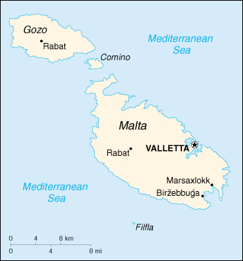
Capital: Valletta
Currency: 1 Maltese lira (LM) = 100 cents
Geography of Malta
Location: Southern Europe, islands in the Mediterranean Sea, south of Sicily (Italy)
Geographic coordinates: 35 50 N, 14 35 E
Area:
total: 316 sq km
land: 316 sq km
water: 0 sq km
Land boundaries: 0 km
Coastline: 140 km
Maritime claims:
contiguous zone: 24 nm
continental shelf: 200-m depth or to the depth of exploitation
exclusive fishing zone: 25 nm
territorial sea: 12 nm
Climate: Mediterranean with mild, rainy winters and hot, dry summers
Terrain: mostly low, rocky, flat to dissected plains; many coastal cliffs
Elevation extremes:
lowest point: Mediterranean Sea 0 m
highest point: Ta’Dmejrek 253 m (near Dingli)
Natural resources: limestone, salt, arable land
Land use:
arable land: 38%
permanent crops: 3%
permanent pastures: 0%
forests and woodland: 0%
other: 59% (1993 est.)
Irrigated land: 10 sq km (1993 est.)
Environment – current issues: very limited natural fresh water resources; increasing reliance on desalination
Environment – international agreements:
party to: Air Pollution, Biodiversity, Climate Change, Desertification, Endangered Species, Hazardous Wastes, Law of the Sea, Marine Dumping, Nuclear Test Ban, Ozone Layer Protection, Ship Pollution, Wetlands
signed, but not ratified: Climate Change-Kyoto Protocol
Geography – note: the country comprises an archipelago, with only the three largest islands (Malta, Ghawdex or Gozo, and Kemmuna or Comino) being inhabited; numerous bays provide good harbors; Malta and Tunisia are discussing the commercial exploitation of the continental shelf between their countries, particularly for oil exploration.
People of Malta
Malta is one of the most densely populated countries in the world. Inhabited since prehistoric times, Malta was first colonized by the Phoenicians. Subsequently, Maltese life and culture have been influenced to varying degrees by Arabs, Italians, and the British. Most of the foreign community in Malta, predominantly active or retired British nationals and their dependents, centers around Sliema and surrounding modern suburbs. Roman Catholicism is established by law as the religion of Malta; however, full liberty of conscience and freedom of worship are guaranteed, and a number of faiths have places of worship on the island. Malta has two official languages–Maltese (a Semitic language) and English. The literacy rate has reached 89%, compared to 63% in 1946. Schooling is compulsory until age 16.
Population: 398,534 (July 2005 est.)
Age structure:
0-14 years: 19.98%
15-64 years: 67.49%
65 years and over: 12.53%
Population growth rate: 0.74%
Birth rate: 12.75 births/1,000 population
Death rate: 7.74 deaths/1,000 population
Net migration rate: 2.37 migrant(s)/1,000 population
Infant mortality rate: 5.83 deaths/1,000 live births
Life expectancy at birth:
total population: 78.1 years
male: 75.64 years
female: 80.79 years
Total fertility rate: 1.92 children born/woman
Nationality:
noun: Maltese (singular and plural)
adjective: Maltese
Ethnic groups: Maltese (descendants of ancient Carthaginians and Phoenicians, with strong elements of Italian and other Mediterranean stock)
Religions: Roman Catholic 91%
Languages: Maltese (official), English (official)
Literacy:
definition: age 10 and over can read and write
total population: 88.76%
male: 86.91%
female: 89.55% (1995 census)
History of Malta
Malta was an important cultic center for earth-mother worship in the 4th millennium B.C. Recent archeological work shows a developed religious center there long before those of Sumer and Egypt. Malta’s written history began well before the Christian era. Originally the Phoenicians, and later the Carthaginians, established ports and trading settlements on the island. During the second Punic War (218 B.C.), Malta became part of the Roman Empire. During Roman rule, in A.D. 60, Saint Paul was shipwrecked on Malta at a place nowl called St. Paul’s Bay. In 533 A.D. Malta became part of the Byzantine Empire and in 870 came under Arab control. Arab occupation and rule left a strong imprint on Maltese life, customs, and language. The Arabs were driven out in 1090 by a band of Norman adventurers under Count Roger of Normandy, who had established a kingdom in southern Italy and Sicily. Malta thus became an appendage of Sicily for 440 years. During this period, Malta was sold and resold to various feudal lords and barons and was dominated successively by the rulers of Swabia, Aquitaine, Aragon, Castile, and Spain.
In 1523, a key date in Maltese history, the islands were ceded by Charles V of Spain to the rich and powerful order of the Knights of St. John of Jerusalem. For the next 275 years, these famous “Knights of Malta” made the island their kingdom. They built towns, palaces, churches, gardens, and fortifications and embellished the island with numerous works of art and culture. In 1565, these knights broke the siege of Malta by Suleiman the Magnificent. The power of the knights declined, however, and their rule of Malta was ended by their surrender to Napoleon in 1798.
The people of Malta rose against French rule and, with the help of the British, evicted them in 1800. In 1814, Malta voluntarily became part of the British Empire. Under the United Kingdom, the island became a military and naval fortress, the headquarters of the British Mediterranean fleet. During World War II, Malta survived a siege at the hands of German and Italian military forces (1940-43). In recognition, King George VI in 1942 awarded the George Cross “to the island fortress of Malta–its people and defenders.” President Franklin Roosevelt, describing the wartime period, called Malta “one tiny bright flame in the darkness.” Malta obtained independence on September 21, 1964.
Malta Economy
Economy – overview: Major resources are limestone, a favorable geographic location, and a productive labor force. Malta produces only about 20% of its food needs, has limited freshwater supplies, and has no domestic energy sources. The economy is dependent on foreign trade, manufacturing (especially electronics and textiles), and tourism. Malta is privatizing state-controlled firms and liberalizing markets in order to prepare for membership in the European Union. However, the island is divided politically over the question of joining the EU. The sizable budget deficit remains a key concern.
GDP: purchasing power parity – $5.6 billion (2000 est.)
GDP – real growth rate: 3.4% (2000 est.)
GDP – per capita: purchasing power parity – $14,300 (2000 est.)
GDP – composition by sector:
agriculture: 2.8%
industry: 25.5%
services: 71.7% (1999)
Inflation rate (consumer prices): 2.5% (2000 est.)
Labor force: 145,901 (1999)
Labor force – by occupation: industry 24%, services 71%, agriculture 5% (1999 est.)
Unemployment rate: 4.5% (3rd Quarter 2000)
Budget:
revenues: $1.6 billion
expenditures: $1.73 billion, including capital expenditures of $265.4 million (1999)
Industries: tourism; electronics, ship building and repair, construction; food and beverages, textiles, footwear, clothing, tobacco
Electricity – production: 1.65 billion kWh (1999)
Electricity – production by source:
fossil fuel: 100%
hydro: 0%
nuclear: 0%
other: 0% (1999)
Electricity – consumption: 1.534 billion kWh (1999)
Agriculture – products: potatoes, cauliflower, grapes, wheat, barley, tomatoes, citrus, cut flowers, green peppers; pork, milk, poultry, eggs
Exports: $2 billion (f.o.b., 1999)
Exports – commodities: machinery and transport equipment, manufactures
Exports – partners: United States 21.4%, France 15.2%, Germany 12.6%, UK 9.3%, Italy 4.9% (1999)
Imports: $2.6 billion (f.o.b., 1999)
Imports – commodities: machinery and transport equipment, manufactured goods; food, drink, and tobacco
Imports – partners: Italy 16.7%, UK 10.9%, Germany 10.0%, United States 8.5% (1999)
Debt – external: $130 million (1997)
Currency: Maltese lira (MTL)
Map of Malta