Background: In 1979 the Federated States of Micronesia (FSM), a UN Trust Territory under US administration, adopted a constitution. In 1986 independence was attained under a Compact of Free Association with the United States. Present concerns include large-scale unemployment, overfishing, and overdependence on US aid.
Government type: constitutional government in free association with the US; the Compact of Free Association entered into force 3 November 1986.
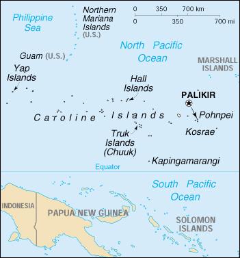
Capital: Palikir
Currency: 1 United States dollar (US$) = 100 cents
Geography of Micronesia
Location: Micronesia consists of 607 islands extending 1,800 miles across the archipelago of the Caroline Islands east of the Philippines. The four constituent island groups are Yap, Chuuk (called Truk until January 1990), Pohnpei (called Ponape until November 1984), and Kosrae. The federal capital, Palikir, is on Pohnpei.
Geographic coordinates: 6 55 N, 158 15 E
Area:
total: 702 sq km
land: 702 sq km
water: 0 sq km
note: includes Pohnpei (Ponape), Truk (Chuuk) Islands, Yap Islands, and Kosrae
Land boundaries: 0 km
Coastline: 6,112 km
Maritime claims:
exclusive economic zone: 200 nm
territorial sea: 12 nm
Climate: tropical; heavy year-round rainfall, especially in the eastern islands; located on southern edge of the typhoon belt with occasionally severe damage
Terrain: islands vary geologically from high mountainous islands to low, coral atolls; volcanic outcroppings on Pohnpei, Kosrae, and Truk
Elevation extremes:
lowest point: Pacific Ocean 0 m
highest point: Totolom 791 m
Natural resources: forests, marine products, deep-seabed minerals
Natural hazards: typhoons (June to December)
Environment – current issues: overfishing
Environment – international agreements:
party to: Biodiversity, Climate Change, Climate Change-Kyoto Protocol, Desertification, Hazardous Wastes, Law of the Sea, Ozone Layer Protection
signed, but not ratified: none of the selected agreements
Geography – note: four major island groups totaling 607 islands
People of Micronesia
The ancestors of the Micronesians settled the Caroline Islands over 4,000 years ago. A decentralized chieftain-based system eventually evolved into a more centralized economic and religious empire centered on Yap. The indigenous population, which is predominantly Micronesian, consists of various ethnolinguistic groups. English has become the common language. Population growth remains high at more than 3%, ameliorated somewhat by net emigration.
Population: 108,105 (July 2005 est.)
Population growth rate: 3.28%
Birth rate: 27.09 births/1,000 population
Death rate: 5.95 deaths/1,000 population
Net migration rate: 11.65 migrant(s)/1,000 population
Infant mortality rate: 33.48 deaths/1,000 live births
Life expectancy at birth:
total population: 68.63 years
male: 66.67 years
female: 70.62 years
Total fertility rate: 3.83 children born/woman
Nationality:
noun: Micronesian(s)
adjective: Micronesian; Kosrae(s), Pohnpeian(s), Trukese, Yapese
Ethnic groups: nine ethnic Micronesian and Polynesian groups
Religions: Roman Catholic 50%, Protestant 47%, other and none 3%
Languages: English (official and common language), Trukese, Pohnpeian, Yapese, Kosrean
Literacy:
definition: age 15 and over can read and write
total population: 89%
male: 91%
female: 88% (1980 est.)
Micronesia Economy
Under the terms of the Compact of Free Association, the U.S. will provide Micronesia with over $1 billion in grants and services from 1986 to 2001. The largest single item is an annual block grant, which has declined in three 5-year phases. Annual payments for seven specific categories of programs, including health and education, have been made in fixed amounts since the Compact’s inception. The entire package is adjusted each year for inflation. In 1997 the U.S. provided more than $78 million in Compact assistance–an amount equivalent to over one-third of FSM’s GDP–plus another $11 million through other federal programs. Total official development assistance from all sources was $101 million in 1997, with nearly 90% of that total coming from the U.S.
The Micronesia public sector plays a central role in the economy as the administrator of the Compact money. The national and state-level governments employ over one-half of the country’s workers and provide services accounting for more than 40%of GDP. Faced with the potential decrease or cessation of some of the assistance programs upon the Compact’s expiry in 2001, the Government of the FSM in 1996 began to implement a program of economic reforms designed to reduce the role of the public sector in the economy.
The fishing industry also is highly important. Foreign commercial fishing fleets pay over $20 million annually for the right to operate in FSM territorial waters. These licensing fees account for nearly 30% of domestic budgetary revenue. Additionally, exports of marine products, mainly reexports of fish to Japan, account for nearly 85% of export revenue.
The tourist industry is present but has been hampered by a lack of infrastructure. Visitor attractions include scubadiving (notably in Chuuk Lagoon), World War II battle sites, and the ancient ruined city of Nan Madol on Pohnpei. Some 15,000 tourists visit the islands each year. The Asian Development Bank has identified tourism as one of FSM’s highest potential growth industries.
Farming is mainly subsistence, and its importance is declining. The principal crops are coconuts, bananas, betel nuts, cassava, and sweet potatoes. Less than 10% of the formal labor force and less than 7% of export revenue come from the agriculture sector. Manufacturing activity is modest, consisting mainly of a garment factory in Yap and production of buttons from trochus shells.
The large inflow of official assistance to Micronesia allows it to run a substantial trade deficit and to have a much lighter tax burden than other states in the region (11% of GDP in FSM compared to 18%-25% elsewhere). The government also borrowed against future Compact disbursements in the early 1990s, yielding an external debt of $111 million in 1997 (over 50% of GDP).
GDP: purchasing power parity – $263 million (1999 est.)
note: GDP is supplemented by grant aid, averaging perhaps $100 million annually
GDP – real growth rate: 0.3% (1999 est.)
GDP – per capita: purchasing power parity – $2,000 (1999 est.)
GDP – composition by sector:
agriculture: 19%
industry: 4%
services: 77% (1996 est.)
Inflation rate (consumer prices): 2.6% (FY98/99)
Labor force – by occupation: two-thirds are government employees
Unemployment rate: 16% (1999 est.)
Budget:
revenues: $161 million ($69 million less grants)
expenditures: $160 million (1998 est.)
Industries: tourism, construction, fish processing, craft items from shell, wood, and pearls
Agriculture – products: black pepper, tropical fruits and vegetables, coconuts, cassava (tapioca), sweet potatoes; pigs, chickens
Exports: $73 million (f.o.b., 1996 est.)
Exports – commodities: fish, garments, bananas, black pepper
Exports – partners: Japan, United States, Guam
Imports: $168 million (c.i.f., 1996 est.)
Imports – commodities: food, manufactured goods, machinery and equipment, beverages
Imports – partners: United States, Japan, Australia
Debt – external: $111 million (1997 est.)
Economic aid – recipient: $79 million (1998); note – under terms of the Compact of Free Association, the US will provide $1.3 billion in grant aid during the period 1986-2001.
Currency: US dollar (USD)
Map of Micronesia