Facts About Saint Kitts and Nevis
Background: First settled by the British in 1623, the islands became an associated state with full internal autonomy in 1967. The island of Anguilla rebelled and was allowed to secede in 1971. Saint Kitts and Nevis achieved independence in 1983. In 1998, a vote in Nevis on a referendum to separate from Saint Kitts fell short of the two-thirds majority needed.
Government type: constitutional monarchy with Westminster-style parliament
Capital: Basseterre
Currency: 1 East Caribbean dollar (XCD) = 100 cents
Geography of Saint Kitts and Nevis
Location: Caribbean, islands in the Caribbean Sea, about one-third of the way from Puerto Rico to Trinidad and Tobago
Geographic coordinates: 17 20 N, 62 45 W
Area:
total: 261 sq km (Saint Kitts 168 sq km; Nevis 93 sq km)
land: 261 sq km
water: 0 sq km
Land boundaries: 0 km
Coastline: 135 km
Maritime claims:
continental shelf: 200 nm or to the edge of the continental margin
territorial sea: 12 nm
contiguous zone: 24 nm
exclusive economic zone: 200 nm
Climate: tropical tempered by constant sea breezes; little seasonal temperature variation; rainy season (May to November)
Terrain: volcanic with mountainous interiors
Elevation extremes:
lowest point: Caribbean Sea 0 m
highest point: Mount Liamuiga 1,156 m
Natural resources: arable land
Land use:
arable land: 22%
permanent crops: 17%
permanent pastures: 3%
forests and woodland: 17%
other: 41% (1993 est.)
Natural hazards: hurricanes (July to October)
Environment – international agreements:
party to: Biodiversity, Climate Change, Desertification, Endangered Species, Hazardous Wastes, Law of the Sea, Ozone Layer Protection, Ship Pollution, Whaling
signed, but not ratified: none of the selected agreements
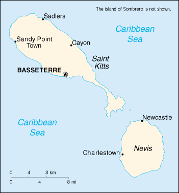
Geography – note: with coastlines in the shape of a baseball bat and ball, the two volcanic islands are separated by a three-km-wide channel called The Narrows; on the southern tip of long, baseball bat-shaped Saint Kitts lies the Great Salt Pond; Mount Nevis sits in the center of its almost circular namesake island and its ball shape complements that of its sister island.
People of Saint Kitts and Nevis
Population: 38,958 (July 2005 est.)
Age structure:
0-14 years: 29.84%
15-64 years: 61.37%
65 years and over: 8.79%
Population growth rate: -0.11%
Birth rate: 18.78 births/1,000 population
Death rate: 9.21 deaths/1,000 population
Net migration rate: -10.68 migrant(s)/1,000 population
Infant mortality rate: 16.28 deaths/1,000 live births
Life expectancy at birth:
total population: 71.01 years
male: 68.22 years
female: 73.97 years
Total fertility rate: 2.41 children born/woman
Nationality:
noun: Kittitian(s), Nevisian(s)
adjective: Kittitian, Nevisian
Ethnic groups: predominantly black some British, Portuguese, and Lebanese
Religions: Anglican, other Protestant, Roman Catholic
Languages: English
Literacy:
definition: age 15 and over has ever attended school
total population: 97%
male: 97%
female: 98% (1980 est.)
History of Saint Kitts and Nevis
Like many other islands, Christopher Columbus “saw” St. Kitts in 1493, but it must have been memorable since he eventually gave it his own name. Eventually, it was inhabited by both French and English — they settled in different parts of the island. The town of Old Road, west of Basseterre, was the English capital, while Basseterre was home to the French.
The island, along with Nevis and Montserrat, went back and forth between the two countries during the 17th and 18th centuries, which is why the influences of each can be seen on the island. The French controlled the island earlier, but the English received it during the Treaty of Utrecht in 1713. Later on, the French captured St. Kitts, Nevis and Montserrat, but they went back to England in 1783 with the Treaty of Versailles.
The first settlers in St. Kitts came in 1623 with Sir Thomas Warner, who created the first English settlement in the Caribbean. His tomb today is widely visited at St. Thomas’ Anglican Church located just west of Basseterre. The French and English continually battled it out over the years, though they banded together against the Carib Indians during a horrible massacre of the Indians at Bloody Point in 1626.
St. Kitts and Nevis were both agricultural giants growing indigo, ginger, tobacco, cotton and sugar cane in particular. Nevis was a booming commercial centre at one time as well as a fashionable spa. When the sugar industry died off because of the introduction of the sugar beet and the emancipation of slaves, Nevis supported itself basically on tourism as it does today. St. Kitts continued with sugar, which the government nationalised 20 years ago, and still runs the production of cane today.
St. Kitts, Nevis and Anguilla went together in 1967 to form the Associated State of the United Kingdom. Anguilla went off on its own right away to return to its Crown Colony status, but St. Kitts and Nevis went off on their own to become strange bedfellows in 1983. Since then, the debate has continued over who has the best deal in the partnership, making for a somewhat rocky marriage. Many Nevisians complain that St. Kitts has the best deal, which resulted in a referendum vote on secession for Nevis. In 1998, Nevisians came close to striking out on their own, 62 percent of them favouring secession. A two-thirds was needed, leaving the two islands continuing in their strained relationship and trying to sort out the constitutional disputes between them.
Both islands still have significant British influences. The Anglican church is still dominant, tea is still served in late afternoons, and life is still quite “proper”
Saint Kitts and Nevis Economy
Economy – overview: The economy has traditionally depended on the growing and processing of sugarcane; decreasing world prices have hurt the industry in recent years. Tourism, export-oriented manufacturing, and offshore banking activity have assumed larger roles. Most food is imported. The government has undertaken a program designed to revitalize the faltering sugar sector. It is also working to improve revenue collection in order to better fund social programs. In 1997 some leaders in Nevis were urging separation from Saint Kitts on the basis that Nevis was paying far more in taxes than it was receiving in government services, but the vote on cessation failed in August 1998. In late September 1998, Hurricane Georges caused approximately $445 million in damages and limited GDP growth for the year.
GDP: purchasing power parity – $274 million (2000 est.)
GDP – real growth rate: 5% (2000 est.)
GDP – per capita: purchasing power parity – $7,000 (2000 est.)
GDP – composition by sector:
agriculture: 5.5%
industry: 22.5%
services: 72% (1996)
Inflation rate (consumer prices): 2.5% (2000 est.)
Labor force: 18,172 (June 1995)
Unemployment rate: 4.5% (1997)
Budget:
revenues: $64.1 million
expenditures: $73.3 million, including capital expenditures of $10.4 million (1997 est.)
Industries: sugar processing, tourism, cotton, salt, copra, clothing, footwear, beverages
Electricity – production: 90 million kWh (1999)
Electricity – production by source:
fossil fuel: 100%
hydro: 0%
nuclear: 0%
other: 0% (1999)
Electricity – consumption: 83.7 million kWh (1999)
Agriculture – products: sugarcane, rice, yams, vegetables, bananas; fish
Exports: $53.2 million (2000 est.)
Exports – commodities: machinery, food, electronics, beverages, tobacco
Exports – partners: United States 68.5%, UK 22.3%, Caricom countries 5.5% (1995 est.)
Imports: $151.5 million (2000 est.)
Imports – commodities: machinery, manufactures, food, fuels
Imports – partners: United States 42.4%, Caricom countries 17.2%, UK 11.3% (1995 est.)
Debt – external: $115.1 million (1998)
Economic aid – recipient: $5.5 million (1995)
Currency: 1 East Caribbean dollar (XCD) = 100 cents
Map of Saint Kitts and Nevis